
Positioning method and device, storage medium and receiver of multi-mode GNSS system

A positioning method and positioning device technology, applied in the field of navigation, can solve problems such as the number of visible satellites is less than 8, the overall deviation of the positioning track, and the inability to execute the RAIM algorithm, etc., to achieve stable and reliable inter-system delay value, strong stability sexual effect

Active Publication Date: 2020-09-25
SPREADTRUM COMM (SHANGHAI) CO LTD
View PDF6 Cites 0 Cited by
  • Summary
  • Abstract
  • Description
  • Claims
  • Application Information

AI Technical Summary

Problems solved by technology

[0005] However, in complex scenes, such as areas with severe signal occlusion and dense urban areas, the number of visible satellites is likely to be less than 8
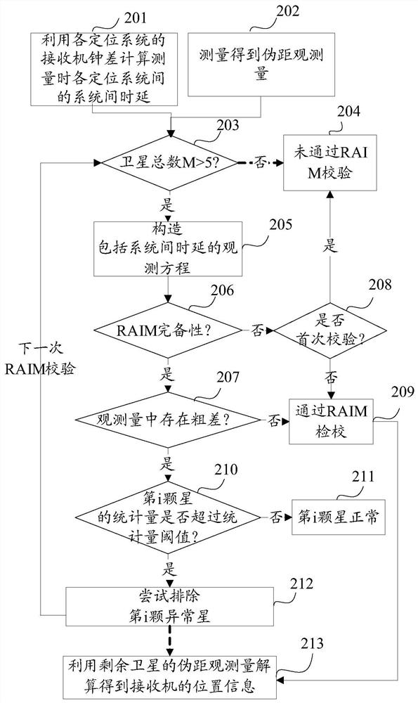
When the number of satellites in the multi-positioning system is small, the RAIM algorithm cannot be executed, and the usability of the RAIM algorithm will decrease significantly.
In addition, in this case, the multipath effect is significant. Some GNSS terminals (such as the GNSS chip on the smart phone) are limited by the size of the antenna, and it is difficult to effectively improve the influence of the multipath effect on the satellite signal source. Therefore, some satellites Observations will likely show gross errors of up to hundreds of meters
If observations with large gross errors cannot be excluded, it will seriously affect the positioning accuracy of current receivers
If it is in the first positioning stage in such an environment, the convergence process of the subsequent Kalman Filter algorithm (Kalman Filter, KF) will be affected by the error of the first positioning result, which will lead to the overall deviation of the positioning trajectory
If you pass through a road dense area with serious signal occlusion during continuous navigation, the wrong positioning results affected by gross errors will affect the real-time route planning of navigation and seriously affect the user experience

Method used


Image

  • Positioning method and device, storage medium and receiver of multi-mode GNSS system
  • Positioning method and device, storage medium and receiver of multi-mode GNSS system
  • Positioning method and device, storage medium and receiver of multi-mode GNSS system

Examples


Embodiment Construction

[0033] As described in the background art, in complex scenes, such as areas with severe signal occlusion and urban areas with dense buildings, the number of visible satellites is likely to be less than 8. However, when the number of satellites in the multi-positioning system is small, the RAIM algorithm cannot be executed, and the usability of the RAIM algorithm will decrease obviously. If observations with large gross errors cannot be excluded, it will seriously affect the positioning accuracy of current receivers. If it is in the first positioning stage in such an environment, the convergence process of the subsequent Kalman filter algorithm (Kalman Filter, KF) will be affected by the error of the first positioning result, which will lead to the overall deviation of the positioning trajectory. If the continuous navigation process passes through dense road areas with severe signal occlusion, the wrong positioning results affected by gross errors will affect the real-time rout...


PUM


Abstract

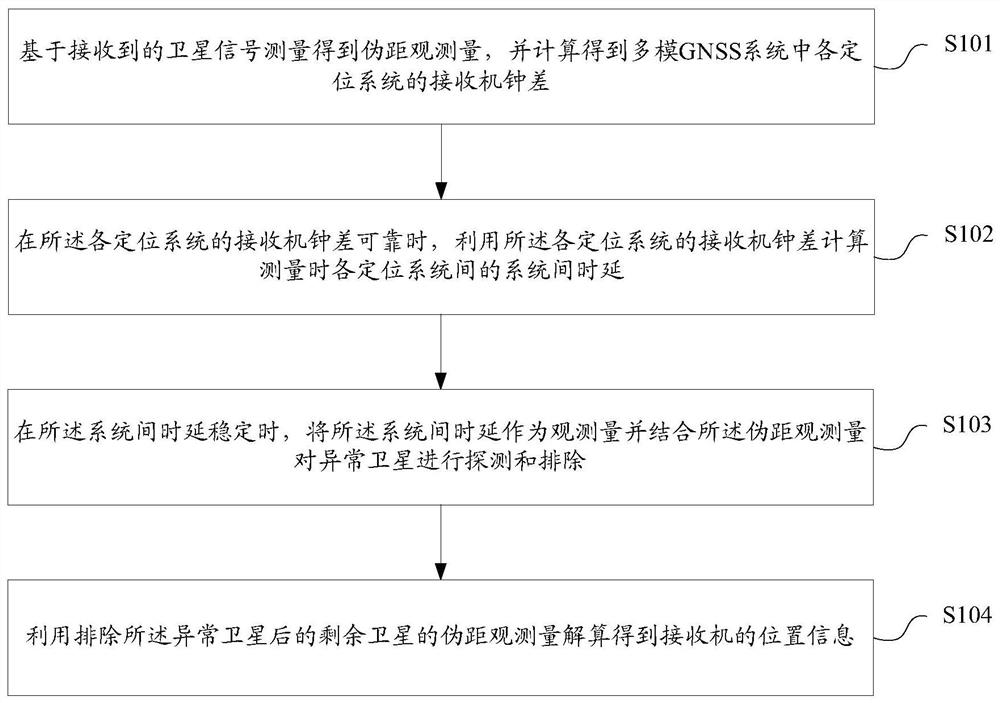
The invention discloses a positioning method and a device of a multimode GNSS system, a storage medium and a receiver. The positioning method comprises the following steps: measuring a pseudo-range observation quantity based on the received satellite signal, and calculating a receiver clock difference of each positioning system in the multimode GNSS system; using the receiver clock difference of each positioning system to calculate the inter-system time delay between each positioning system during the measurement when the receiver clock difference of each positioning system is reliable; usingthe inter-system time delay as an observation quantity and combining the pseudo-range observation quantity to detect and exclude the abnormal satellite when the inter-system time delay is stable; andusing the pseudo-range observation quantity of the remaining satellites after excluding the abnormal satellite to obtain the position information of the receiver . According to the positioning methodof the multimode GNSS system, the positioning accuracy of the receiver can be improved in a severe environment.

Description

technical field [0001] The invention relates to the technical field of navigation, in particular to a multi-mode GNSS system positioning method and device, a storage medium, and a receiver. Background technique [0002] Global Navigation Satellite System (GNSS) currently mainly includes Global Positioning System (GPS), BeiDou Satellite Navigation System (BDS), Global Navigation Satellite System (GLONASS) , EU satellite navigation system (Galileo), quasi-Zenith Satellite System (Quasi-Zenith Satellite System, QZSS) and other navigation satellite systems. For the same GNSS receiver, each satellite system corresponds to different receiver clock offsets. Furthermore, the system time of each satellite system is different, that is, the time difference between systems. The navigation message generally contains synchronization parameters with the GPS system time (GPS Time, GPST). After obtaining these parameters in the message, the time difference between systems can be obtained b...

Claims


Application Information

Patent Timeline
Patent Type & Authority Patents(China)
IPC IPC(8): G01S19/37G01S19/33G01S19/20
CPCG01S19/20G01S19/33G01S19/37
Inventor 李茂
Owner SPREADTRUM COMM (SHANGHAI) CO LTD
Learn More