Eureka AIR delivers breakthrough ideas for toughest innovation challenges, trusted by R&D personnel around the world.

Method for joint inversion of forest aboveground biomass by integrating three data sources

A joint inversion and biomass technology, which is applied in image data processing, complex mathematical operations, details involving image mosaic, etc., can solve the comprehensive and in-depth calculation of forest canopy high-precision spatial detail features and spectral features of lidar features , no fusion and other problems, to achieve the effect of suppressing high forest coverage, enhancing ability and accuracy, and easy method transplantation

Active Publication Date: 2018-11-30
NANJING FORESTRY UNIV
View PDF7 Cites 32 Cited by
  • Summary
  • Abstract
  • Description
  • Claims
  • Application Information

AI Technical Summary

Problems solved by technology

However, the above methods are based on two types of data sources, and do not integrate high-resolution CCD, hyperspectral and lidar data acquired simultaneously to improve the accuracy of forest aboveground biomass estimation
At the same time, there is no comprehensive and in-depth calculation of high-precision spatial detail features, spectral features, and lidar feature extraction methods for forest canopies.

Method used


Image

  • Method for joint inversion of forest aboveground biomass by integrating three data sources
  • Method for joint inversion of forest aboveground biomass by integrating three data sources
  • Method for joint inversion of forest aboveground biomass by integrating three data sources

Examples


Embodiment 1

[0052] The experimental area of ​​this example is located in the state-run Yushan Forest Farm (120.70°E, 31.67°N) in Changshu City, Jiangsu Province, with an area of ​​about 1422hm 2 , the range of elevation change is 2-261m. The experimental area is located in a subtropical monsoon climate with an annual precipitation of 1062.5 mm. Its forest type belongs to subtropical secondary mixed forest, which can be subdivided into coniferous forest, broad-leaved forest and mixed forest. Among them, the main coniferous and broad-leaved deciduous tree species include Pinus massoniana, Quercus acutissima, Liquidambar formosana and Chestnut (Castanea mollissima), and some evergreen broad-leaved tree species.

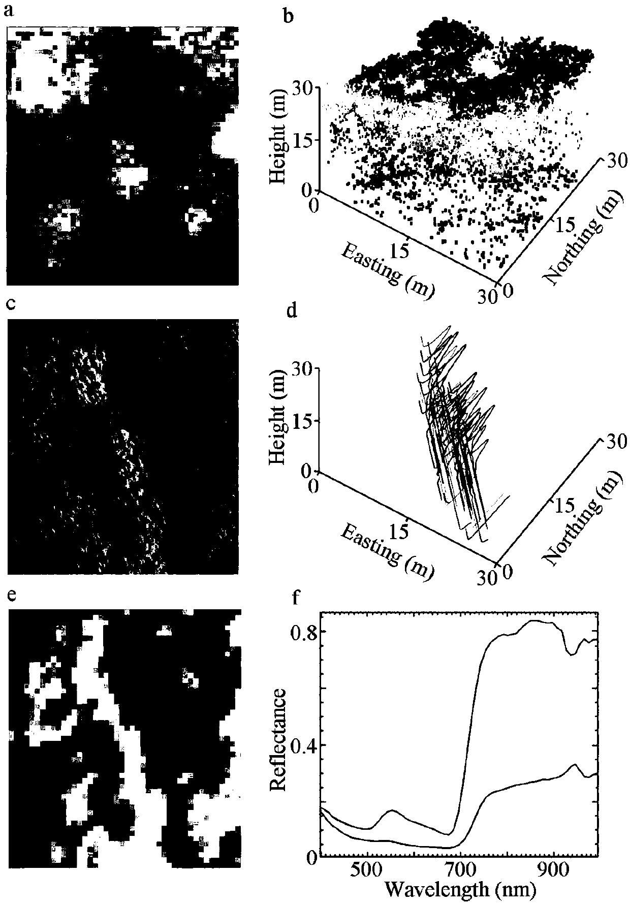
[0053] Collect high-resolution CCD images, hyperspectral images and lidar point cloud data with the help of aviation aircraft. For specific data, see figure 1 .

[0054] exist figure 1 Middle a: canopy digital surface model extracted from lidar data; b: side view of sample site ...


PUM


Abstract

The invention discloses a method for joint inversion of forest aboveground biomass by integrating high-resolution CCD data, hyperspectral image data and laser radar point cloud data. According to themethod, first, geometric correction and stitching preprocessing are performed on airborne high-resolution CCD images, geometric correction and atmospheric correction preprocessing are performed on hyperspectral images, filtering and interpolation are performed on the laser radar point cloud data to generate a digital terrain model, and the point cloud data is normalized; second, texture features,spectral features and point cloud structural features are extracted based on three data sources obtained after preprocessing respectively; and last, models are constructed respectively in combinationwith ground measured data and extracted feature variables to predict the forest aboveground biomass. Through the method, the forest aboveground biomass of a subtropical natural secondary forest is extracted; and compared with aboveground biomass estimation results obtained by using other approximate remote sensing methods, the relative root-mean-square error of the method is lowered by 10% or above.

Description

technical field [0001] The invention relates to the fields of forest resource monitoring, environmental factor investigation and the like, and specifically relates to a method for jointly retrieving forest aboveground biomass by integrating three types of data sources. Background technique [0002] Accurate forest aboveground biomass extraction is of great significance for forest resources monitoring and environmental factor investigation. At the same time, this information can also be used to grasp the relationship between forest plants and the environment, and the laws of forest growth, development, renewal, and succession, which are of great significance for sustainable forest management, ecosystem carbon cycle research, and understanding of global climate change. Conventional aboveground biomass extraction in forests mainly relies on field measurements or statistical analysis methods based on field measurements, and its accuracy is often low, and it is difficult to be pr...

Claims


Application Information

Patent Timeline
IPC IPC(8): G06T7/40G06T5/00G06T3/40G06K9/62G06F17/18
CPCG06F17/18G06T3/4038G06T7/40G06T2200/32G06F18/214G06T5/70
Inventor 申鑫曹林云挺刘浩汪贵斌
Owner NANJING FORESTRY UNIV
Why Eureka
Eureka Blog
Learn More