A comprehensive performance evaluation system and method for spatial information network

A technology for spatial information network and comprehensive performance evaluation, applied in the information field, can solve problems such as high complexity, slow movement, and high difficulty, and achieve the effect of simplifying the convenience of calculation, facilitating the bottleneck problem, and taking into account the rationality.

Active Publication Date: 2020-03-17
INST OF SOFTWARE - CHINESE ACAD OF SCI
View PDF5 Cites 0 Cited by
  • Summary
  • Abstract
  • Description
  • Claims
  • Application Information

AI Technical Summary

Problems solved by technology

[0003] At present, available methods have been proposed for the performance evaluation of satellite data relay systems. The evaluation indicators used have developed from purely technical indicators such as signal-to-noise ratio to various indicators based on service quality and user experience, but mainly focus on different Performance evaluation of specific transmission models at the network layer, such as performance evaluation for traditional cellular networks, where the relative positions of network nodes are relatively fixed, and user needs are relatively single and move slowly
There are also tools such as the random Petri net software package SPNP, which are also used to analyze the performance of satellite networks, but they highly abstract satellites into nodes in the Petri net, which is difficult to meet the needs of practical applications
QoS (Quality of Service) defined in RFC 3644 refers to the ability of a network to provide services, and its key indicators mainly include: availability, throughput, delay, delay variation (including jitter and drift) and loss, etc. Although there have been research results, there is still a certain distance from practicality, standards have not yet been formed, and relevant indicators are difficult to reflect the characteristics of spatial information network performance
In addition, the spatial information network operates in a highly dynamic environment, which increases the uncertainty of QoS measurement
[0004] In the space information network environment, compared with the traditional network system, the services provided by the space information network have the characteristics of typical correlation, periodicity, burstiness and sparseness, etc., and the network traffic in it also shows that it changes with time and space. The changes are drastic, and the existing performance evaluation methods for traditional networks are difficult to apply to space system networks, a comprehensive system that integrates space and ground.
The difficulty of performance evaluation and the high complexity of evaluation have become one of the bottlenecks in the planning and management of spatial information network construction

Method used


Image

  • A comprehensive performance evaluation system and method for spatial information network
  • A comprehensive performance evaluation system and method for spatial information network
  • A comprehensive performance evaluation system and method for spatial information network

Examples


Embodiment Construction

[0063] The present invention will be further described in detail with reference to the accompanying drawings and embodiments. These implementation examples are described in sufficient detail to enable those skilled in the art to understand and practice the present invention. Logical, implementation and other changes may be made in the implementation without departing from the spirit and scope of the invention. Therefore, the following detailed description should not be taken in a limiting sense, and the scope of the present invention is defined only by the claims.

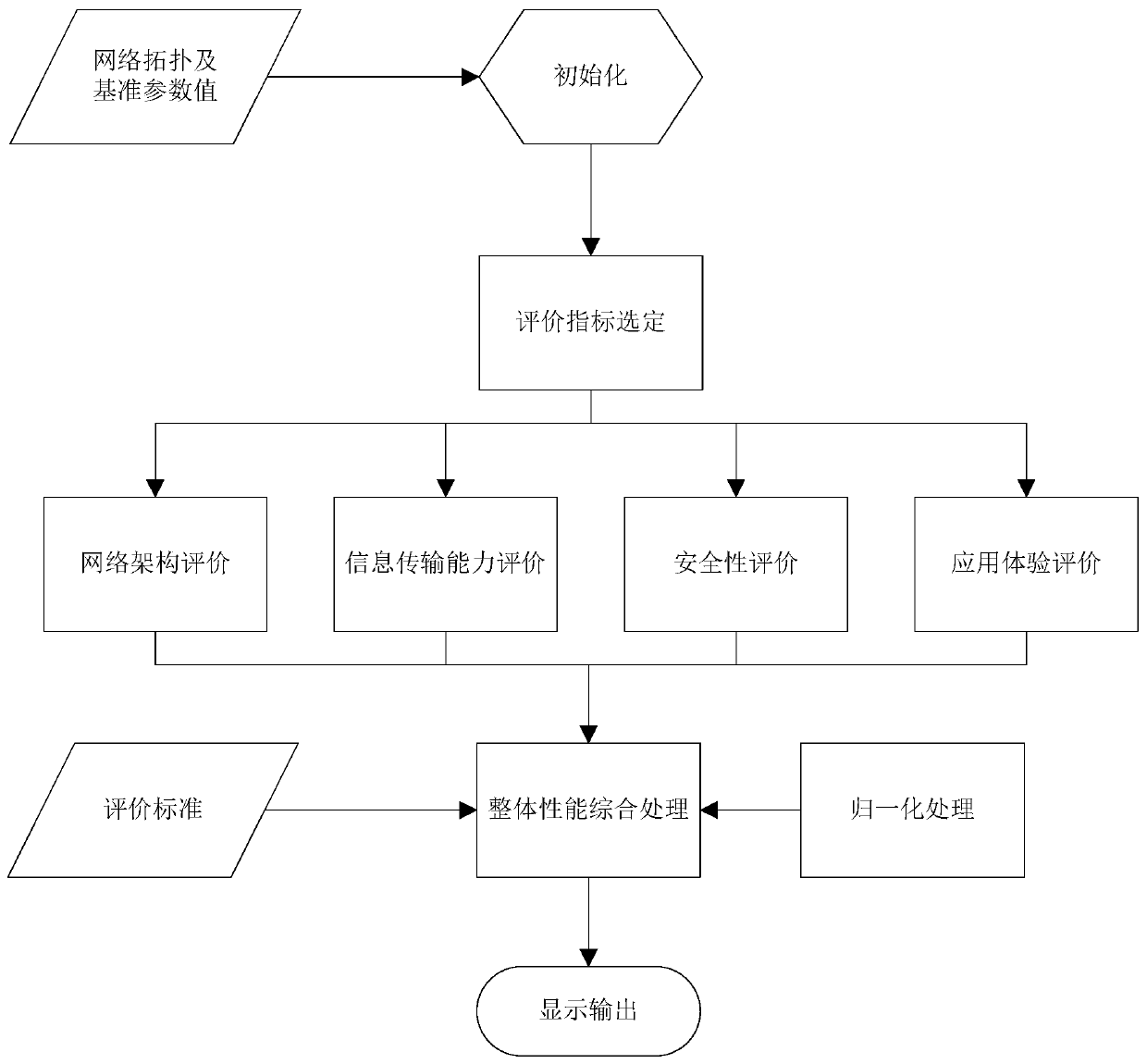
[0064] Such as figure 1 As shown, the spatial information network comprehensive performance evaluation system and method of the present invention mainly include a network architecture evaluation module, an information transmission capability evaluation module, a security evaluation module, an application experience evaluation module and an overall performance comprehensive processing module.

[0065] The whole im...


PUM


Abstract

The invention discloses a comprehensive performance evaluation system and method for a spatial information network. The comprehensive performance evaluation system comprises a network architecture evaluation module, an information transmission capacity evaluation module, a security evaluation module, an application experience evaluation module and an overall performance comprehensive processing module. The comprehensive performance evaluation system can reflect the rationality and robustness of the network architecture, the information transmission capacity, the security and the ability of meeting concurrent service requirements, can be tailored according to requirements of an evaluation target and is used for analyzing the comprehensive performance of the spatial information network on the whole. The normalized setting for indicator values and evaluation weights gives consideration to the rationality and the calculation convenience and simplifies comparative analysis, thereby being capable of better adapting to the characteristics of large scale and high dynamic of the spatial information network, solving adverse effects brought about by the spatial and temporal uncertainty to thenetwork performance measurement, eliminating evaluation result changes brought about by obvious differences existing in measurement accuracy, measurement time and measurement load, and thus providingsupport for planning design and operation management of the spatial information network.

Description

technical field [0001] The invention relates to the field of information technology, in particular to a space information network system performance evaluation system and method. Background technique [0002] Space information network refers to a space-ground integrated network system composed of satellite networks composed of satellites of different application types and different orbital heights and ground networks. The performance evaluation of the spatial information network is of great significance to improve the response speed of the network and overcome the bottleneck of the application. It is also the basis for network planning and optimization. It also has important reference value for the evaluation, improvement and development of network protocols. Mathematical analysis, computer simulation and actual measurement are the three basic methods of network performance analysis and evaluation, and the determination and acquisition of evaluation indicators is an importan...

Claims


Application Information

Patent Timeline
Patent Type & Authority Patents(China)
IPC IPC(8): H04L12/24H04L12/26
CPCH04L41/14H04L43/08
Inventor 彭启民刘立祥
Owner INST OF SOFTWARE - CHINESE ACAD OF SCI
Why Eureka
Try Eureka