
A ground-based receiver-based method for fast star-finding and orbit determination of navigation satellites

A technology of navigation satellites and receivers, applied in the field of satellite communications, can solve problems such as inability to quickly and effectively find and locate satellites, and achieve the effects of fast orbit determination, improved search accuracy, and more stable results

Active Publication Date: 2022-06-17
SPACE STAR TECH CO LTD
View PDF9 Cites 0 Cited by
  • Summary
  • Abstract
  • Description
  • Claims
  • Application Information

AI Technical Summary

Problems solved by technology

The existing Beidou positioning cannot quickly and effectively find and locate stars in some areas

Method used


Image

  • A ground-based receiver-based method for fast star-finding and orbit determination of navigation satellites
  • A ground-based receiver-based method for fast star-finding and orbit determination of navigation satellites
  • A ground-based receiver-based method for fast star-finding and orbit determination of navigation satellites

Examples


Embodiment Construction

[0042] Hereinafter, the present invention will be described in detail based on the drawings.

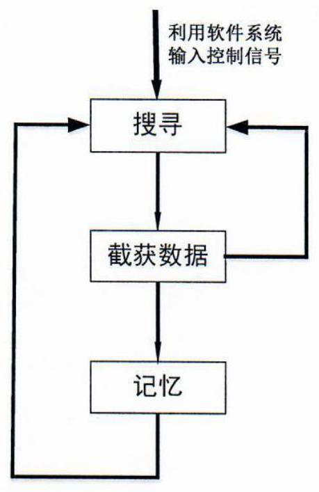
[0043] like figure 1 As shown in the figure, after power-on, the ground receiver information processing unit first performs interface setting and initialization according to the setting parameters, and searches in a spiral according to the pre-made location area, there are two ways;

[0044] With the preset position as the center of ±90°, when the search range is divided into an odd number of search areas, first carry out a spiral search for the preset position area, and then carry out a spiral search for different search areas on both sides of the center;

[0045] Take the preset position as the center, and the search range is ±90° from the center. When the search range is divided into an even number of search areas, first perform a left or right spiral search on the preset position, and search in one side (left or right) search area. After completion, switch to the other side (rig...


PUM


Abstract

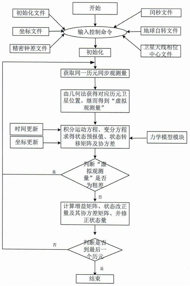
The invention relates to a ground receiver-based method for quickly finding and determining the orbit of navigation satellites. The steps are as follows: the ground receiver first searches and stores all visible satellites; uses the latest almanac, roughly estimates the user's position and speed, Searching for the estimated GPS time; in the next satellite search, the ground receiver determines the satellites within the field of vision for fast star searching; determines the satellite position corresponding to the epoch; obtains the virtual observation amount; completes the data processing, The optimal estimate of the satellite state is given; the present invention uses the ground receiving point of the ground receiver, the signal sent by the joint navigation satellite and the information stored in the ground receiver to receive and calibrate the satellite signal, and according to the calculated carrier wave The phase ambiguity is used for parameter estimation, which improves the success rate of carrier phase ambiguity resolution, effectively reduces the invalid search range and time, and further improves the fast star-finding ability and the orbit determination accuracy of navigation satellites.

Description

technical field [0001] The invention belongs to the field of satellite communication, and relates to a method for fast satellite search and orbit determination of a navigation satellite based on a ground receiver. Background technique [0002] my country's rail business started in the 1990s. Various aspects involved in the orbit mechanics of artificial earth satellites, including perturbation motion equations and solutions, transformation theory, perturbation force model, post-Newton effect, orbit improvement methods, etc.; deduced many key formulas, combining theory with precise orbit determination software , developed orbit calculation software; navigation satellites carried out real-time orbit and clock determination. In recent years, more and more research institutions in my country have joined the ranks of Beidou Data Analysis Center. [0003] By the end of 2012, my country had launched 14 Beidou navigation satellites, including 5 GEO satellites, 5 IGSO satellites, an...

Claims


Application Information

Patent Timeline
Patent Type & Authority Patents(China)
IPC IPC(8): G01S19/24
CPCG01S19/24
Inventor 胡静关新锋张斯炜栾金金郭文军郭荣刘永刚
Owner SPACE STAR TECH CO LTD
Learn More