
Unmanned aerial vehicle flight control method and system for plant protection based on farmland image feature identification

A plant protection UAV and image feature technology, applied in the field of plant protection UAV flight control, can solve the problems of ground remote control that is difficult to accurately control flight, cumbersome, inconvenient, etc., to achieve automatic recognition of farmland boundaries, improve efficiency, and save time.

Inactive Publication Date: 2018-01-26
合肥嘉浓航空科技有限公司
View PDF5 Cites 11 Cited by
  • Summary
  • Abstract
  • Description
  • Claims
  • Application Information

AI Technical Summary

Problems solved by technology

[0003] However, there are inconveniences in the above-mentioned various flight control methods: it is difficult to accurately control the flight in an area far away from the controller by remote control on the ground; Recognition technology to study the precise navigation of plant protection UAVs is a differentiated highlight in the UAV market competition at this stage, and it is also an effective technical means to improve the efficiency and reliability of UAVs

Method used


Image

  • Unmanned aerial vehicle flight control method and system for plant protection based on farmland image feature identification
  • Unmanned aerial vehicle flight control method and system for plant protection based on farmland image feature identification

Examples


Embodiment Construction

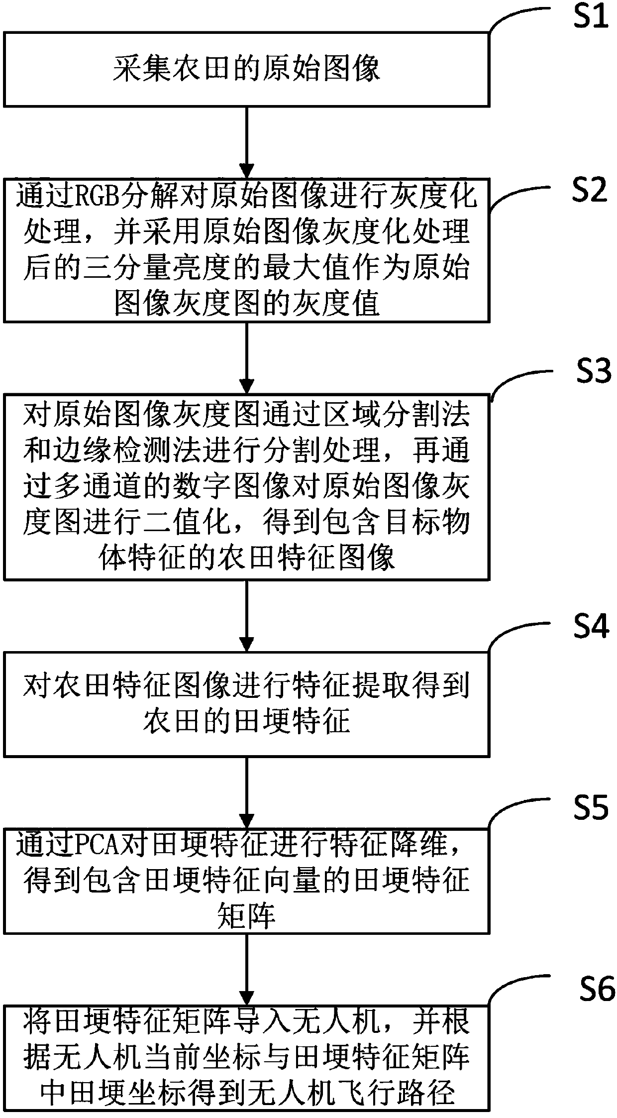
[0028] refer to figure 1 , a plant protection UAV flight control method based on farmland image feature recognition proposed by the present invention, including:

[0029] Step S1, collecting the original image of the farmland;

[0030] In this embodiment, the original image of the preset farmland is collected by drone shooting or high-altitude shooting.

[0031] Step S2, performing grayscale processing on the original image through RGB decomposition, and adopting the maximum value of the three-component brightness after grayscale processing of the original image as the grayscale value of the grayscale image of the original image;

[0032] In this step, before performing grayscale processing on the original image through RGB decomposition, it also includes: scaling the original image, and adjusting the original image to a standard size;

[0033] In this embodiment, since the size of the farmland is different, and the size of the original image is different when collecting the...


PUM


Abstract

The invention discloses an unmanned aerial vehicle flight control method and system for plant protection based on farmland image feature identification. The method includes the following steps: acquiring an original image of a farmland; performing gray processing on the original image through RGB analysis, taking the maximums of the brightness of three components after the original image undergoesgray processing as the gray values of the gray scale image of the original image; segmenting the gray scale image of the original image by using a regional segmentation method and an edge detection method, then performing binaryzation on the gray scale image of the original image through a multi-channel digital image, obtaining a farmland feature image which contains the features of a target object; extracting the features from the farmland feature image, obtaining the ridge features of the farmland; performing feature dimension reduction on the ridge features through the PCA, obtaining a ridge feature matrix which contains a ridge feature vector; and introducing the ridge feature matrix to an unmanned aerial vehicle, and based on the current coordinate of the unmanned aerial vehicle andthe coordinate of the ridge in the ridge feature matrix, obtaining a flight path of the unmanned aerial vehicle.

Description

technical field [0001] The invention relates to the field of unmanned aerial vehicle flight control technology, in particular to a plant protection unmanned aerial vehicle flight control method and system based on farmland image feature recognition. Background technique [0002] With the development of my country's agricultural industrialization process, the plant protection drone industry is booming to improve the level of agricultural technology equipment and informatization, accelerate agricultural mechanization, develop smart agriculture, and improve agricultural productivity. The flight control system is one of the core technologies of the UAV. The existing flight control system is mainly controlled by the operator through the ground remote control, GPS positioning and sensor feedback. [0003] However, there are inconveniences in the above-mentioned various flight control methods: it is difficult to accurately control the flight in an area far away from the controller ...

Claims


Application Information

Patent Timeline
Patent Type & Authority Applications(China)
IPC IPC(8): G06K9/00G06K9/34G06K9/62G06Q10/04
Inventor 徐海明胡鉴
Owner 合肥嘉浓航空科技有限公司
Learn More