Method for rapidly generating agile imaging satellite earth observation requirement plans

An imaging satellite, earth observation technology, applied in special data processing applications, instruments, electrical digital data processing, etc., can solve the complexity of planning problems and increase the difficulty of optimization, increase the space for feasible solutions, and increase the working mode of satellites and other problems to achieve the effect of reducing the amount of logical operations, reducing the complexity of the problem, and reducing the scale of the problem

Active Publication Date: 2017-12-19
10TH RES INST OF CETC
View PDF8 Cites 5 Cited by
  • Summary
  • Abstract
  • Description
  • Claims
  • Application Information

AI Technical Summary

Problems solved by technology

The demand planning problem of agile imaging satellite is a typical resource-constrained mission planning problem, because for an agile imaging satellite, its orbit, attitude maneuverability, payload capacity and other resource conditions are relatively fixed, and the agile Imaging satellites can only meet limited observational needs on the basis of these limited resources
The traditional single-satellite imaging planning method can no longer meet the actual needs, and the satellite earth observation mission planning is gradually changing from relying on the manual preparation of ground personnel to on-board autonomous plan generation, from single-satellite self-contained system management to multi-satellite formation or formation. Constellation Network Management
[0009] The satellite demand planning problem itself belongs to a kind of NP-hard problem, and because of its stronger earth observation ability, the agile imaging satellite has greatly increased the working mode of the satellite's observation, and the space for the feasibility of the mission has increased significantly. The complexity of the planning problem and the difficulty of optimization are greatly increased

Method used


Image

  • Method for rapidly generating agile imaging satellite earth observation requirement plans
  • Method for rapidly generating agile imaging satellite earth observation requirement plans
  • Method for rapidly generating agile imaging satellite earth observation requirement plans

Examples


Embodiment Construction

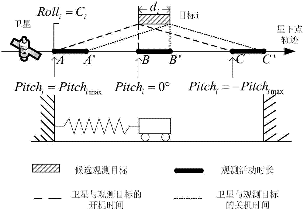
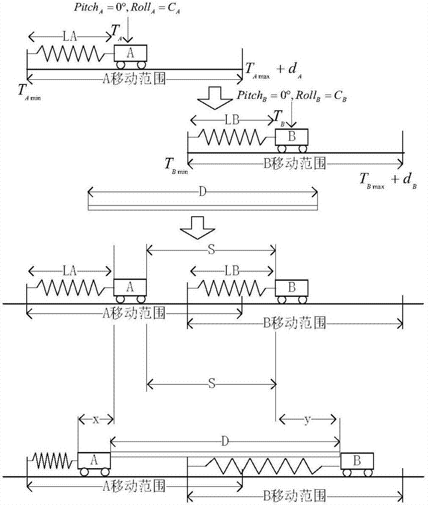
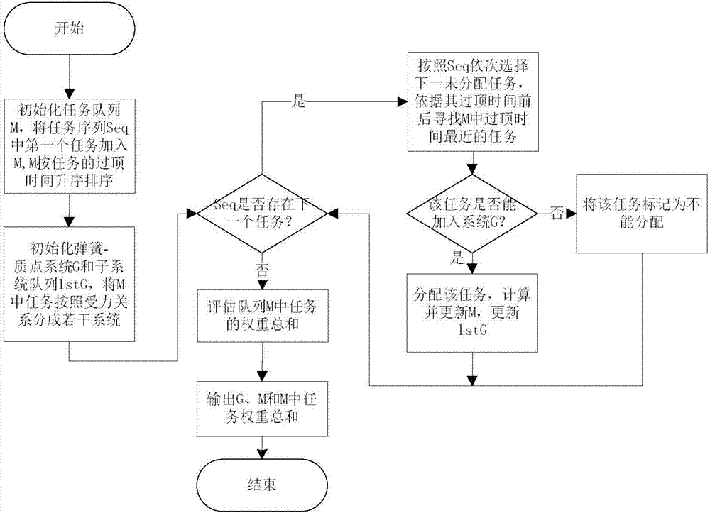
[0024] refer to figure 1 , figure 2 , image 3 . According to the present invention, (1) establish a spring-mass system model: the agile imaging satellite earth observation demand planning is abstracted into a spring-mass system, based on Hooke's law and force balance, it is established by a spring with a length L connected to the slider Spring-mass system model. The stiffness coefficient of each observation task is determined according to the geographical location of the observation target and the orbit of the satellite, and the relationship between the comprehensive angle of the agile imaging satellite's earth observation and the time difference between the observation time and the overhead time is abstracted as the elastic force and spring compression / tension in the spring-mass system The spring-mass system model is established based on the relationship between the lift length and the rest length of the spring, and the movable range and slider length of the mission slid...


PUM


Abstract

The invention discloses a method for rapidly generating agile imaging satellite earth observation requirement plans, and aims at providing a method for rapidly determining appointed satellite task observation time from an angle of enabling the whole imaging quality to be optimal. The method is realized through the following steps of: establishing a spring-particle system model on the basis of a Hooke's law and force balance; calculating constant machine time of each observation task and all the other observation tasks according to a geographic position of an observation object and maximum comprehensive angle observation ability of a satellite, so as to form a constant machine time matrix; sorting the observation tasks, adding the observation tasks into a spring-particle system in sequence, calculating a position of each task sliding block when the spring-particle system keeps a force balance state after each observation task joins by applying a satellite attitude mobility table and the constant machine time matrix, obtaining an optimal observation time of each task, and generating an agile imaging satellite earth observation requirement planning scheme.

Description

technical field [0001] The invention relates to a demand planning method for agile imaging satellites in the field of aerospace demand planning, in particular to a modeling method and an implementation method based on Hooke's law and force balance to support intelligent optimization of planning schemes and to quickly generate planning schemes. Background technique [0002] With the continuous improvement of imaging satellite application requirements, the imaging satellite platform and payload technology are also constantly developing. The high-resolution agile imaging satellite is a new generation of advanced satellite designed and developed according to the future satellite application requirements and technology development trends. It is a kind of earth observation satellite with large-scale and fast maneuverability. While improving the efficiency of satellite observation, agile imaging satellites also make the planning and scheduling of satellite requirements more complex...

Claims


Application Information

Patent Timeline
IPC IPC(8): G06F17/50
CPCG06F30/20
Inventor 宋竹
Owner 10TH RES INST OF CETC
Why Eureka
Try Eureka