Satellite-borne SAR target location precision index ground assessment method

A technology for target positioning and positioning accuracy, applied in radio wave measurement systems, instruments, etc., to achieve the effect of clear process, improved accuracy, and easy implementation

Active Publication Date: 2017-10-27
SHANGHAI SATELLITE ENG INST
View PDF0 Cites 5 Cited by
  • Summary
  • Abstract
  • Description
  • Claims
  • Application Information

AI Technical Summary

Problems solved by technology

The above research is limited to the analysis of individual error factors that affect the positioning accuracy, and the complete method and process of the target positioning accuracy index design, budget and simulation evaluation, as well as the Monte Carlo simulation method based on orbital simulation data, have not yet been seen. arrive

Method used


Image

  • Satellite-borne SAR target location precision index ground assessment method
  • Satellite-borne SAR target location precision index ground assessment method
  • Satellite-borne SAR target location precision index ground assessment method

Examples


Embodiment 1

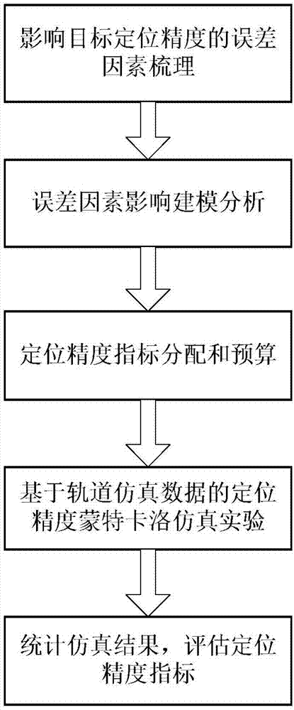
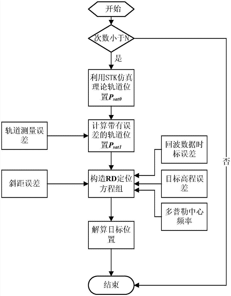
[0073] Below in conjunction with accompanying drawing and specific embodiment the present invention is described in further detail:

[0074] Here, the sun-synchronous orbit X-band space-borne SAR is selected to study the ground evaluation method of target positioning accuracy. The space-borne SAR orbit height is about 627km, the incident angle is 45°, and the target point elevation is 0m. X-band refers to the radio wave band with a frequency of 8-12GHz, which belongs to microwave in the electromagnetic spectrum.

[0075] The error values ​​are as follows: the Doppler center frequency error is 100Hz, the orbit position measurement accuracy is 10m (1σ), the velocity measurement error is 0.06m / s, the slope distance error is 3m (1σ), and the control point elevation error is 50m (1σ) , the time scale error of the echo data is 10ms.

[0076] According to the error impact model in step 2, the error is modeled and analyzed.

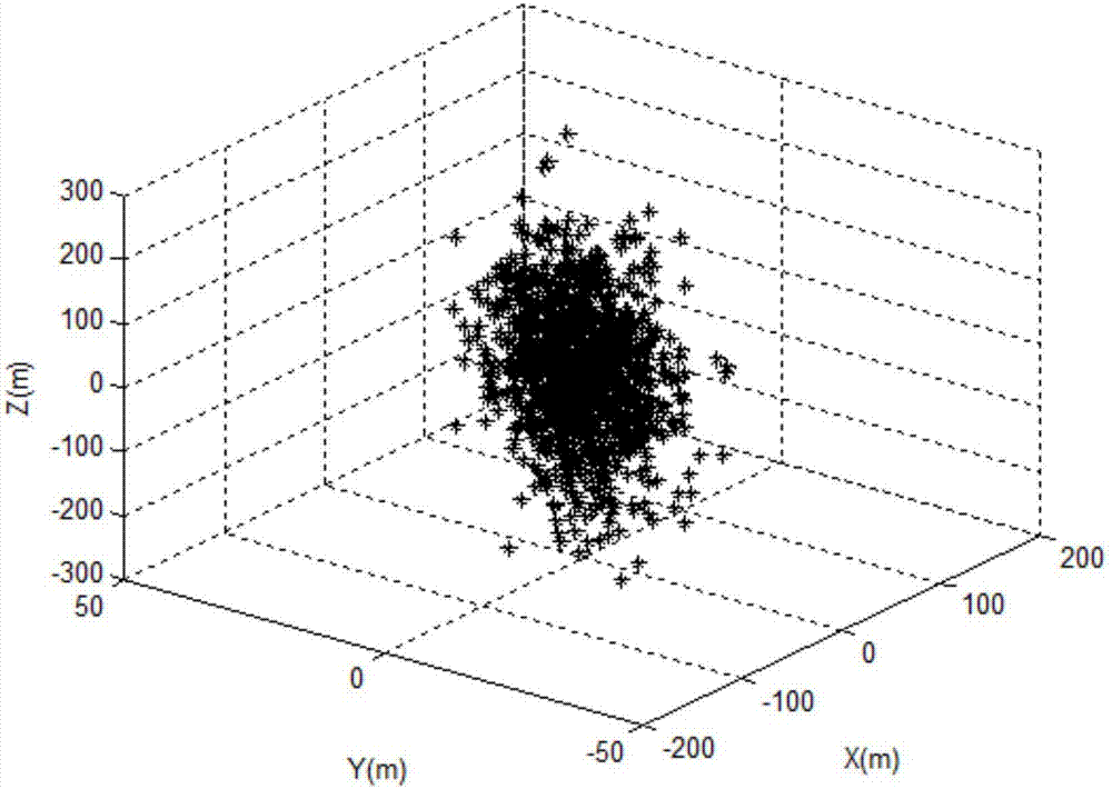
[0077] The error is allocated and budgeted, and the resul...


PUM


Abstract

The invention discloses a satellite-borne SAR target location precision index ground assessment method, and the method comprises the following steps: 1, sorting error factors which affect the target location precision; 2, carrying out the analysis of the impact on modeling from error factors; 3, carrying out the distribution and budgeting of location precision indexes; 4, carrying out the Monte Carlo simulation test of the location precision based on orbit simulation data; 5, carrying out the statistics of a simulation result, and estimating the location precision indexes. The invention firstly proposes the brand-new satellite-borne SAR target location precision ground assessment method and flow, and is innovative. In particular, the invention proposes a Monte Carlo simulation method for verifying the target location precision, and the Monte Carlo simulation method improves the accuracy of location precision estimation. The method provided by the invention is clear in flow, is easy to implement, and achieve a guide effect for a general designer for a satellite-borne SAR system.

Description

technical field [0001] The invention relates to a ground evaluation method for a target positioning accuracy index, in particular to a ground evaluation method for a spaceborne SAR target positioning accuracy index. Background technique [0002] In 1951, Wiley discovered for the first time that side-looking radar can improve the azimuth resolution by using the Doppler frequency shift in the echo data signal. This milestone discovery marked the birth of Synthetic Aperture Radar (SAR) technology . Spaceborne synthetic aperture radar is an all-weather and all-weather active earth observation system, which has played an important role in land and resources census, surveying and mapping, disaster prevention and mitigation, etc. [0003] The application of SAR images needs to know the exact spatial position information of SAR images, but due to the position of the remote sensing imaging system, the error of the clock, as well as the influence of factors such as the space environm...

Claims


Application Information

Patent Timeline
Patent Type & Authority Applications(China)
IPC IPC(8): G01S7/40
CPCG01S7/40
Inventor 姜岩张久玲涂尚坦王海涛朱少杰叶兴彬
Owner SHANGHAI SATELLITE ENG INST
Why Eureka
Try Eureka