Multi-target route planning and united searching method of drone in urban low-altitude environment

A technology of path planning and unmanned aerial vehicles, which is applied to the control of finding targets, unmanned aircraft, motor vehicles, etc., can solve the problems of not using offline information, reducing flight time, etc., and achieve the goal of reducing storage capacity and computing performance Requirements, low computational complexity, cost reduction effect

Active Publication Date: 2017-07-21
BEIHANG UNIV
View PDF4 Cites 57 Cited by
  • Summary
  • Abstract
  • Description
  • Claims
  • Application Information

AI Technical Summary

Problems solved by technology

The problem is a multi-objective path planning problem
However, the above methods only solve the online path planning problem, they do not utilize offline information, i.e. geographic map information, to reduce the flight time

Method used


Image

  • Multi-target route planning and united searching method of drone in urban low-altitude environment
  • Multi-target route planning and united searching method of drone in urban low-altitude environment
  • Multi-target route planning and united searching method of drone in urban low-altitude environment

Examples


Embodiment Construction

[0033] The present invention will be further described below in conjunction with accompanying drawings and examples.

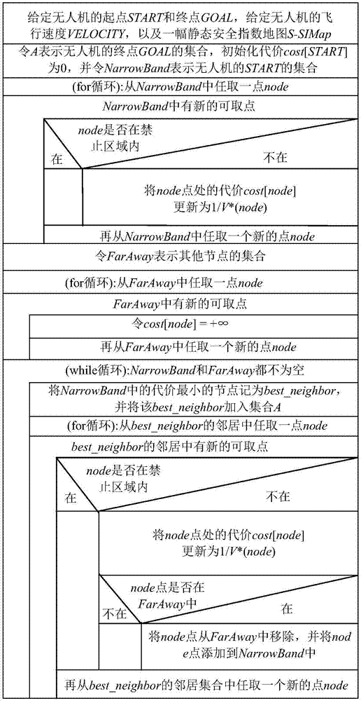
[0034] The multi-objective path planning problem to be solved by the present invention is: to find the Pareto optimal path for the unmanned aerial vehicle to fly over the dynamic urban low-altitude environment - which can not only ensure the safety of the unmanned aerial vehicle during flight, but also make the unmanned aerial vehicle Reach the destination in the shortest possible time. For this purpose, the present invention proposes two types of safety index maps, i.e. static safety index maps and dynamic safety index maps, which are marked with obstacles in geographic maps (such as Baidu maps) and UAVs during flight. Based on detected unmarked unknown obstacles. Based on this, the static cost distribution map and the dynamic cost distribution map are generated respectively, and a method based on the combination of offline search and online search based on ...


PUM


Abstract

The invention provides a multi-target route planning and united searching method of a drone in an urban low-altitude environment, and belongs to the technical field of drone route planning. The method comprises steps of firstly, based on a static-state known obstacle, constructing a static-state safe index map, and based on an obstacle which is actively detected by the drone in a flight process and is not marked in a geographical map, constructing a dynamic state safe index map on an airborne platform; and then, based on offline searching and online searching, solving and optimizing a multi-target route planning problem of flight time and flight safety of the drone in an united manner. According to the invention, a path costing little from a start point to a termination point is planned in an offline manner; when an unknown obstacle is detected, a changed flight track is planned in an online manner through online searching, so a dynamic obstacle is avoided; and there is a quite small searching space in the online searching, so a safe route can be planned again from the drone rapidly, so requirements on real-time planning of routes for drones are met.

Description

technical field [0001] The invention belongs to the technical field of UAV path planning, and specifically refers to a method for realizing UAV multi-target path planning in an urban low-altitude environment by combining offline and online searches. Background technique [0002] Since the U.S. Federal Aviation Administration (FAA) released the domestic unmanned aerial vehicles (UAVs) take-off and landing plan until 2015, the use of drones has received great attention. It is conceivable that in future smart cities (Smart Cities), drones will play an important role in logistics, emergency communications, firefighting, aerial photography, remote sensing, rescue and other affairs. In order to maximize the advantages of UAVs, the first thing to consider is how to make UAVs reach the designated area quickly and safely. This is the so-called Path Planning Problem. [0003] The path planning problem refers to the problem of solving one or more obstacle-free paths between the curren...

Claims


Application Information

Patent Timeline
Patent Type & Authority Applications(China)
IPC IPC(8): G05D1/12
CPCG05D1/12G08G5/0069G08G5/045G08G5/0039G08G5/0034G05D1/102B64U2201/00B64C39/024
Inventor 曹先彬肖振宇杨朋尹超席星吴大鹏
Owner BEIHANG UNIV
Why Eureka
Try Eureka