Data processing method of mountain area highway road test signal detection system

A road test and expressway technology, applied in the traffic control system of road vehicles, traffic flow detection, traffic control system, etc., can solve the problems of low data processing efficiency, low accuracy, lack of data collection, etc., and achieve data collection And the effect of high processing efficiency, high accuracy, and reducing human error

Inactive Publication Date: 2016-12-14
XIAN AERONAUTICAL UNIV
View PDF7 Cites 1 Cited by
  • Summary
  • Abstract
  • Description
  • Claims
  • Application Information

AI Technical Summary

Problems solved by technology

[0004] At present, the existing road test collection methods can collect relevant vehicle signals and the corresponding longitude, latitude and elevation of the signals, but it is difficult to correspond the longitude, latitude and other position information corresponding to the collected relevant signals to the chainage of the road alignment However, the item of road stake number is not displayed in the data output item
The existing technology is to manually process the data after collecting the data, and use the collected position information such as longitude and latitude to manually map it to the relevant road alignment stake number. This method is not only not accurate, but also has a high efficiency of data processing. At the same time, due to the loss of GPS signals when collecting highway tunnels in mountainous areas, the location signals such as latitude and longitude in the tunnel cannot be obtained, which will lead to the lack of data collection and bring great troubles to later research.
Generally speaking, the road test signals collected by the prior art all use the longitude and latitude information to correspond the collected signals, and it is rare to use the road stake number information for correspondence

Method used


Image

  • Data processing method of mountain area highway road test signal detection system

Examples


Embodiment Construction

[0039] The present invention will be further described below in conjunction with the accompanying drawings.

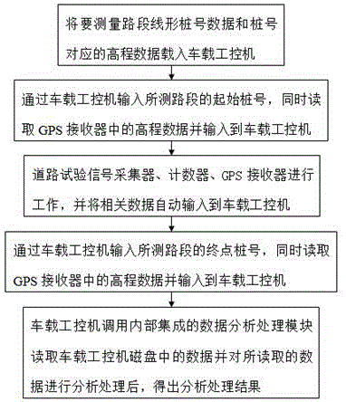
[0040] A data processing method of a mountainous expressway road test signal detection system, the system includes a road test signal collector, a counter, a GPS receiver and a vehicle-mounted industrial computer; the road test signal collector, the counter, and the GPS receiver are respectively and The vehicle-mounted industrial computer is wired or wirelessly connected through a data communication line or a wireless communication network; the road test signal collector is used to collect various road test signals required, and the road test signal collector can collect one signal or multiple signals , can be configured as required; the counter is used to count the number of signal groups collected by the road test signal collector, which is convenient for later calculation; the GPS receiver is used to receive elevation data; the interior of the vehicle-mounted industr...


PUM


Abstract

The present invention discloses a data processing method of a mountain area highway road test signal detection system. The method comprises the steps of loading the linear pile number data of a to-be-measured road section and the elevation data corresponding to the pile numbers in a vehicle-mounted industrial control computer; inputting the initial pile number of the measured road section via the vehicle-mounted industrial control computer, at the same time, reading the elevation data in a GPS receiver and inputting to the vehicle-mounted industrial control computer; enabling a road test signal acquiring device, a counter and the GPS receiver to work, and inputting the relevant data to the vehicle-mounted industrial control computer automatically; inputting the ending point pile number of the measured road section via the vehicle-mounted industrial control computer, at the same time, reading the elevation data in the GPS receiver and inputting to the vehicle-mounted industrial control computer; using the vehicle-mounted industrial control computer to call an internal integrated data analyzing and processing module to read the data in a magnetic disk of the vehicle-mounted industrial control computer, and analyze and process the read data to obtain the analysis and processing results. The data processing method of the present invention is high in data processing efficiency and data accuracy, enables the personal errors to be reduced effectively, and saves the manpower and material resources.

Description

[0001] This application is a divisional application, the application number of the original application: 2015101995952, the application date: 2015-04-24, the name of the invention patent: a data processing method for a mountainous expressway road test signal detection system. technical field [0002] The invention relates to the technical field of data collection and processing, in particular to a data processing method for a road test signal detection system of a mountainous expressway. Background technique [0003] With the rapid and comprehensive development of the economy, my country's expressway construction has made great achievements. my country's geographical environment is extremely rich. In order to speed up the traffic roads connecting different regions, many mountainous expressways have been built in our country. The road environment of mountainous highways is complex and accidents occur frequently. Chinese researchers often do some road tests to collect relevant...

Claims


Application Information

Patent Timeline
Patent Type & Authority Applications(China)
IPC IPC(8): G08G1/01
CPCG08G1/01G08G1/0104G08G1/0125G08G1/0137
Inventor 王栋
Owner XIAN AERONAUTICAL UNIV
Why Eureka
Try Eureka