Method of identifying warm cloud precipitation rate based on Doppler radar information
A technology of Doppler radar and precipitation rate, which is applied in the field of meteorological information processing and estimation, can solve problems such as differences and improper use of Z-I relationship, and achieve the effect of reducing estimation errors and property losses
- Summary
- Abstract
- Description
- Claims
- Application Information
AI Technical Summary
Problems solved by technology
Method used
Image
Examples
Embodiment 1
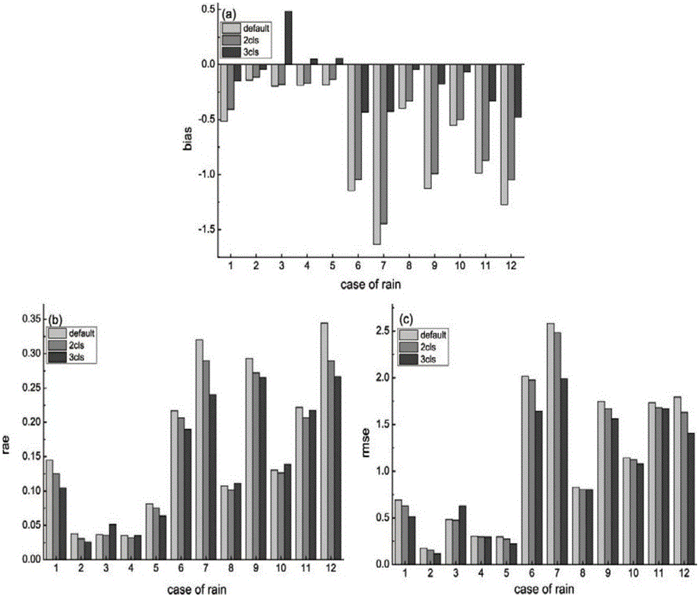
[0092] see figure 2 , 3 , in order to obtain a more accurate conclusion, the present invention counts the radar quantitatively estimated precipitation in Hefei from June to August in 2010, and evaluates the effect of each experiment through error analysis.
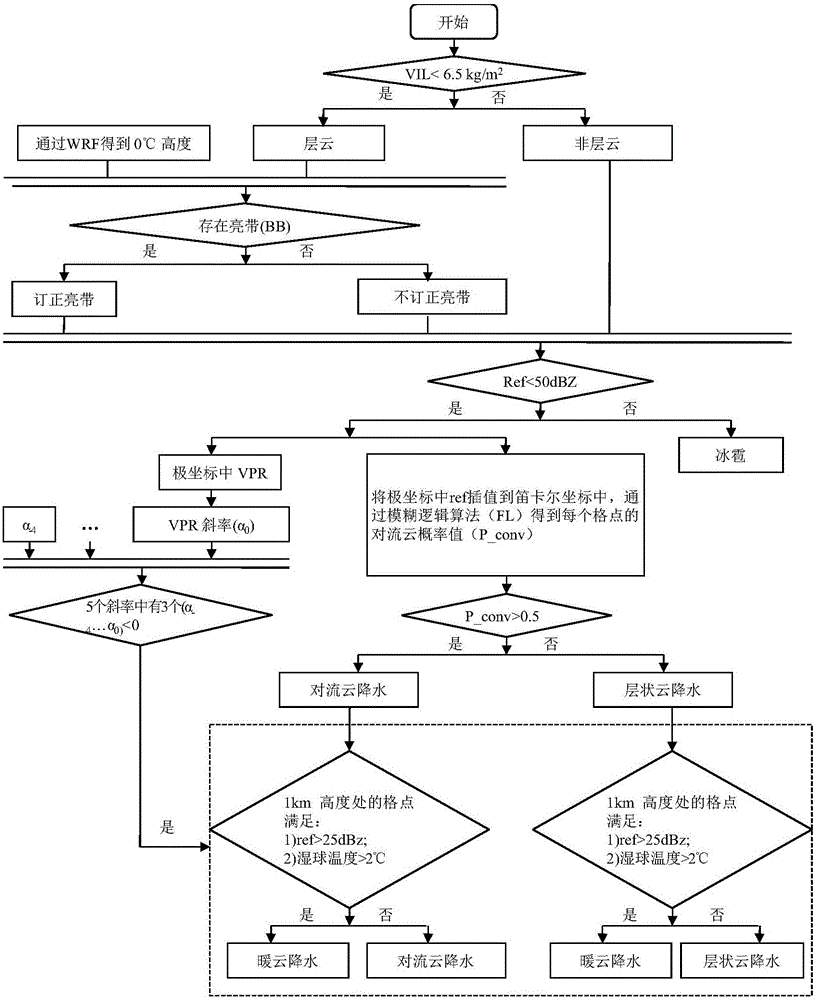
[0093] The radar data used in the present invention is obtained from the volume scan data of Hefei Doppler radar every 6 minutes from June to August 2010, and the observed precipitation data is obtained from the encrypted rainfall station in Anhui Province. The 0°C isotherm height h_0°C and the surface wet-bulb temperature are simulated by model WRF3.5.1. The initial boundary data are FNL data from June to August 2013, and the horizontal resolution is 1°×1°.
[0094] The radar quantitatively estimates the precipitation area from 115.758°E to 118.758°E and 30.367°N to 33.367°N, with 301×301 grid points in the horizontal direction and a grid spacing of 0.01° at the same longitude and latitude, and 73 floors in the vertical...
Embodiment 2
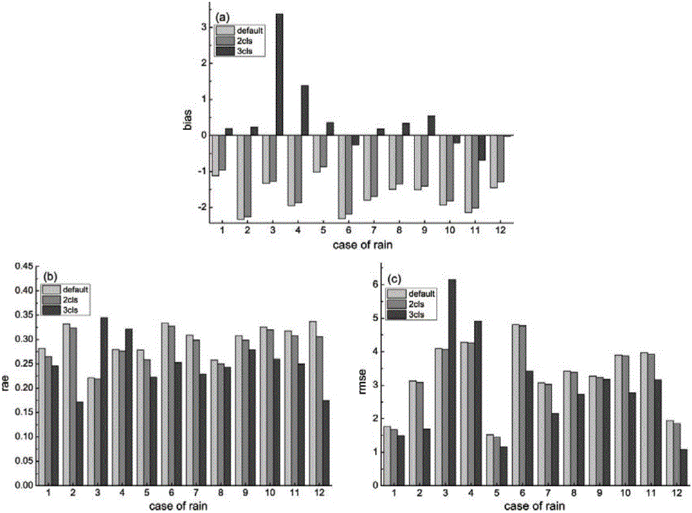
[0117]The method proposed in this chapter to divide precipitation into three types: warm cloud, stratiform cloud and convective cloud precipitation, what is the effect of radar quantitative estimation of precipitation when the precipitation area and precipitation time change? For this reason, this section selects two additional precipitation cases, and selects the heavy precipitation process in Anhui Province from July 21 to 23, 2009 to test the quantitative estimation of precipitation effects of the same radar in different periods; selects June 11 to 13, 2008 The process of heavy precipitation in Liuzhou, Guangxi tested the quantitative estimation of precipitation effect of different radars in different time periods.
[0118] The Liuzhou radar data is obtained from the Liuzhou Doppler radar volume scan data every 6 minutes, the radar model CINRAD / SB, the position (109.456°E, 24.357°N, 346.8m), 360° omnidirectional scanning, the interval is 1°, The scanning elevation angles ar...
PUM
 Abstract
Description
Claims
Application Information
 - R&D Engineer
- R&D Manager
- IP Professional
- Industry Leading Data Capabilities
- Powerful AI technology
- Patent DNA Extraction
Browse by: Latest US Patents, China's latest patents, Technical Efficacy Thesaurus, Application Domain, Technology Topic, Popular Technical Reports.
© 2024 PatSnap. All rights reserved.Legal|Privacy policy|Modern Slavery Act Transparency Statement|Sitemap|About US| Contact US: help@patsnap.com


