
Fire point processing method for transmission lines based on satellite data pictures

A transmission line and satellite data technology, applied in data processing applications, electrical digital data processing, special data processing applications, etc., can solve problems such as delays in transmission line fire prevention work, slow extraction speed, etc., to improve efficiency and ensure safe operation Effect

Active Publication Date: 2017-06-16
STATE GRID CORP OF CHINA +2
View PDF3 Cites 0 Cited by
  • Summary
  • Abstract
  • Description
  • Claims
  • Application Information

AI Technical Summary

Problems solved by technology

[0005] The invention provides a transmission line fire point processing method based on satellite data pictures to solve the technical problem that the traditional satellite data fire point extraction speed is slow and delays the transmission line fire prevention work

Method used


Image

  • Fire point processing method for transmission lines based on satellite data pictures
  • Fire point processing method for transmission lines based on satellite data pictures
  • Fire point processing method for transmission lines based on satellite data pictures

Examples


Embodiment Construction

[0038] The embodiments of the present invention will be described in detail below with reference to the accompanying drawings, but the present invention can be implemented in many different ways defined and covered by the claims.

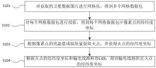
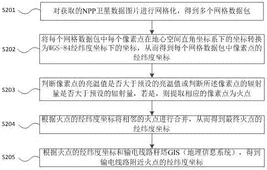
[0039] refer to figure 1 , a preferred embodiment of the present invention provides a method for processing transmission line fire points based on satellite data pictures, including:

[0040] Step S101, gridding the acquired satellite data pictures to obtain a plurality of grid data packets;

[0041] Step S102, projecting each grid data packet to obtain the latitude and longitude coordinates of the pixels in each grid data packet;

[0042] Step S103, extract the fire point according to the brightness temperature value or radiation amount of the pixel point, and obtain the longitude and latitude coordinates of the fire point;

[0043] Step S104, according to the latitude and longitude coordinates of the fire point and the transmission line tower GI...


PUM


Abstract

The invention discloses a transmission line fire point processing method and device based on satellite data pictures. The method obtains a plurality of grid data packets by gridding the acquired satellite data pictures; Projection to obtain the latitude and longitude coordinates of the pixels in each grid data packet; extract the fire point according to the brightness temperature value or radiation amount of the pixel point, and obtain the latitude and longitude coordinates of the fire point; according to the latitude and longitude coordinates of the fire point and the transmission line tower GIS, Obtain the latitude and longitude coordinates of the fire point near the transmission line, solve the technical problem of delaying the fire protection work of the transmission line caused by the slow extraction speed of the traditional satellite data fire point, realize the effective integration of satellite data reception, data subcontracting, and parallel processing, and improve the meteorological extreme. The processing speed of orbiting satellite data and the efficiency of mountain fire disaster response, and provide accurate information guidance for mountain fire prevention measures, so as to effectively guarantee the operation safety of the power grid.

Description

technical field [0001] The invention belongs to the technical field of electrical engineering, and in particular relates to a method for processing fire points of transmission lines based on satellite data pictures. Background technique [0002] Many provinces in my country are prone to wildfires in the continuous drought climate, especially during the high-incidence periods of industrial and agricultural fires such as spring plowing and Qingming period, it is very easy to break out large-scale wildfires, and the pollution or air discharge caused by the burning of wildfires near transmission lines will cause the line to trip. Affected by the long duration of wildfire burning, the environment of line tripping faults has always existed, and the automatic reclosing of lines is difficult to succeed, which may easily cause long-term power outages and cause severe impacts. Taking 2013 as an example, wildfires caused failures of multiple transmission lines in the power system, and ...

Claims


Application Information

Patent Timeline
Patent Type & Authority Patents(China)
IPC IPC(8): G06F17/50G06Q50/06
Inventor 陆佳政罗晶方针李波张红先赵纯
Owner STATE GRID CORP OF CHINA
Learn More