Eureka AIR delivers breakthrough ideas for toughest innovation challenges, trusted by R&D personnel around the world.

Low-altitude rescue aircraft route planning method based on three dimensional airspace grids

A trajectory planning, three-dimensional airspace technology, applied in the direction of instrumentation, forecasting, electronic digital data processing, etc., can solve problems such as not considering multi-aircraft flight conflicts, rarely considering safe flight rules, rescue rules and aircraft performance constraints, etc., to achieve The effect of improving safety and efficiency

Inactive Publication Date: 2015-10-21
NANJING UNIV OF AERONAUTICS & ASTRONAUTICS
View PDF2 Cites 60 Cited by
  • Summary
  • Abstract
  • Description
  • Claims
  • Application Information

AI Technical Summary

Problems solved by technology

However, there are some problems in the application of the existing research to the trajectory planning of aviation rescue: ① most methods only solve the problem of path planning in the two-dimensional plane; ② the three-dimensional trajectory planning in UAV flight mainly uses altitude The correction method rarely considers safe flight rules, rescue rules and aircraft performance constraints; ③ most of the solutions are single aircraft trajectory planning problems, and the flight conflicts between multiple aircraft are not considered

Method used


Image

  • Low-altitude rescue aircraft route planning method based on three dimensional airspace grids
  • Low-altitude rescue aircraft route planning method based on three dimensional airspace grids
  • Low-altitude rescue aircraft route planning method based on three dimensional airspace grids

Examples


Embodiment Construction

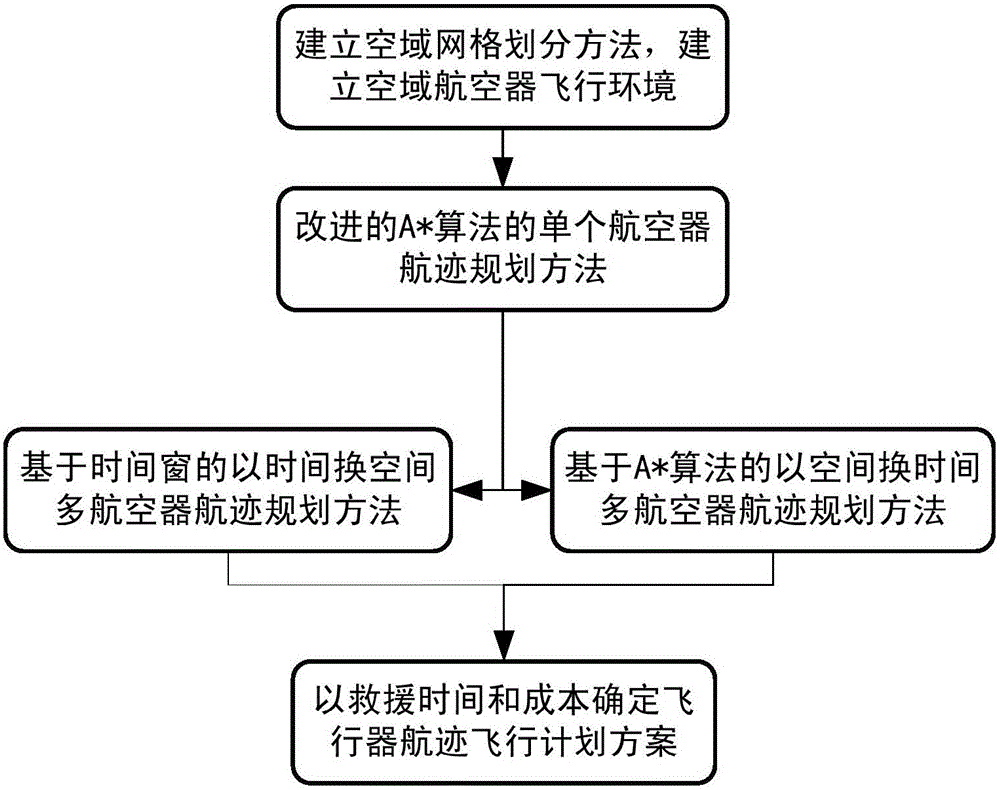
[0046] Please refer to figure 1 As shown, the low-altitude rescue aircraft trajectory planning method based on the three-dimensional airspace grid of the present invention includes the following steps:

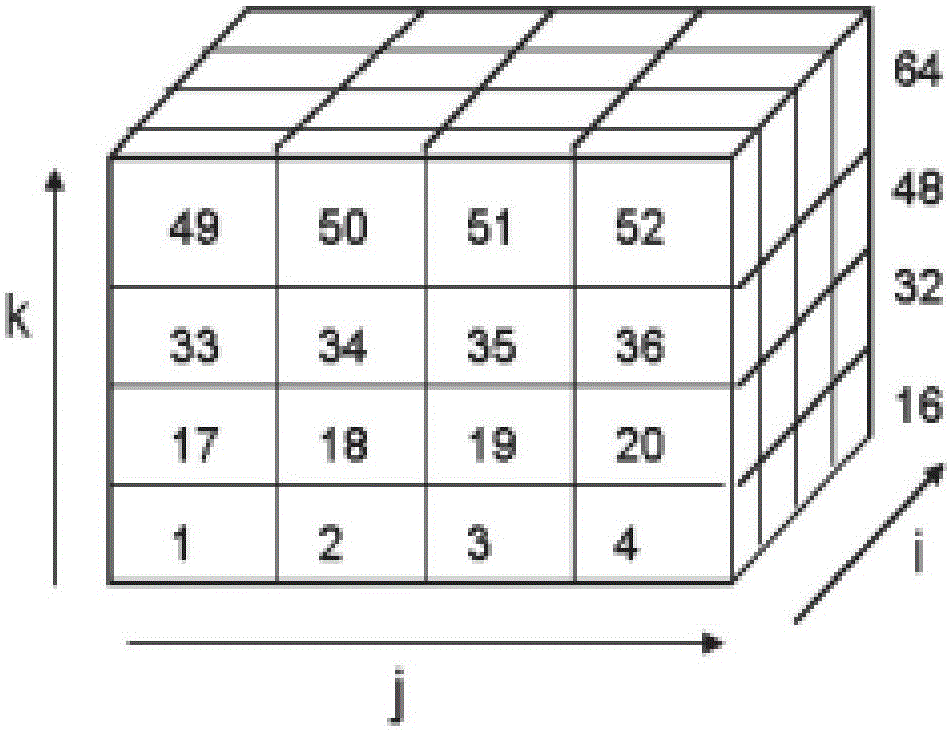
[0047] Step 1. Establish airspace grid division and determine the airspace aircraft flight environment;

[0048] Step 2: Determine the single aircraft trajectory planning of the improved A* algorithm;

[0049] Step 3. Multi-aircraft conflict-free strategic trajectory planning.

[0050] Step 2 includes:

[0051] Step 21: Read the aircraft information and create an openlist table for it. Initialize it to include only the initial node, that is, the node where the rescue point is in the airspace grid; create a closelist table and initialize it to empty; set g(1)=0. Among them, g(n) is the cost from the starting point (node ​​1) to the current node (node ​​n), w m (n) is the weight function: g ( n ) = g ( n - 1 ) + d i s t ( n , n - 1 ) ...


PUM


Abstract

The invention discloses a low-altitude rescue aircraft route planning method based on three dimensional airspace grids. The low-altitude rescue aircraft route planning method comprises that according to the three dimensional terrain, the aircraft performance and the weather distribution, the low-altitude airspace is divided into grids, nodes are generated, and the optimal flight path of a single aircraft is searched by means of an improved A* algorithm; on the basis that the flight path of the single aircraft is determined, by means of a time window estimation method, a time-space-interchange multi-aircraft conflict-free route planning method is provided, finally the shortest rescue time is taken as the optimization object, and a multi-aircraft conflict-free route planning scheme is obtained. According to the invention, an aviation rescue multi-aircraft conflict-free route planning method which takes the low-altitude complex terrain, the weather distribution and the aircraft performance into account, and a basis can be provided for the arrangement of the aircraft flight plan of an aviation emergency rescue command system.

Description

Technical field: [0001] The invention relates to a flight scheduling technology for aviation rescue, in particular to a low-altitude rescue aircraft trajectory planning method based on a three-dimensional airspace grid, which is suitable for aircraft optimization scheduling and flight plan scheduling under low-altitude rescue, ensuring air traffic operation Safe and efficient. Background technique: [0002] Among the various measures for disaster relief and emergency handling, aviation rescue has the advantages of being fast, efficient, and less restricted by geographical space, and is the most effective means commonly used by many countries in the world. However, in the aviation emergency rescue system, in the low-altitude operating environment of the rescued aircraft, due to the interference of the terrain environment, bad weather, dense flight and other uncertain factors, there are often high safety risks, low rescue efficiency and unreasonable implementation. And other issue...

Claims


Application Information

Patent Timeline
Patent Type & Authority Applications(China)
IPC IPC(8): G06F17/30G06Q10/04
CPCG06F16/2453G06Q10/047Y02A90/10
Inventor 张明王磊王硕喻慧李翔宇
Owner NANJING UNIV OF AERONAUTICS & ASTRONAUTICS
Why Eureka
Eureka Blog
Learn More