
Automatic vehicle-mounted three-dimensional laser point cloud facade classification and outline extraction method

A three-dimensional laser, contour line technology, applied in image analysis, the use of optical devices, image data processing, etc., to reduce the collection workload, save production costs, and fully automate the processing process.

Active Publication Date: 2015-05-27
WUHAN HI TARGET DIGITAL CLOUD TECH CO LTD
View PDF3 Cites 17 Cited by
  • Summary
  • Abstract
  • Description
  • Claims
  • Application Information

AI Technical Summary

Problems solved by technology

[0004] However, at present, in China, building facade detection technology has not been widely used in Internet street views. The most important reason is that there is no good method to quickly extract building facades.

Method used


Image

  • Automatic vehicle-mounted three-dimensional laser point cloud facade classification and outline extraction method
  • Automatic vehicle-mounted three-dimensional laser point cloud facade classification and outline extraction method
  • Automatic vehicle-mounted three-dimensional laser point cloud facade classification and outline extraction method

Examples


Embodiment 1

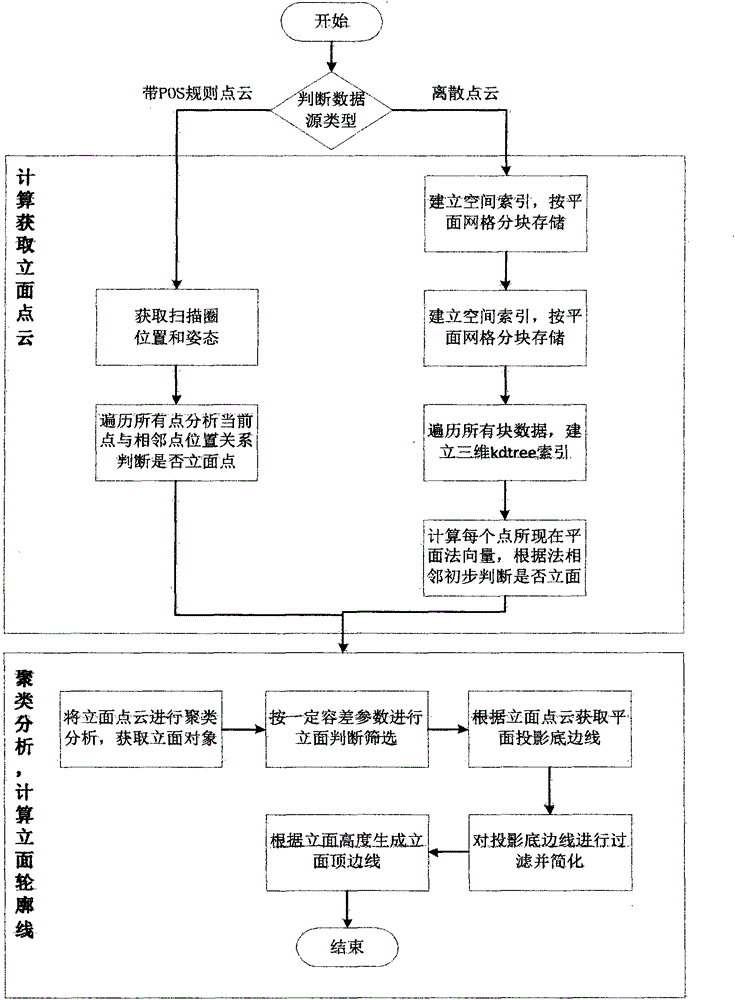
[0032] The implementation of including POS trajectory data involves two input data sources, namely POS trajectory and point cloud data.

[0033] I Among them, the POS trajectory is the time, position and posture of each scanning circle scanning time during the vehicle driving process, including: year, month, day, hour, minute, second, millisecond, longitude, latitude, Gaussian projection coordinates XYZ.

[0034] The point cloud data is stored in circles according to the scanning order, and the file header contains basic data and circle index data. The method steps used are as follows:

[0035] (1) Traverse all circles of the point cloud and obtain the POS coordinate P of the current circle 0 (X p0 , Y p0 ,Z p0 ). Traverse all the points in the current circle and calculate the current point P(X p , Y p ,Z p ) To P 0 The distance D. According to the distance D and the angular resolution θ, calculate the spherical theoretical distance D s . Get a total of 4 points before and after t...

Embodiment 2

[0047] For discrete point cloud data, first divide the point cloud data into a plane grid, store it in blocks and establish a block index, then traverse the point cloud data in blocks, calculate the normal vector of each point, and judge whether it is a facade according to the normal vector point.

[0048] The specific implementation steps are as follows:

[0049] (1) Calculate the spatial range of the disordered discrete point cloud, divide the grid according to the spatial range and the amount of point cloud data to ensure that the number of points of the divided point cloud does not exceed 10,000, and establish the LOD spatial index.

[0050] (2) Traverse all the point cloud blocks and establish a three-dimensional kdtree index for the point cloud blocks. Traverse each point in the block, find the nearest N points according to the kdtree index (default 128), and calculate the normal vector by fitting the plane to the nearby N points. If the angle between the normal vector and the...


PUM


Abstract

The invention relates to an automatic vehicle-mounted three-dimensional laser point cloud facade classification and outline extraction method which comprises the following steps: (1) acquiring corresponding position and posture of a three-dimensional laser scanner at each scanning ring; (2) calculating the position relationship of adjacent points under theoretic vertical condition according to the position and the angular resolution of the scanner; (3) performing clustering analysis on facade points, thereby obtaining a building facade object list; (4) analyzing each facade object, screening, and excluding objects which do not belong to the building facade; (5) sequencing point cloud of each facade object in the length direction of the bottom side of the an outer box, and constructing a planar projection line object; (6) screening planar projection lines; (7) simplifying the planar projection lines, thereby obtaining a final projection line. Through the adoption of the method, facade point cloud and facade outline can be rapidly extracted, the processing process can be completely automatic without artificial interference, the facade acquisition workload in streetscape data production is greatly reduced, and the production cost is reduced.

Description

Technical field [0001] The invention relates to an automatic method for vehicle-mounted three-dimensional laser point cloud elevation classification and contour line extraction, and belongs to the technical field of three-dimensional laser movement measurement. Background technique [0002] At present, 3D lasers, street view images, and indoor images have been rapidly popularized and applied. The applications involved include Internet / mobile Internet real-world maps, digital urban management, smart cities, geographic national conditions surveys, and traditional DLG (digital line drawing) data collection. [0003] On the Google Street View image, the mouse is placed on the facade of the building, which has a surface exploration effect. Clicking on the facade with the mouse can quickly jump and locate and browse, which greatly improves the user's experience of browsing the street view. This technology is realized because it is supported by facade patches based on 3D laser point cloud...

Claims


Application Information

Patent Timeline
Patent Type & Authority Applications(China)
IPC IPC(8): G06T7/00G06K9/46G01B11/00
CPCG06T2207/10028
Inventor 龚书林刘守军
Owner WUHAN HI TARGET DIGITAL CLOUD TECH CO LTD
Learn More