Eureka AIR delivers breakthrough ideas for toughest innovation challenges, trusted by R&D personnel around the world.

Construction positioning display method and construction positioning display system based on geographic information of nuclear power plant

A technology of geographic information and display system, which is applied in the field of construction positioning display method and system based on geographic information of nuclear power plants, to achieve the effects of reducing damage rate, improving analysis steps and time, and improving construction efficiency

Inactive Publication Date: 2015-04-29
中广核工程有限公司 +1
View PDF5 Cites 3 Cited by
  • Summary
  • Abstract
  • Description
  • Claims
  • Application Information

AI Technical Summary

Problems solved by technology

[0004] The technical problem to be solved by the embodiments of the present invention is to provide a construction positioning display method and system based on geographic information of nuclear power plants in view of the defects of construction positioning through ground-breaking certificates in the construction process of existing nuclear power plant sites

Method used


Image

  • Construction positioning display method and construction positioning display system based on geographic information of nuclear power plant
  • Construction positioning display method and construction positioning display system based on geographic information of nuclear power plant
  • Construction positioning display method and construction positioning display system based on geographic information of nuclear power plant

Examples


Embodiment Construction

[0043] The following will clearly and completely describe the technical solutions in the embodiments of the present invention with reference to the accompanying drawings in the embodiments of the present invention. Obviously, the described embodiments are only some, not all, embodiments of the present invention. Based on the embodiments of the present invention, all other embodiments obtained by persons of ordinary skill in the art without making creative efforts belong to the protection scope of the present invention.

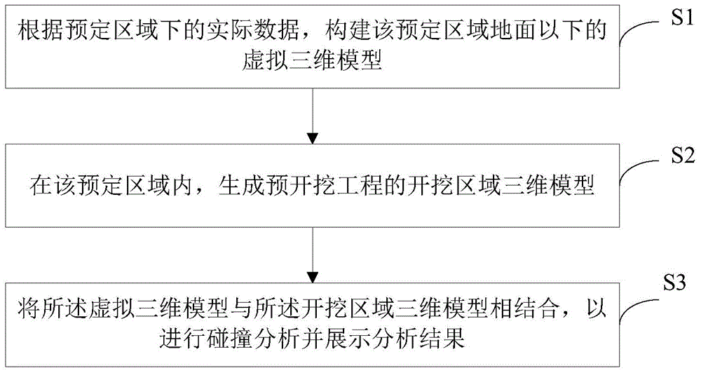
[0044] See Figure 1~5 . figure 1 It is a flow chart of the construction positioning display method based on the geographical information of the nuclear power plant according to the first embodiment provided by the present invention. In this embodiment, the construction positioning display method based on the geographic information of the nuclear power plant includes the following steps:

[0045] S1. Construct a virtual three-dimensional model below the grou...


PUM


Abstract

The invention discloses a construction positioning display method and a construction positioning display system based on geographic information of a nuclear power plant. The method includes: S1, creating a virtual three-dimensional model of an area below the surface of a preset area according to actual data of the area below the preset area; S2, in the preset area, creating a three-dimensional model of a digging area of a pre-digging project; S3, combining the virtual three-dimensional model with the three-dimensional model of the digging area to perform collision analysis and output and display an analysis result. The construction positioning display method and the construction positioning display system have the advantages through three-dimensional virtual restoration display of a scene of a nuclear power plant site, the digging area is positioned through geographical coordinates by a three-dimensional positioning function and space positions and trends of surrounding underground facilities are checked all-directionally; collision conditions of the digging area and the underground facilities are analyzed timely by the aid of a three-dimensional analyzing function; the underground facilities of the nuclear power plant site are visualized, professional requirements of professional engineers are lowered, analysis steps and time of the digging area are reduced, damage rate of the underground facilities is reduced, and construction efficiency of the nuclear power plant site is improved.

Description

technical field [0001] The invention relates to the technical field of nuclear power, in particular to a construction location display method and system based on geographical information of nuclear power plants. Background technique [0002] In the construction process of nuclear power plant site engineering, land excavation and ground-breaking operations are carried out throughout. An intricate network of underground facilities consisting of various cables and pipelines will be laid underground in the nuclear power plant. These underground facilities are the basis for the construction of the nuclear power plant site. Excavation operations in the plant site may lead to damage to underground facilities at any time, resulting in the inability to work or construct in some areas of the construction site, thereby affecting the construction period of the entire nuclear power plant site. Due to the invisibility of various underground facilities in the ground-breaking area, there h...

Claims


Application Information

Patent Timeline
IPC IPC(8): G06T17/05
CPCG06T17/00
Inventor 宋波李丹常会杨帆罗亚林
Owner 中广核工程有限公司
Why Eureka
Eureka Blog
Learn More