
Texture-based method of calculating index of building zone of high-resolution remote sensing image

A high-resolution, remote sensing image technology, applied in computing, computer components, image analysis, etc., can solve the problems of difficulty in solving model parameters, difficult multi-scale analysis, limited application scope, etc. Accuracy and high extraction precision

Active Publication Date: 2013-10-09
WUHAN UNIV
View PDF3 Cites 6 Cited by
  • Summary
  • Abstract
  • Description
  • Claims
  • Application Information

AI Technical Summary

Problems solved by technology

The statistical method calculates the relatively stable statistical value in the local area of ​​the image as the texture feature, such as the gray level co-occurrence matrix. This type of method is simple to calculate and easy to implement, but it is difficult to perform multi-scale analysis; the structural method believes that the complex texture is composed of texture Primitives are arranged according to certain spatial rules. The key lies in the determination and extraction of texture primitives and the definition of arrangement rules between texture primitives, such as Tamura texture features. This type of method is more suitable for artificial textures with strong regularity. The scope is relatively limited; the model method believes that the texture is a random distribution model controlled by certain parameters, and the texture features are generally extracted by estimating the parameters of the model, such as the Markov random field model. This type of method can be applied to multi-scale texture analysis, but The parameters of the model are difficult to solve and the amount of calculation is high; the method based on the time / frequency domain first uses a certain filtering method to filter the image to obtain different frequency and direction subbands, and then performs local energy function calculations to obtain multiple subbands Integrating and smoothing to obtain image texture features

Method used


Image

  • Texture-based method of calculating index of building zone of high-resolution remote sensing image
  • Texture-based method of calculating index of building zone of high-resolution remote sensing image
  • Texture-based method of calculating index of building zone of high-resolution remote sensing image

Examples


Embodiment Construction

[0022] In order to better understand the technical solution of the present invention, the present invention will be further described in detail below in conjunction with the accompanying drawings and embodiments.

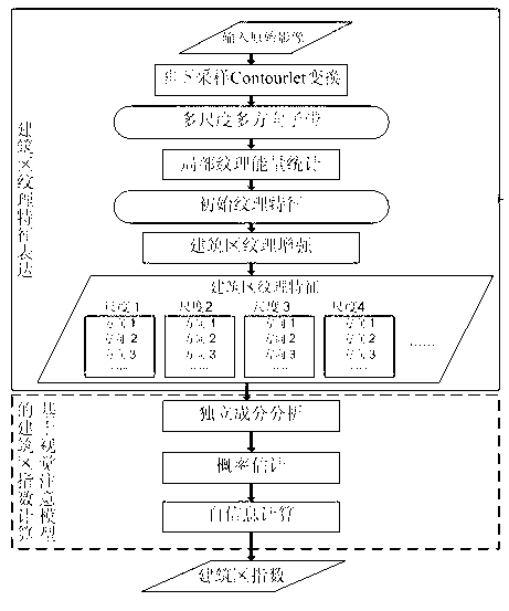
[0023] please see figure 1 , the technical scheme adopted in the present invention is: a kind of calculation method of the building area index of high-resolution remote sensing image based on texture, it is characterized in that, comprises the following steps:

[0024] Step 1: Calculate the grayscale image of the original image, and perform non-subsampled Contourlet transformation on the grayscale image to obtain multi-scale and multi-directional high-frequency subband coefficients;

[0025] The non-subsampling Contourlet transform can decompose the image in multiple scales and directions. The process is mainly divided into two steps: first, the image is divided into low-frequency subbands and multi-scale high-frequency subbands with a non-subsampling pyramid struct...


PUM


Abstract

The invention discloses a texture-based method of calculating an index of a building zone of a high-resolution remote sensing image. The method comprises the following steps that NSCT conversion is conducted on the image, multi-scale and multi-directional sub-band coefficients are formed, partial texture energy of each sub-band coefficient is counted, building zone texture enhancement calculation is conducted on the partial texture energy to make characteristics of the building zone stand out, visual saliency is defined from the perspective of information theory, the index of the building zone is generated by adopting a visual attention mechanism based on self-information maximization, and the larger the index is, the higher significance the building zone has in a human vision process. According to the texture-based method of calculating the index of the building zone of the high-resolution remote sensing image, the characteristics of the building zone in the high-resolution remote sensing image are taken into consideration fully, multi-scale and multi-directional textural features of the building zone are built, the index is calculated according to a visual attention process to describe the building zone, the index can describe the building zone intuitively, the good effect of extracting the building zone from the high-resolution remote sensing image is achieved, and extracting accuracy can also be guaranteed in a complex environment.

Description

technical field [0001] The invention belongs to the technical field of remote sensing image processing information extraction, and relates to a texture-based high-resolution remote sensing image building area index calculation method. Background technique [0002] Building areas are necessary information for research and analysis of land planning, post-disaster assessment, urban expansion, urban monitoring, and urban heat island, and are an important basis for population estimation, surveys, and urban planning. In order to improve research efficiency and reduce costs, extracting built-up areas from remote sensing images has become an important means of urban research. In addition, building area extraction is also an important auxiliary means to improve the efficiency of building extraction. Therefore, it is of great significance to extract built-up areas in remote sensing images. [0003] In the building area extraction algorithm, there is a kind of algorithm that extracts...

Claims


Application Information

Patent Timeline
IPC IPC(8): G06T7/00
CPCG06V20/176
Inventor 邵振峰田英洁沈小乐
Owner WUHAN UNIV
Learn More