Eureka AIR delivers breakthrough ideas for toughest innovation challenges, trusted by R&D personnel around the world.

A Calculation Method of Small Watershed Environmental Capacity Supported by GIS Technology

A technology of environmental capacity and calculation method, which is applied in the fields of calculation, general water supply saving, special data processing application, etc., can solve the problems of inaccurate capacity calculation results and inability to start, achieve a simple and practical scope of application, and achieve the effect of environmental protection

Active Publication Date: 2015-10-07
ZHENGZHOU UNIV
View PDF2 Cites 1 Cited by
  • Summary
  • Abstract
  • Description
  • Claims
  • Application Information

AI Technical Summary

Problems solved by technology

[0005] In view of the deficiencies in the existing small watershed water environment capacity calculation method, the technical problem to be solved in the present invention is to establish a new small watershed environmental capacity calculation method supported by GIS technology to determine the small watershed water environment capacity, which can not only overcome the When calculating the water environment capacity of small watersheds, it is difficult to start due to the lack of hydrological and other data, and it can also avoid the capacity calculation caused by not considering the impact of non-point sources or not considering the differences in the amount of non-point sources entering the river in each control unit If the results are not accurate enough, improving the accuracy of water environment capacity calculation is beneficial to the management of river ecological environment

Method used


Image

  • A Calculation Method of Small Watershed Environmental Capacity Supported by GIS Technology
  • A Calculation Method of Small Watershed Environmental Capacity Supported by GIS Technology
  • A Calculation Method of Small Watershed Environmental Capacity Supported by GIS Technology

Examples


Embodiment Construction

[0012] The specific implementation manners of the present invention will be described in detail below in conjunction with the accompanying drawings.

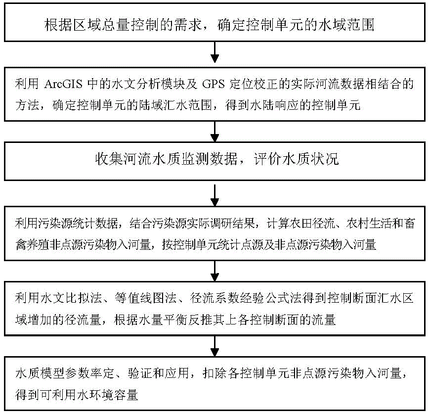
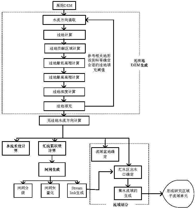
[0013] Depend on figure 1 As shown, the present invention is on the basis of determining the calculation and control unit of the water environment capacity of a small watershed, utilizes the hydrological analysis tool of ArcGIS software to carry out the river network extraction and watershed division of the digital elevation model data DEM, calculates the area of ​​the closed catchment area, and obtains water and land The corresponding control unit; then collect the water quality monitoring data of the river over the years, evaluate the water quality of the river, and analyze the trend of the water quality, and count the amount of point source and non-point source pollutants entering the river according to the control unit. For non-point source pollutants, it means For rural domestic pollutants, livestock and poultry breeding po...


PUM


Abstract

The invention relates to a method for calculating a small watershed environmental capacity under the support of GIS (Geographic Information System) technology. The problem of imprecise calculation result which is caused by the influence of a non-point source or the difference of river inlet quantity of the non-point source of each control unit is solved. The method comprises the following steps of determining the watershed range of the control unit; using a hydrologic analysis module in an ArcGIS software and the method of combining practical river data positioned and corrected by GPS (Global Position System) to determine the land area catchment range of the control unit so as to obtain the control unit for land and water response; evaluating the water quality status; using statistic data of a pollution source and combining the practical study result of the pollution source to summarize the pollutant river inlet quantity of the pollutant of a point source and the non-point source according to the control units; reversely calculating the flow of each control cross section according to water balance; and calibrating, verifying and using water quality model parameters, and deducting the non-point source pollutant inlet of each control unit to obtain the available water environmental capacity. The river inlet quantities are calculated by considering the emission difference of non-point source pollutants in each control unit by using the GIS technology, and the watershed available environmental capacity is determined.

Description

technical field [0001] The invention relates to the technical field of environmental protection and resource comprehensive utilization, in particular to a method for calculating the environmental capacity of a small watershed supported by GIS technology. The small watershed refers to a watershed of a tributary river connected with a main river. Background technique [0002] The "National Water Environment Capacity Verification Technical Guidelines" pointed out that "according to the water environment function zoning and water quality objectives, according to the hydrological characteristics of the river section, the distribution of sewage outlets into the river and other factors, calculate the water environment capacity of the water environment function area and water body, and further implement The total volume control of water pollutants is the main means to achieve the water quality goals of the water environment function zone, the fundamental method to ensure the quality ...

Claims


Application Information

Patent Timeline
Patent Type & Authority Patents(China)
IPC IPC(8): G06F17/50
CPCY02A20/152
Inventor 王莉于鲁冀刘春晓张培
Owner ZHENGZHOU UNIV
Why Eureka
Eureka Blog
Learn More