
Method and system of measuring length of dry beach of tailing pond

A measurement method and technology for tailings ponds are applied in the field of measurement methods and measurement systems for the length of tailings pond dry beaches, and can solve the problems of short service life, inability to accurately reflect the safety status of tailings ponds, and measurement errors.

Active Publication Date: 2013-07-10
BEIJING GENERAL RES INST OF MINING & METALLURGY
View PDF3 Cites 18 Cited by
  • Summary
  • Abstract
  • Description
  • Claims
  • Application Information

AI Technical Summary

Problems solved by technology

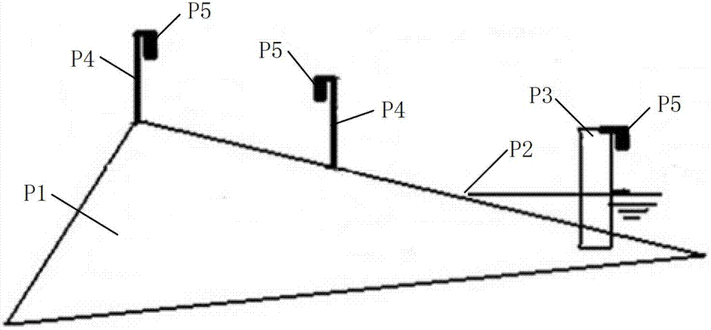
[0007] (1) Due to the uncertainty of the amount of ore drawn each time in the tailings pond, the deposition process of the sedimentary beach surface is irregular, so the sedimentary beach is not a flat slope, but an undulating surface; at the same time, with the tailings With the continuous deposition of tailings in the slurry, the slope of the sedimentary beach also presents an ever-changing curve; in the existing slope calculation method, only two detection points are used to determine the length of the dry beach. Therefore, there is a large deviation in the dry beach length of the tailings pond measured by the existing slope calculation method, which cannot truly and accurately reflect the actual safety situation of the tailings pond
[0008] (2) Due to the vast area of ​​the dry beach of the tailings reservoir, many monitoring rods need to be set up on the surface of the dry beach according to the existing slope calculation method, and most of the monitoring rods are far apart, so the absolute height of the level gauge on the top of the monitoring rod is usually It is necessary to select a stable highest point (for example: the top of a mountain) as the reference point for surveying and mapping, and then use coordinate transfer to determine it; but usually the accuracy of the reference point for surveying and mapping is low, which makes the coordinate systems of the various measurement systems in the tailings pond inconsistent. Therefore, there will be a certain measurement error in the measured absolute height of the level meter, which will cause a large error in the measurement of the length of the dry beach of the tailings pond, and cannot accurately reflect the actual safety status of the tailings pond
[0009] (3) The sedimentary shoal formed by the tailings is in a soft state. After the monitoring rod is buried in it, it will sink or tilt due to its own weight and the weight of the level gauge, which will cause serious deviations in the measurement results; at the same time, with the sedimentary shoal The tailings gradually increase, and the monitoring poles will gradually be buried and cannot be recovered; therefore, the existing slope calculation method needs to re-bury expensive monitoring poles in stages
[0010] (4) Because most of the tailings contain corrosive substances, in the existing slope calculation method, if the power supply cable and communication cable of the level meter are buried in the ground, they will be strongly corroded and the service life will be extremely short ; If the power supply cable and communication cable are installed in the aerial laying method, there will be serious problems such as lightning strikes, tilting of the pole, and the pole being buried when the dry beach is lifted.

Method used


Image

  • Method and system of measuring length of dry beach of tailing pond
  • Method and system of measuring length of dry beach of tailing pond
  • Method and system of measuring length of dry beach of tailing pond

Examples


Embodiment 1

[0121] Such as Figure 2 to Figure 6 As shown, the measurement system of the dry beach length of the tailings reservoir provided by the embodiment of the present invention is applied to such as figure 2 In the tailings pond shown, the dry beach length of the tailings pond is monitored in real time according to the method for measuring the dry beach length of the tailings pond provided by the embodiment of the present invention.

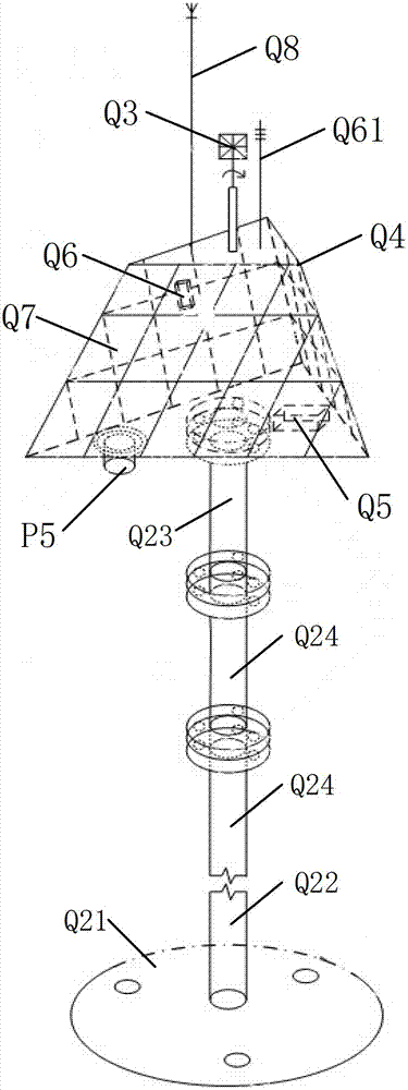
[0122] The specific structure of the measurement system for the dry beach length of the tailings reservoir can include: a data processing device, an intelligent total station and a dry beach monitoring device; image 3 As shown, the specific structure of the dry beach monitoring device may include: connecting rod Q2, target Q3, level meter P5, triangular platform box body Q4, battery Q5, lightning rod Q8 and wireless data transmission module Q6; triangular platform box body The lower part of Q4 is fixed on the top of the connecting rod Q2, the level...


PUM


Abstract

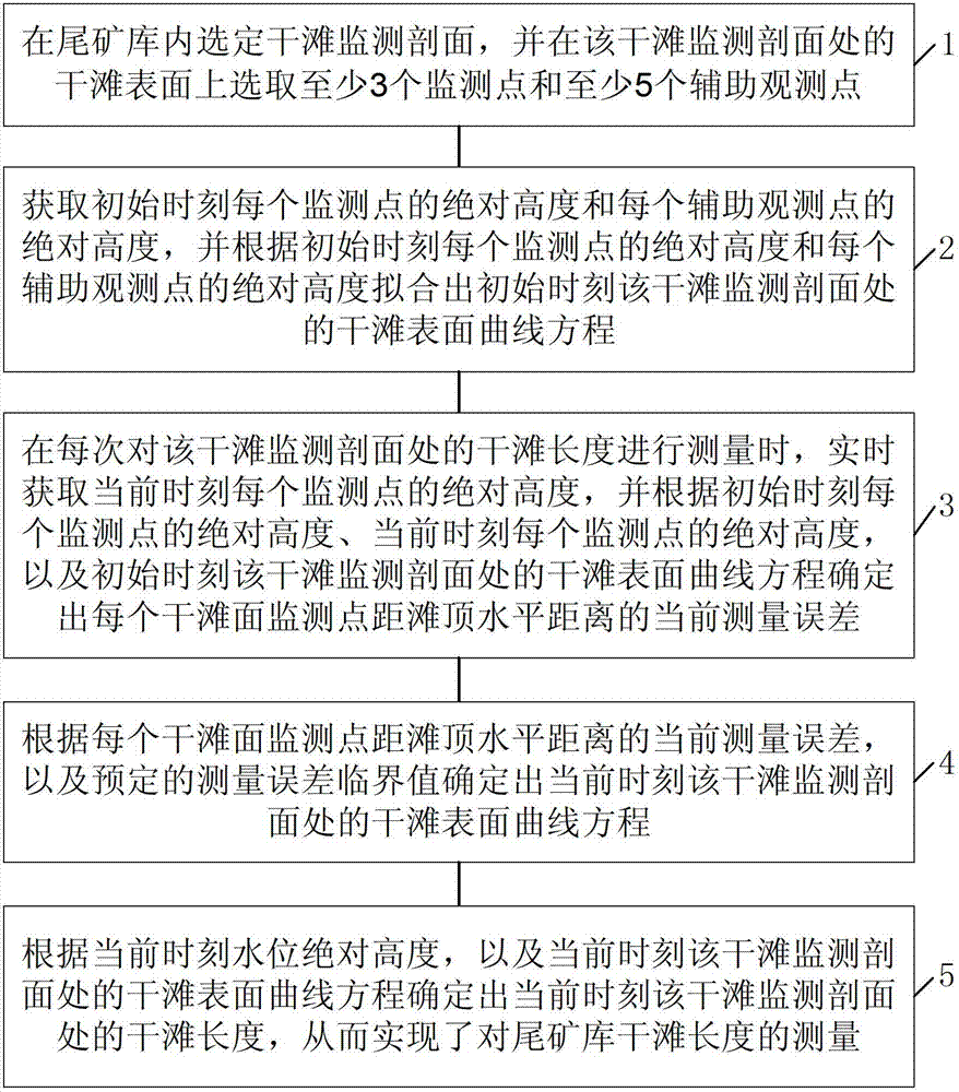
The invention discloses a method and a system of measuring a length of a dry beach of a tailing pond. The method comprises selecting monitoring profiles of the dry beach in the tailing pond, selecting at least three monitoring points and at least five auxiliary observation points on surface of the dry beach, obtaining absolute heights of each monitoring point and auxiliary observation point at an initial time, furthermore fitting a curve equation of the dry beach surface at the monitoring profiles of the dry beach at the initial time, during measurement, obtaining an absolute height of each monitoring point at current time in real time, combining the absolute height of each monitoring point and the curve equation of the dry beach surface at the initial time, determining current measurement errors of horizontal distances of each monitoring point of the dry beach surface from the beach top, furthermore determining a curve equation of the dry beach surface at the monitoring profiles of the dry beach at current time in accordance with a predetermined measurement error threshold, and determining the length of the dry beach at the monitoring profiles of the dry beach at current time in accordance with the absolute height of the water level and the curve equation of dry beach surface in the current moment, thereby realizing measurement of the length of the dry beach of the tailing pond. The method can timely, accurately and reliably measure the length of the dry beach, and thus accurately reflect actual security situations of the tailing pond and effectively reduce risks of occurring security incidents in the tailing pond.

Description

technical field [0001] The invention relates to the technical field of tailings pond safety, in particular to a method and system for measuring the dry beach length of a tailings pond. Background technique [0002] Tailings pond refers to a place formed by damming and intercepting valley mouths or enclosures to store tailings discharged after ore dressing or waste residues discharged from other industrial production (such as: power generation waste residues); it is a place with high potential energy There is a risk of dam failure as a source of man-made debris flow hazards, so safety monitoring of tailings ponds is imperative. [0003] The tailings pond mainly passes through the tailings dam (the tailings dam includes two parts: the initial dam and the accumulation dam; the initial dam refers to the dam used to support the tailings stockpiling body in the infrastructure; the accumulation dam refers to the A dam built with tailings filling above the top) to intercept the sol...

Claims


Application Information

Patent Timeline
IPC IPC(8): G01C3/28G01C5/00
Inventor 杨小聪张达袁子清张晓朴余乐文陆得盛
Owner BEIJING GENERAL RES INST OF MINING & METALLURGY
Learn More