
An underground personnel positioning system

A technology for personnel positioning and personnel, which is applied to services based on location information, advanced technology, mining equipment, etc. It can solve the problems of limited distribution density of positioning accuracy readers, inability to achieve precise positioning, and large positioning errors.

Active Publication Date: 2015-11-25
CHINA UNIV OF MINING & TECH (BEIJING)
View PDF4 Cites 4 Cited by
  • Summary
  • Abstract
  • Description
  • Claims
  • Application Information

AI Technical Summary

Problems solved by technology

[0004] 1. The positioning accuracy is limited by the distribution density of the readers, and can only achieve regional positioning, and cannot achieve accurate positioning with an error of a few meters;
[0005] 2. Limited by the reading and writing speed of RFID, it cannot handle the situation that many people pass through the card reading system at the same time, and it is easy to miss reading
However, the transmission loss model of wireless signals is greatly affected by the environment, so the general RSSI positioning system often has to rely on increasing the density of anchor nodes and using a global optimization algorithm to control the positioning error in one direction, but the underground environment is mostly a linear environment composed of tunnels. Field strength data in other directions on the plane cannot be obtained, so when there are other factors affecting wireless signal transmission such as large metal obstructions in the tunnel, the positioning error is large, so a field strength data that does not depend on other directions is needed A positioning system that can accurately locate underground

Method used


Image

  • An underground personnel positioning system
  • An underground personnel positioning system
  • An underground personnel positioning system

Examples


Embodiment Construction

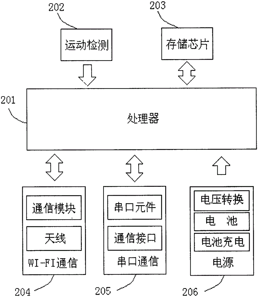
[0035] Such as figure 1 In the illustrated embodiment, the components of the positioning system include:

[0036] The underground personnel positioning system includes a positioning server (1), a wired communication subsystem, a wireless communication base station (2) and a positioning device (3). The wired communication subsystem is the backbone network of the entire positioning system, and the wired communication subsystem uses optical fiber as the main transmission medium. The wired communication subsystem also includes network management equipment such as an optical splitter and a wireless switch (5). The wireless communication base station is installed at a certain distance underground, and the wireless communication base station is connected to the server on the well through optical fiber. The main function of the wireless communication base station is WI-FI wireless access. The wireless communication base station includes explosion-proof boxes, power supplies, backup ...


PUM


Abstract

The invention discloses an underground personnel positioning system comprising a positioning server, a monitoring terminal, a wired communication subsystem, wireless communication base stations and a positioning device, wherein the wired communication subsystem mainly comprises an optical fiber, an optical splitter and a wireless switch; the wireless communication base station mainly comprises an anti-explosion box, a power source, a spare battery, wireless access equipment, an antenna and the like; the wireless communication base stations are mounted inside an underground channel at intervals with a certain distance; the wireless communication base stations are connected with the wireless switch and the positioning server above a well through optical fibers; the positioning device and the wireless communication base stations are communicated in a wireless manner; and the system realizes personnel accurate positioning based on a combined field intensity distance measurement and step counting distance measurement manner through a positioning device carried by the underground personnel. The positioning system provided by the invention has the advantages of high positioning precision, low cost and simple structure of system equipment, is convenient for dispatching management of management personnel in safe production, and can provide more accurate personnel position information for rescue personnel, so as to improve the rescue efficiency and rescue rate of trapped people; and the underground personnel positioning system is a comprehensive system integrating underground personnel attendance, dispatching management, tracking and positioning, after-calamity rescue and the like.

Description

technical field [0001] The invention relates to an underground personnel positioning system, and the system relates to the fields of radio communication, ranging and positioning technology and the like. Background technique [0002] Downhole personnel positioning is an important measure for safe production. Over the years people have adopted various methods to detect the position of underground personnel. Commonly used positioning methods are: receiving signal strength indication (ReceivedSignalStrengthIndication, RSSI), measuring angle of arrival (AngleOfArrival, AOA), measuring time of arrival (TimeOfArrival, TOA), measuring time difference of arrival (TimeDifferenceOfArrival, TDOA) and radio frequency identification technology (RFID, RadioFrequencyIdentification ) and other methods. [0003] At present, the actual use is mainly based on radio frequency identification technology (RFID). RFID uses radio frequency to carry out non-contact two-way communication to achieve t...

Claims


Application Information

Patent Timeline
Patent Type & Authority Patents(China)
IPC IPC(8): H04W4/02H04W64/00E21F17/18
CPCY02D30/70
Inventor 孙继平刘毅
Owner CHINA UNIV OF MINING & TECH (BEIJING)
Learn More