
Emergency management system

a management system and emergency technology, applied in the field of emergency management system, can solve the problems of difficult to determine the best way to allocate outside resources, insufficient local resources such as police, fire protection and heath care, and affecting a large number of people, so as to minimize further injury or damage, improve communication between decision makers, and track and manage progress.

Inactive Publication Date: 2005-03-15
NORTH FLORIDA UNIV OF
View PDF14 Cites 128 Cited by
  • Summary
  • Abstract
  • Description
  • Claims
  • Application Information

AI Technical Summary

Benefits of technology

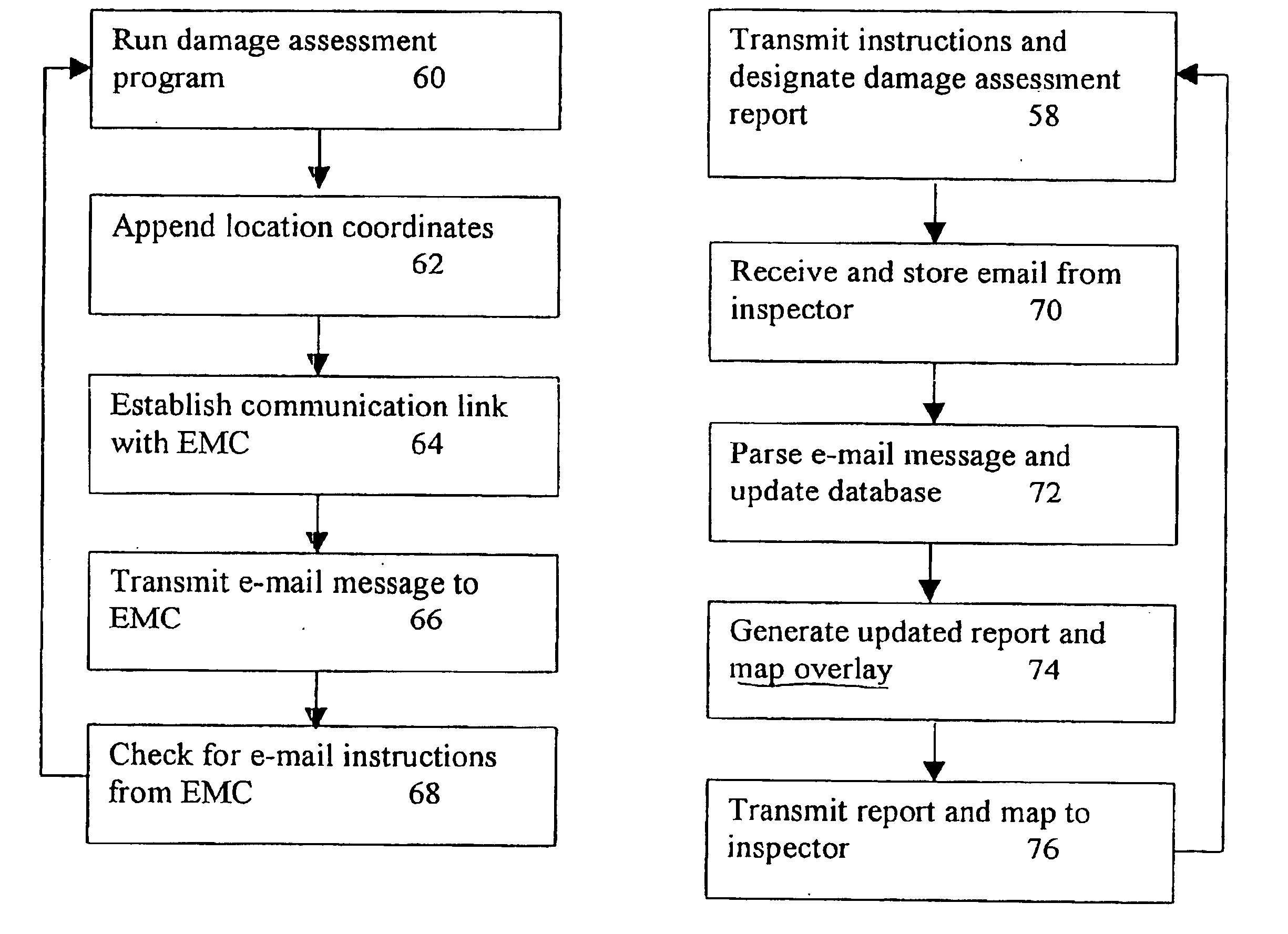
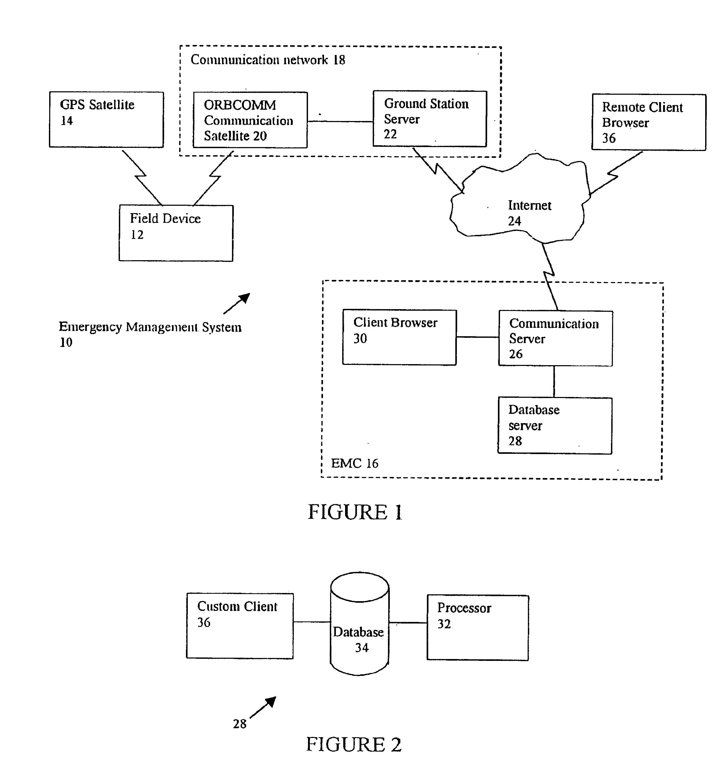
The present invention provides real time field assessment data to emergency management centers (EMCs) through distributed communications networks. Significantly, the present invention collects field assessment information and generates intuitive graphical displays and summary reports to enable the prompt and accurate field assessment at the EMC. Communications directing the deployment of resources are then transmitted to a plurality of EMC and response personnel. It will be apparent to one skilled in the art that after a disaster an EMC needs good and accurate information in the hours immediately following a disaster to allocate scarce resources and to assess the scope of the damage. Accordingly, other statistical tools are provided so that an analysis of the scope and magnitude of the disaster may be timely determined. Thus, the present invention provides timely and accurate information to the EMCs and enables the prompt and efficient allocation of scarce resources.
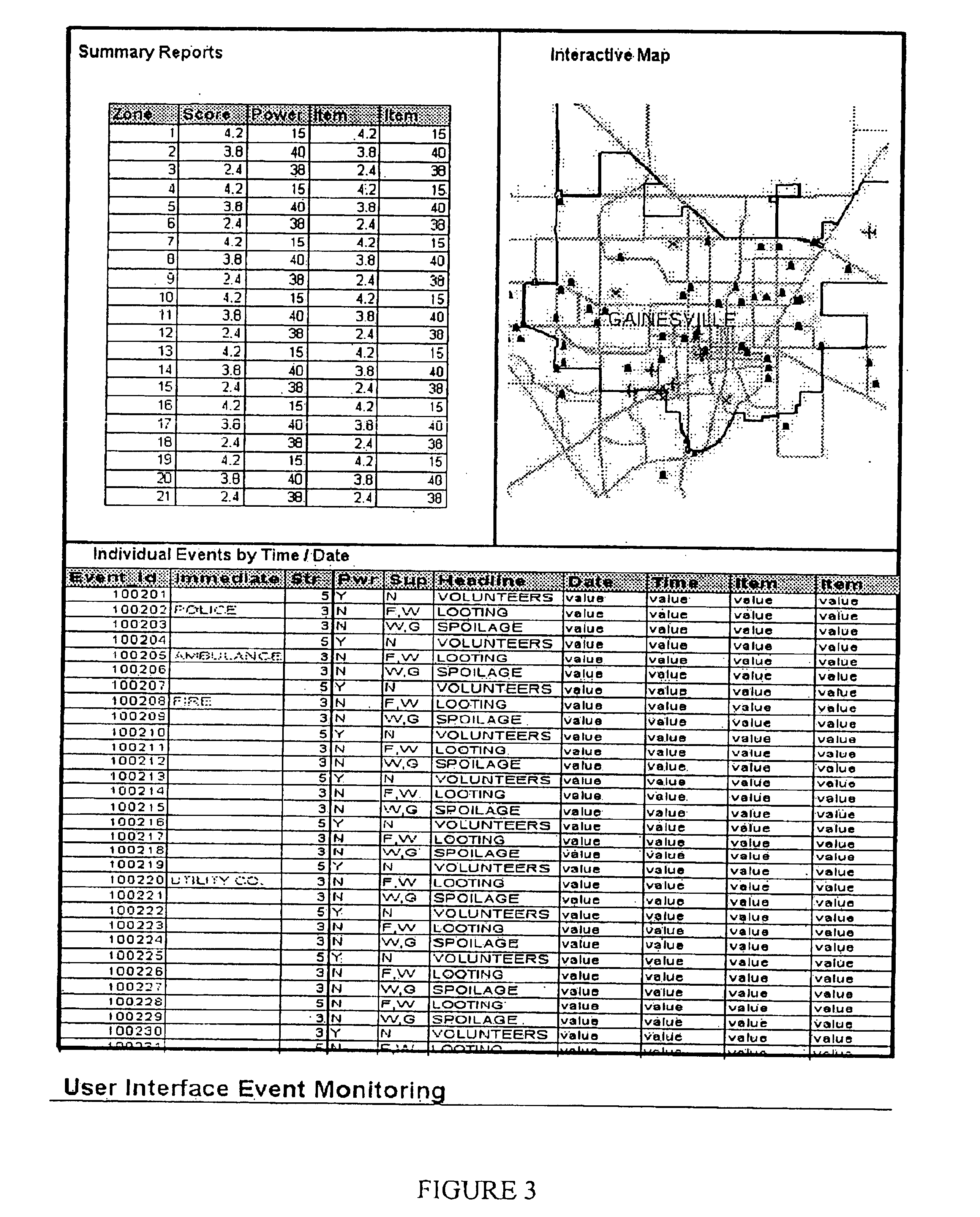
At the EMC, the baseline data and the maps are combined with real-time field data to generate graphical indicators of the damage in a geographical and / or summary report format and the type of emergency resources required in each of the damaged geographical areas. As outside resources arrive, the EMC is able to add the type of resource to the baseline data and generate a timely deployment to selected areas. The information from the EMC showing the extent of the damage and the available resources may be transmitted to other EMCs and field personnel so that the extent of the disaster is known to all and planning for how to respond to unmet needs is enhanced.
Based on aggregation and analysis of information received at the EMC, inspectors can be repositioned to rapidly generate a complete picture of the geographical area affected by the disaster. Because the present system and method guarantees two-way, real-time data flow, managers at the EMC will be able to track and manage the progress of the inspectors more efficiently than has been possible before. The real time information will also be available though the Internet to authorized officials or to the public as appropriate so that reports and maps will identify the areas most affected by the disaster as well as the type of resources required to minimize further injury or damage.
Advantageously, instantaneous and precise delivery of real-time field assessments from the disaster area by trained inspectors deployed throughout the affected zone is provided in a timely manner. Updated summary reports and maps of the information available are continuously available on the Internet for use by state and local emergency managers authorized to view the real time geographical database. Greater access to information on the actual damage to the affected area improves communications between decision makers and provide better inter-governmental coordination at all levels.

Problems solved by technology

When such disasters occur, the scope of the damage is generally geographically dispersed and may affect vast numbers of people and extensive damage to infrastructure.
In the time period immediately following the disaster, local resources such as police, fire protection and heath care are often inadequate to respond to all of the problems related to the disaster.
Often, outside resources are required to supplement local resources and, since the disaster may be geographically widespread, it is often difficult to determine how best to allocate these outside resources.
When the disaster is widespread, such as occurs after a hurricane or earthquake, several EMCs are established throughout the region so coordinating the aid requests and efficiently allocating resources becomes a major and complicated task.
Often, however any information that arrives at the EMC is anecdotal, resulting in improper allocation of scarce resources.
Indeed, after a major disaster a period of days may pass before a clear picture of the extent and level of damage begins to form at the EMC.
During the time period immediately following the disaster, individuals may clog the telephone network and harass officials at the EMC and elsewhere for information relating to their personal concerns.
Unfortunately, the EMC that often sends in the first resource requests is the area least affected by disaster while EMCs located in geographical areas with heavy damage are typically overwhelmed and slow to assess the damage, as the emergency response personnel are occupied responding to immediate lifesaving tasks.
Many times EMCs in heavily damaged areas are simply unable to determine what resources are required.
Often the damage to the infrastructure, such as by way of example, highways, power transmission grids, water supply, condition of medical facilities, public buildings, etc., is so heavily damaged that it is difficult to even establish communication between EMCs to request assistance.
Without accurate and timely information, there is a high risk of improperly allocating scarce resources.
During this period there may be little accurate information available to the EMC as to the extent of the damage, or the exact resources that are required.
Because of this information void at the central EMC during the period immediately following the disaster, it is difficult to provide adequate resources in a timely manner.
Unfortunately, this system does not provide for real time assessment of the data at the EMC.
Since decisions at the EMC must be made and resources allocated according to timely assessment of the damage, failure to accurately assess the scope and scale of the damage and allocate resources commensurate with the size of the disaster is possible.
This type of failure to timely analyze the data is a fundamental problem that commonly occurs during and immediately following a disaster.
A significant limitation under which the inspectors must operate arises because they only see a fragment of the disaster area and their immediate impressions may not reflect the situation as it exists in the entire area.

Method used


Image

  • Emergency management system
  • Emergency management system
  • Emergency management system

Examples


Embodiment Construction

The present invention relates to an emergency management system and method. More particularly, the present invention relates to an improved system for an efficient system and method for obtaining and assessing real-time damage and data regarding life-threatening situations from widely dispersed geographical areas. In the following description of the preferred embodiment, reference is made to the accompanying drawings that form a part hereof, and in which is shown by way of illustration a specific embodiment in which the invention may be practiced. It is to be understood that other embodiments may be utilized and that changes may be made without departing from the scope of the present invention. For purposes of illustration, the following description describes the present invention as used with particular field devices in conjunction with web-server computers and web-browser computers coupled to the Internet. However, it is contemplated that the present invention can also be used as ...


PUM


Abstract

A system for automating the gathering of field information that describes the condition of specific geographical locations at specific times via a field information recording device having a GPS receiver for the recording and assignment of the space-time coordinates as information is gathered. The information and space-time coordinates are transmitted to a management center for processing over a communication network. Upon receipt, the field information is integrated into a geographic database such that the information generates a template showing the current state or condition of the identified geographical location on an automated basis. The template and the associated geographical portion of the geographical database are distributed to users via the Internet, intranet or other communication means.

Description

BACKGROUND OF THE INVENTIONIn emergency management, as in other time sensitive activities, timely and accurate information is vital for use in allocating resources as well as achieving other emergency management priorities such as field assessment and analysis. Clearly, in the hours immediately following a disaster there is an urgent need for accurate information to manage the relief effort. As used herein, a disaster includes natural disasters such as hurricanes, fires, earthquakes or famine or man-made disasters such as war or terrorism. When such disasters occur, the scope of the damage is generally geographically dispersed and may affect vast numbers of people and extensive damage to infrastructure. In the time period immediately following the disaster, local resources such as police, fire protection and heath care are often inadequate to respond to all of the problems related to the disaster. Often, outside resources are required to supplement local resources and, since the dis...

Claims


Application Information

Patent Timeline
IPC IPC(8): A62B37/00A62B99/00
CPCA62B99/00
Inventor ALEXANDER, JOHN FRANKLINMERCKEL, GERALDLAMBERT, J. DAVID
Owner NORTH FLORIDA UNIV OF
Learn More