
Risk Management for Cable Protection Via Dynamic Buffering

a risk management and cable protection technology, applied in the direction of instruments, pulse techniques, navigation instruments, etc., can solve the problems of buried asset line damage risk and operating costs, inaccuracy in where the dig actually takes place, and hundreds of sources of error or inaccuracy in this process, so as to minimize the cost risk of an asset line carrying, minimize the risk of asset line damage and operating costs, the effect of minimizing the cos

Inactive Publication Date: 2010-06-24
AT&T INTPROP I L P
View PDF14 Cites 69 Cited by
  • Summary
  • Abstract
  • Description
  • Claims
  • Application Information

AI Technical Summary

Benefits of technology

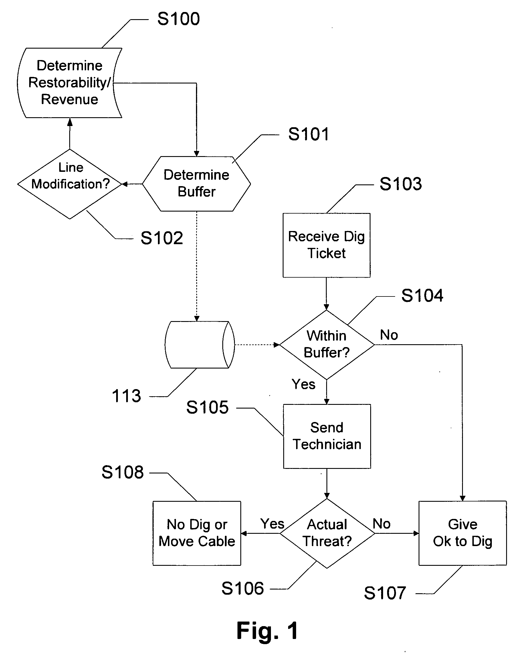
[0012]The present invention optimizes a minimum cost function associated with buried asset lines by using a GIS application to generate a “dynamic buffer” around each asset line based on a risk management algorithm. A risk management algorithm, by which a GIS application can generate a “dynamic buffer”, is employed to minimize asset line damage risk and operating costs by balancing potential costs from damage against the fixed labor costs of manually screened and located tickets. Embodiments of the invention utilize the geography of the situation as well as factors for the asset itself.
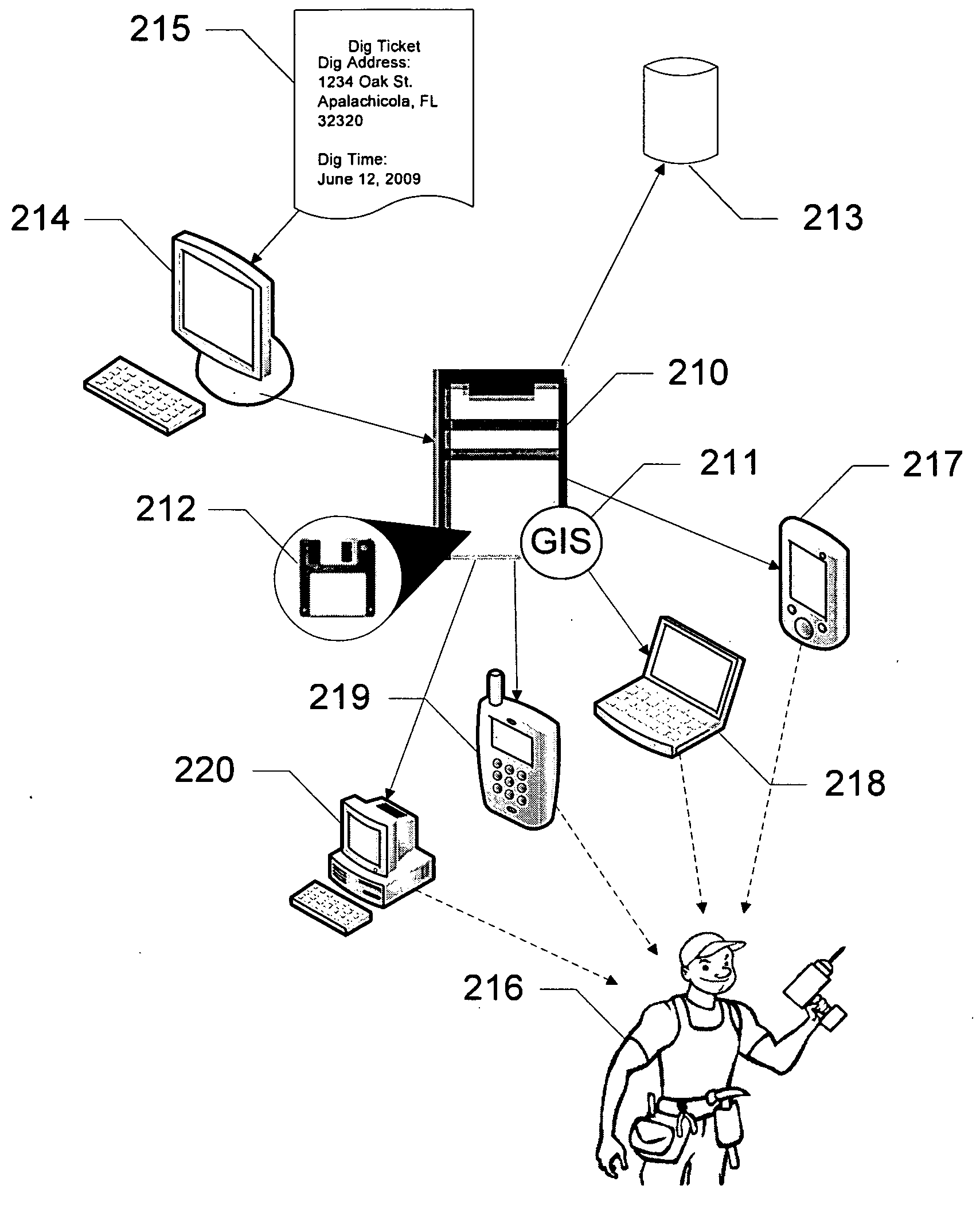
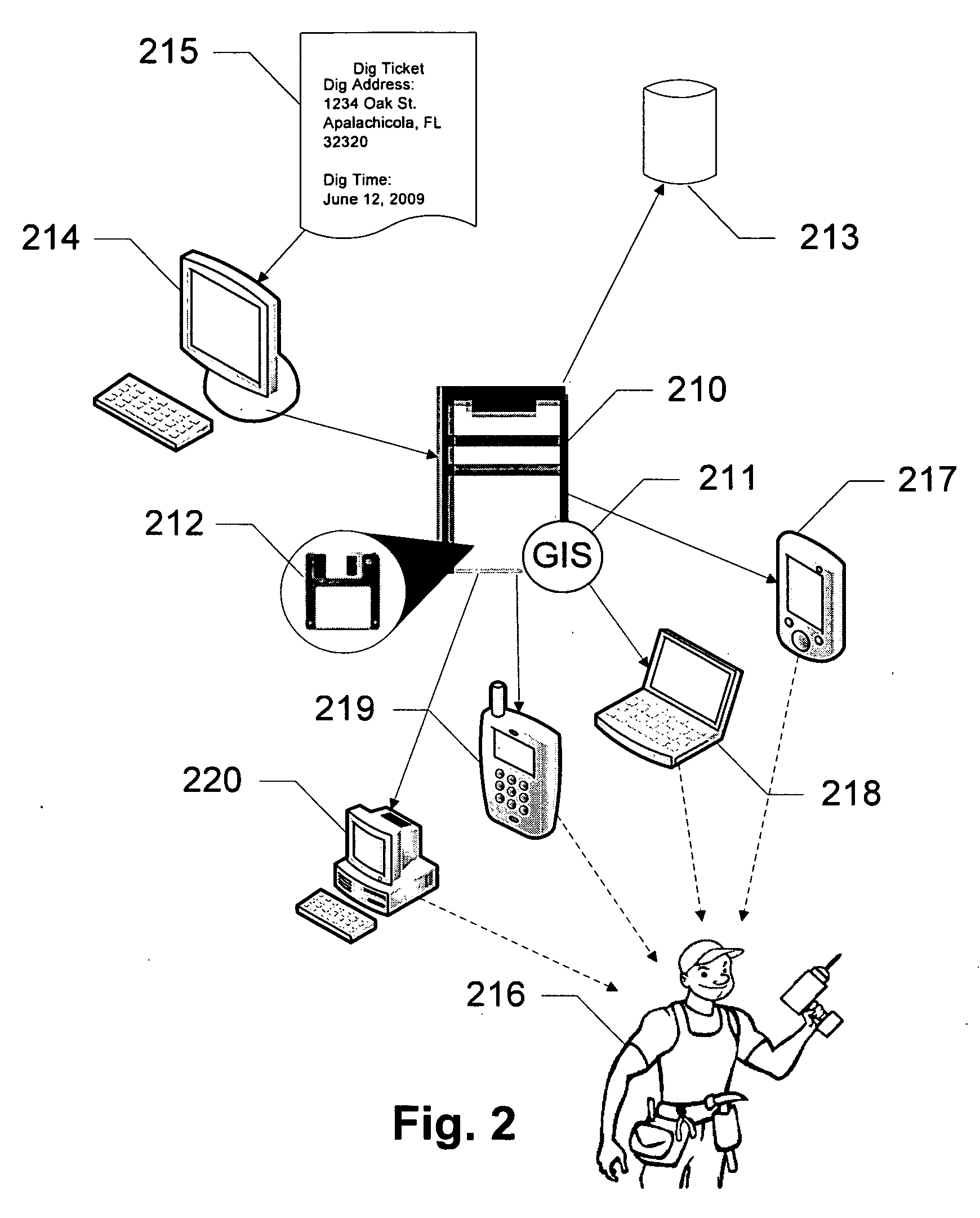
[0013]In one exemplary embodiment, the present invention is a method of minimizing the cost risk of an asset line carrying a utility, comprising assessing a first factor identifying an ability to automatically re-route the utility in the event of a loss of the asset line, assessing a second factor measuring the total value of the utility carried by the asset line, inputting the first factor and the second factor into a risk management algorithm, solving the risk management algorithm for a dynamic buffer width, and assigning the dynamic buffer width to the asset line. A dig location is evaluated by its position with respect to the dynamic buffer width.
[0014]In another exemplary embodiment, the present invention is a system for minimizing the cost risk of a buried asset line carrying a utility, comprising a server, a GIS application on the server, a risk management logic on the server, and a database having a plurality of restorability factors and a plurality of revenue factors in communication with the server. The server responds to a dig location query with an evaluation of a dig location with respect to a dynamic buffer width calculated using the risk management logic.
[0015]In yet another exemplary embodiment, the present invention is a software program, stored on a computer readable medium, for minimizing the cost risk of an asset line carrying a utility, comprising a first code segment for assessing a first factor identifying an ability of the network to automatically re-route communication in the event of a loss of the asset line, a second code segment for assessing a second factor measuring the total value of utility carried by the asset line, a third code segment for inputting the first factor and the second factor into a risk management algorithm, a fourth code segment for solving the risk management algorithm for a dynamic buffer width, and a fifth code segment for assigning the dynamic buffer width to the asset line. A dig location is evaluated by its position with respect to the dynamic buffer width.

Problems solved by technology

The primary cause of damage is construction activities, unrelated to the asset line's excavation, for new building construction, boring, maintenance, installation activities by contractors for other utilities, etc.
This system results in a national company, ONE CALL, receiving several million “dig tickets” per year, each indicating a potentially damaging dig activity which may be near an asset line.
However, there are literally hundreds of sources of error or inaccuracy in this process.
There may be some inaccuracy concerning the asset line's location as well as a lot of inaccuracy in where the dig actually is.
Unfortunately, this is an inherently unreliable process.
Street address data can be missing or imprecise, cable assets may be located slightly incorrectly within the GIS application, or the contractor or ONE CALL operator may have placed incorrect data on the ticket itself.
Even in the best case, there is inherent error as the closest postal “street address” to a dig activity may be meters (or in a rural area, miles) from the actual excavation location.
This unreliability results in risk of cable damage.
A ticket may be improperly judged as “not involved” (i.e., not endangering cable assets).
The contractor is thus given an “all clear” notice from the cable owner, begins to excavate, and cuts a cable, causing damage and revenue losses potentially in the millions of dollars.
This reduces risk, but increases the volume of tickets which must be manually inspected by field personnel.
As each ticket (even if uninvolved) has a labor cost associated with it, this results in a standard tradeoff scenario.
However, with a larger buffer more false positives occur.
Increasing the buffer size increases the number of false positives, but decreased the likelihood of a false negative.
A more valuable asset line is more costly when it is damaged.
For instance, a fiber optic line may carry a small amount of data when it is first installed, making it of relatively little value.

Method used


Image

  • Risk Management for Cable Protection Via Dynamic Buffering
  • Risk Management for Cable Protection Via Dynamic Buffering
  • Risk Management for Cable Protection Via Dynamic Buffering

Examples


Embodiment Construction

[0022]The present invention optimizes a minimum cost function associated with buried asset lines by using a GIS application to generate a “dynamic buffer” around each asset line based on a risk management algorithm. A risk management algorithm, by which a GIS application can generate a “dynamic buffer”, is employed to minimize asset line damage risk and operating costs by balancing potential costs from damage against the fixed labor costs of manually screened and located tickets. Embodiments of the invention utilize the geography of the situation as well as factors for the asset itself.

[0023]“Asset line,” as used herein and throughout this disclosure, refers to a buried medium used in connection with a service. Examples of an asset line include an electrical line, water pipe, gas pipe, telephone cable, coaxial cable, fiber optic line, etc.

[0024]The risk management algorithm depends upon a GIS “auto-screening” application having access to certain cable logical parameters. The first o...


PUM


Abstract

Devices, systems and methods are disclosed which relate to optimizing a minimum cost function associated with buried asset lines by using a GIS application to generate a “dynamic buffer” around each asset line based on a risk management algorithm. A risk management algorithm, by which a GIS application can generate a “dynamic buffer”, is employed to minimize asset line damage risk and operating costs by balancing potential costs from damage against the fixed labor costs of manually screened and located tickets. Embodiments of the invention utilize the geography of the situation as well as factors for the asset itself.

Description

BACKGROUND OF THE INVENTION[0001]1. Field of the Invention[0002]The present invention relates to optimizing a minimum cost function associated with buried asset lines. More specifically, the present invention relates to optimizing a minimum cost function associated with buried asset lines by using a GIS application to generate a “dynamic buffer” around each asset line.[0003]2. Background of the Invention[0004]The protection of buried asset lines, such as fiber optic cables, telephone lines, power lines, water pipes, gas pipes, etc., from damage is of paramount concern to utility companies. The primary cause of damage is construction activities, unrelated to the asset line's excavation, for new building construction, boring, maintenance, installation activities by contractors for other utilities, etc. The National “Call Before You Dig” program is the first step in the protection process. This system results in a national company, ONE CALL, receiving several million “dig tickets” per ...

Claims


Application Information

Patent Timeline
IPC IPC(8): G06Q10/00G01C21/00G06N5/02G06Q50/00
CPCG06Q10/06G06Q40/08G06Q10/0635
Inventor ASHER, MICHAEL
Owner AT&T INTPROP I L P
Learn More