
Precise orbit determination system and method using GPS data and galileo data

a global positioning system and orbit determination technology, applied in satellite radio beaconing, measurement devices, instruments, etc., can solve the problems of user inability to provide continuous positioning service and signal reliability drop, so as to improve convenience and prevent signal disconnection phenomenon

Inactive Publication Date: 2010-04-15
ELECTRONICS & TELECOMM RES INST
View PDF7 Cites 20 Cited by
  • Summary
  • Abstract
  • Description
  • Claims
  • Application Information

AI Technical Summary

Benefits of technology

[0010]According to the present invention, both UPS and Galileo data is received in a LEO satellite, and a data format containing both types of data is defined, so that an orbit determination system can be established and used with improved convenience.
[0012]Furthermore, since the Galileo data in addition to the GPS data is used, navigation satellites at a high altitude are available at any time. Accordingly, a service system that can provide the position of a user without a signal disconnection phenomenon even when the user passes between high-rise buildings can be established.

Problems solved by technology

Even though the precision in orbit determination using GPS data is currently highly accurate because of being free from selective availability (SA), it is uncertain when the SA will arise again and then the reliability of signals will drop.
Furthermore, a signal disconnection phenomenon frequently occurs while a moving object goes through a tunnel, under an overpass, or between high-rise buildings and therefore a user cannot be provided with continuous positioning service.

Method used


Image

  • Precise orbit determination system and method using GPS data and galileo data
  • Precise orbit determination system and method using GPS data and galileo data
  • Precise orbit determination system and method using GPS data and galileo data

Examples


Embodiment Construction

[0026]Hereinafter, the present invention will be described in detail by explaining exemplary embodiments of the invention with reference to the attached drawings. Like reference numerals in the drawings denote like elements. In the following description, detailed descriptions on related disclosed functions or structures are not provided if they could make the subject matter of the present invention unclear.

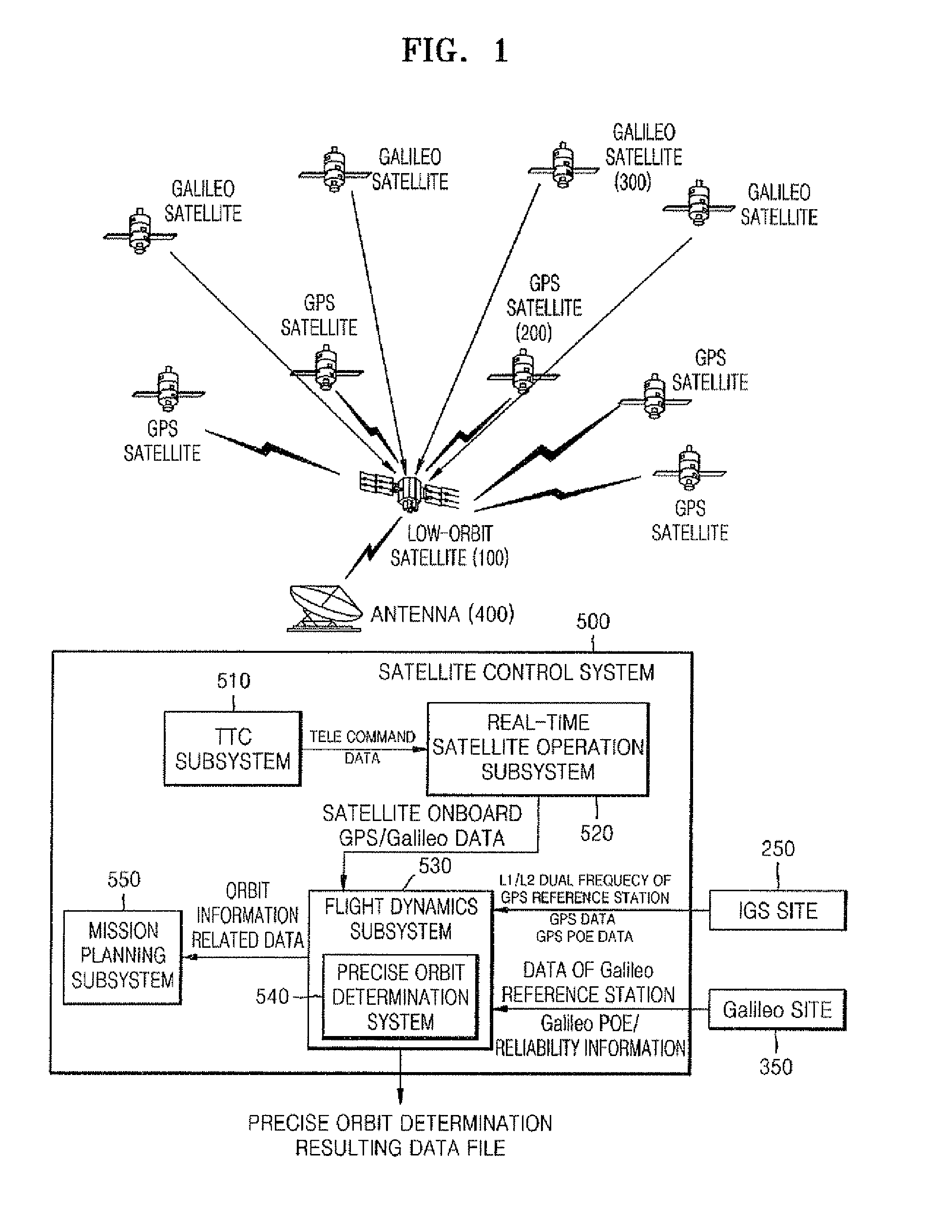
[0027]FIG. 1 is a diagram showing a structure of a satellite control system involved in precise orbit determination according to the present invention.

[0028]Referring to FIG. 1, a LEO satellite 100 receives global positioning system (GPS) data from a GPS satellite 200 and Galileo data from a Galileo satellite 300. The GPS and Galileo data, which are raw and onboard data, received by the LEO satellite 100, and the status information and other items of information of other satellites are transmitted to a TTC (Telemetry, Tracking and Command) subsystem 510 of the satellite control sy...


PUM


Abstract

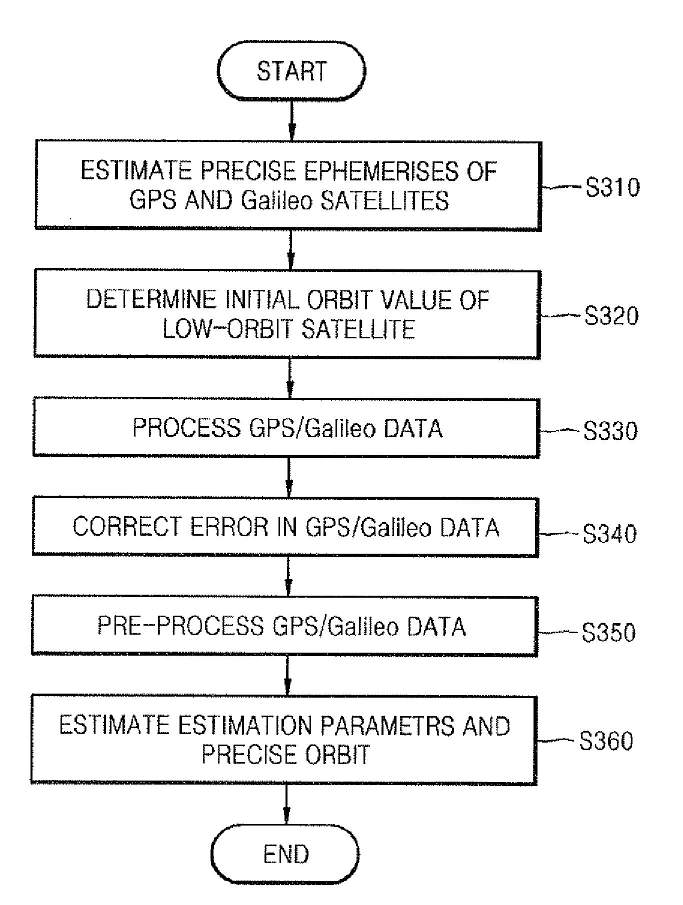
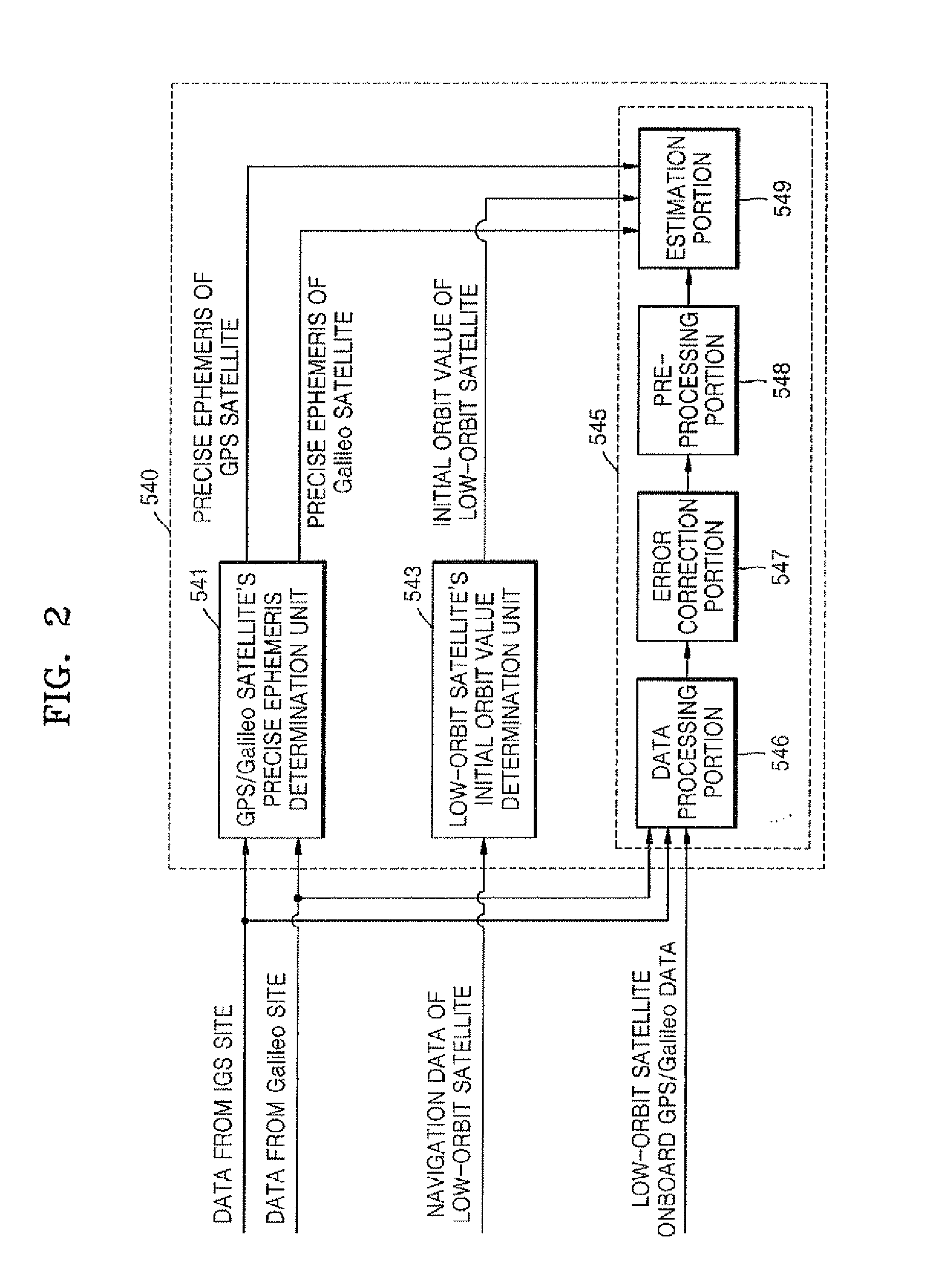
Provided are a method and system for determining a precise orbit of a LEO satellite. The method includes: estimating a precise ephemeris of a global positioning system (GPS) satellite by fitting an orbit perturbation-based GPS dynamics model to observation data of the GPS satellite received from a GPS observatory and estimating a precise ephemeris of a Galileo satellite by fitting an orbit perturbation-based Galileo dynamics model to observation data of the Galileo satellite received from a Galileo observatory; determining an initial orbit value of a LEO satellite by fitting an orbit perturbation-based LEO satellite's basic dynamics model to navigation data received from the LEO satellite; and determining the precise orbit of the LEO satellite by calculating a difference between observation values, which are calculated based on a GPS and Galileo data received from the LEO satellite, the GPS observatory and the Galileo observatory, and calculated values, which are calculated based on an orbit perturbation-based LEO satellite's dynamics model that was calculated using the initial orbit value of the LEO satellite and the precise ephemeris of the GPS and Galileo satellites. Since both the GPS and Galileo data are received and used to determine the precise orbit of a LEO satellite, more precise orbit determination can be achieved.

Description

TECHNICAL FIELD [0001]The present invention relates to a precise orbit determination system and method using global positioning system (GPS) data and Galileo data, and more particularly, to a precise orbit determination system and method that can further improve the precision in orbit determination using both Galileo data and GPS data having high reliability, which are received by a combined receiver for receiving both the Galileo data and the GPS data.BACKGROUND ART[0002]Global positioning system (GPS) is used to accurately measure the position of an object on and over the earth using satellites. The GPS, which was developed by the United States Department of Defense for military purposes, measures the position of an object using at least 24 satellites with such a high precision that there is an error of only 1 centimeter allowed in military use and 5 meters in civilian use. The GPS is now operated with 28 satellites orbiting the globe since the launching of its first GPS satellite...

Claims


Application Information

Patent Timeline
IPC IPC(8): G01S19/41G01S5/14G01S19/09G01S19/14G01S19/33G01S19/39G01S19/42
CPCG01S19/09G01S19/14G01S19/42G01S19/39G01S19/33G01S19/396
Inventor HWANG, YOOLALEE, BYOUNG-SUNKIM, HAE-YEONKIM, JAE-HOON
Owner ELECTRONICS & TELECOMM RES INST
Learn More