Mobile ocean geographic information and marine hydrological environment monitoring method and system thereof

A geographic information system and geographic information technology, applied in the field of mobile marine geographic information monitoring of the marine hydrological environment, can solve problems such as hindering the hydrological cycle and oxygen cycle, fish and bird death, poisoning death, etc.

Inactive Publication Date: 2006-12-27
高圣龙
View PDF0 Cites 11 Cited by
  • Summary
  • Abstract
  • Description
  • Claims
  • Application Information

AI Technical Summary

Problems solved by technology

[0009] 3. Accidental leakage of offshore oil wells
[0010] 4. Leakage from tankers and oil unloading stations under normal conditions
[0012] 6. Oil spill from tanker accident
In addition, crude oil can disable feathers and fish gills, making it possible for fish and birds to die from direct contact with crude oil; ecosystems are disrupted or out of balance
[0016] 2. Nearshore organisms are poisoned and died due to ingestion or contact with oil pollution, including plankton, crustaceans, fish, seabirds, marine mammals, etc., which are all vulnerable organisms
[0017] 3. The smell of oil pollution confuses the sense of smell of marine organisms and creates an obstacle to foraging; while the oil film covering the sea surface will also hinder the hydrological cycle and oxygen cycle, which also causes the imbalance of the ecosystem
[0018] 4. The black oil film and dead marine organisms have caused the deterioration of the landscape; they have also hindered the activities of humans and marine organisms in the ocean
[0019] 5. Heterocyclic compounds in oil pollution will accumulate in the organism and be difficult to release, and cause the amplification of the food chain. The final victim will be human beings

Method used


Image

  • Mobile ocean geographic information and marine hydrological environment monitoring method and system thereof
  • Mobile ocean geographic information and marine hydrological environment monitoring method and system thereof

Examples


Embodiment Construction

[0051] The novelty and other characteristics of the present invention will become clearer with the following detailed description of the accompanying drawings and preferred embodiments.

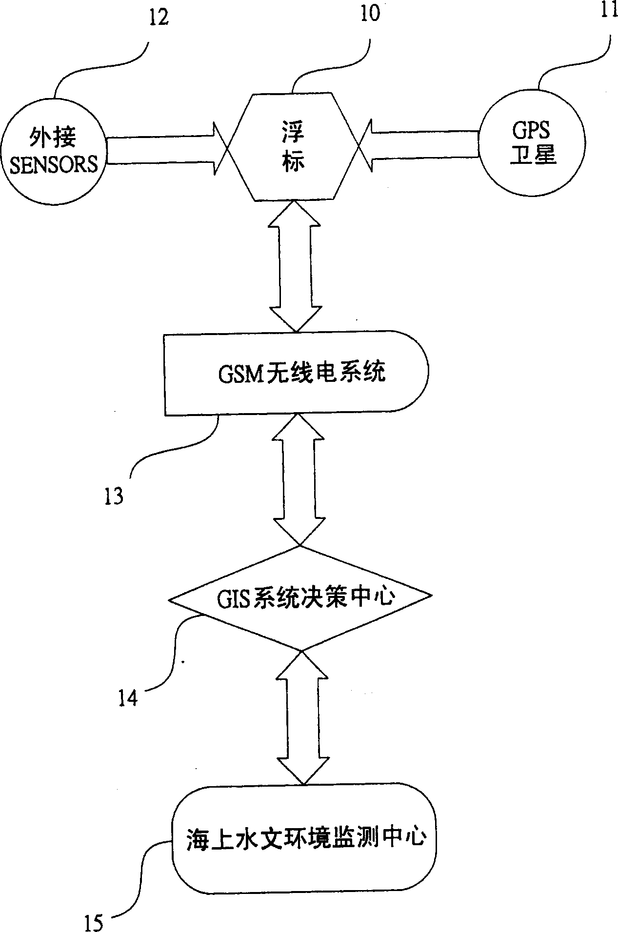
[0052] Please see first figure 1, in the preferred embodiment shown in the figure, the monitoring system of the present invention mainly puts the mobile carrier 10 (such as: buoy, monitoring ship, etc.) into the required specific sea area, and installs global satellites on the carrier 10 The positioning system 11 can determine the position of the vehicle 10; use various digital external detectors 12 installed, such as: water quality, water temperature, flow direction, flow velocity, etc. to detect the target item After the measurement, all the necessary data of the local environment (such as: weather, walrus, water temperature, water quality, GPS information, etc. -------) are integrated through the internal single-chip reduced instruction set (AVR, not shown in this picture) , the data can ...


PUM


Abstract

The invention relates to a movable sea geography information geohydrologic environment detecting method and relative system, especially providing system that combines data communication technique to detect the marine pollution source, wherein the carried GPS will calculate out the position and time of pollution source, and uses variable digit detectors to combine the single-chip technique to feedback the data via wireless transmission system; the obtained data is processed to be environment space detecting information, to be analyzed by MGIS system.

Description

technical field [0001] The present invention relates to a mobile marine geographic information marine hydrological environment monitoring method and its system, especially a vehicle that uses data communication technology to transmit received data to a marine geographic information control and management center through programming language design. A platform-based data monitoring system for the development of pollution sources. Background technique [0002] 70% of the earth is ocean, which is the origin of all life. Of course, there are many resources that can be used. Therefore, the maintenance and sustainable management of the ocean is very important. However, ignorant human beings have been ruthlessly ruining it. The seawater in the area has been polluted, causing serious damage to the local ecological environment and fishery economic value. Faced with the rising awareness of environmental protection in various countries, many countries have invested a lot of energy and ...

Claims


Application Information

Patent Timeline
Patent Type & Authority Applications(China)
IPC IPC(8): G01C13/00G08C17/02G01S1/02G01S19/42
Inventor 高圣龙
Owner 高圣龙
Why Eureka
Try Eureka