
Method and system for dealing emergency status utilizing GPS terminal

A GPS terminal, emergency technology, applied in the direction of road vehicle traffic control system, traffic control system, radio wave measurement system, etc., can solve the problems of easily causing traffic accidents, difficult to change lanes, and fast driving without emergency vehicles.

Inactive Publication Date: 2006-11-29
LG ELECTRONICS (CHINA) R&D CENT CO LTD
View PDF0 Cites 9 Cited by
  • Summary
  • Abstract
  • Description
  • Claims
  • Application Information

AI Technical Summary

Problems solved by technology

[0007] However, at present, in the case of dispatching emergency vehicles, there is no traffic control or road traffic regulations and related facilities for the rapid travel of emergency vehicles. It is only acquiesced that ordinary vehicles in the running will give way by themselves when they find emergency vehicles at close range. Road rules
[0008] At this time, ordinary vehicles in motion need to get out of the lane in order to allow the emergency vehicle to move quickly, but it is difficult to change the lane currently in motion on a road with heavy traffic
In this case, emergency vehicles can only drive slowly, especially on congested roads or crossroads waiting for signal lights, they can only stop and wait for the road to clear, which will delay the dispatching time of emergency vehicles, and the property and life disasters at the fire site will be delayed. the situation is more serious
Moreover, when emergency vehicles ignore traffic signals, it is easy to cause traffic accidents

Method used


Image

  • Method and system for dealing emergency status utilizing GPS terminal
  • Method and system for dealing emergency status utilizing GPS terminal
  • Method and system for dealing emergency status utilizing GPS terminal

Examples


Embodiment Construction

[0031] Beneficial embodiments of the present invention will be described below with reference to the drawings. The same structures in the drawings will be given the same drawing symbols and symbols in other drawings. In addition, in the following description, in order to clarify the basic technical idea of ​​the present invention, a detailed description of known technologies or structures related to the present invention will be omitted.

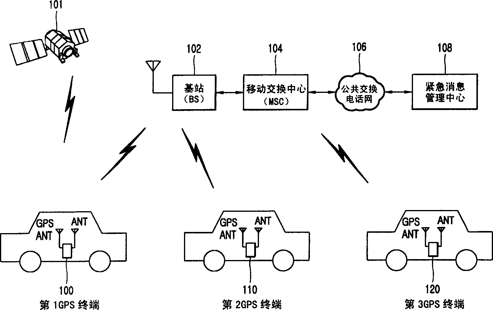
[0032] Refer to the attached figure 1 An emergency response system that allows an emergency vehicle equipped with a GPS terminal to travel quickly in an emergency situation will be described, figure 1 is a structural diagram of the emergency response system in the embodiment of the present invention.

[0033] The emergency response system of the embodiment of the present invention includes: GPS satellite 101; GPS terminals 100, 110, 120; base station (BS: Base Station) 102; mobile switching center (MSC: MobileStation Center) 104; public swi...


PUM


Abstract

This invention relates to the use of GPS terminal system and its replication method of emergency situation, which make emergency vehicles move quickly in emergency situations. So said method includes when the GPS terminals of emergency vehicles transmit emergency information to emergency information management center, after receipt of said emergency information, the center transmit warning information used for hinting the driving emergency vehicles to the GPS terminals of common vehicles, while the GPS terminals of common vehicles who receive said warning information will prompt the user received warning information.

Description

technical field [0001] The present invention relates to an emergency response method and system using a GPS (Global Position System) terminal, in particular, an emergency response method and system using a GPS terminal to enable emergency vehicles to travel rapidly in an emergency. Background technique [0002] Currently, among various wireless Internet services using mobile communication terminals such as mobile phones and Personal Digital Assistants (PDAs), services based on location technology, in particular, have attracted widespread attention due to their greater applicability and convenience. The above-mentioned wireless Internet service based on positioning technology can be applied to requests for rescue, reporting crimes, geographic information systems (GIS: Geographic Information System) that provide information on adjacent areas, and differential mobile communication charges related to locations, traffic information, Vehicle navigation and logistics control, locat...

Claims


Application Information

Patent Timeline
IPC IPC(8): G08G1/00G08G1/0962G01S5/02G01S19/01
CPCG01C21/36G01S19/01G08B3/10G08G1/0965
Inventor 具正模
Owner LG ELECTRONICS (CHINA) R&D CENT CO LTD
Learn More