Layered image data real-time drawing method and system
A technology for real-time rendering of image data, applied in image data processing, structured data retrieval, geographic information databases, etc., can solve problems such as real-time rendering of layered image data, achieve optimized display effects, ensure accuracy, and prevent image data Blurred or jagged effect
- Summary
- Abstract
- Description
- Claims
- Application Information
AI Technical Summary
Problems solved by technology
Method used
Image

Examples
Embodiment 1
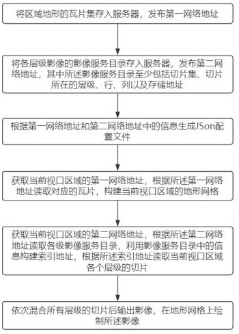
[0070] See Figure 1-Figure 7 , the embodiment of the present invention provides a real-time rendering method of layered image data, the method includes the following steps:
[0071] S1: save the tile set of the regional terrain to the server, and publish the first network address;
[0072] Specifically include:
[0073] S11: Segment the terrain data based on the segmentation method of TMS to obtain terrain slice.terrain data;
[0074] S12: Store the terrain slice.terrain data in the server, and publish the first network address.
[0075] In this embodiment, the global terrain data is downloaded from the geospatial data cloud platform, which also includes terrain data of different levels in each region. Divide the terrain data according to several fixed scales to obtain tiles, each tile is saved as an independent .terrain file, and then transplant all the .terrain files to the HTML folder of the NGINX server, and publish the terrain data URL of the service.
[0076] S2: s...
Embodiment 2
[0164] see Figure 7 , an embodiment of the present invention provides a real-time rendering system for layered image data, the system includes:
[0165] Tile storage module: store the tile set of the regional terrain in the server, and publish the first network address;
[0166] Image slice storage module: store the image service directory of each level of images in the server, and publish the second network address, wherein the image service directory at least includes the slice set, the level where the slice is located, the row, the column and the storage address;
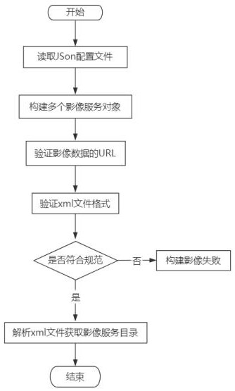
[0167] Configuration file generation module: generate a JSON configuration file according to the information in the first network address and the second network address;
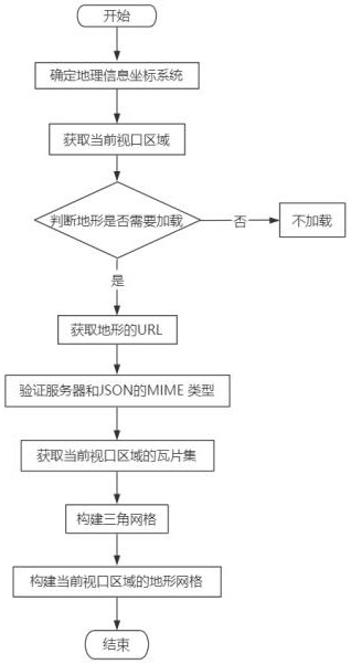
[0168] Terrain grid building module: obtain the first network address of the current viewport area, read the corresponding tile according to the first network address, and construct the terrain grid of the current viewport area;
[0169] Sli...
Embodiment 3
[0172] Corresponding to the above method embodiments, the embodiments of the present disclosure further provide a real-time rendering device for layered image data. The drawing methods can refer to each other correspondingly.
[0173] The electronic device may include: a processor, and a memory. The electronic device may also include one or more of multimedia components, input / output (I / O) interfaces, and communication components.
[0174]Wherein, the processor is used to control the overall operation of the electronic device, so as to complete all or part of the steps in the above-mentioned OD passenger flow prediction method. Memory is used to store various types of data to support operation on the electronic device, such data may include, for example, instructions for any application or method to operate on the electronic device, as well as application-related data such as contacts Data, messages sent and received, pictures, audio, video, and more. The memory can be impl...
PUM
 Abstract
Description
Claims
Application Information
 - R&D
- Intellectual Property
- Life Sciences
- Materials
- Tech Scout
- Unparalleled Data Quality
- Higher Quality Content
- 60% Fewer Hallucinations
Browse by: Latest US Patents, China's latest patents, Technical Efficacy Thesaurus, Application Domain, Technology Topic, Popular Technical Reports.
© 2025 PatSnap. All rights reserved.Legal|Privacy policy|Modern Slavery Act Transparency Statement|Sitemap|About US| Contact US: help@patsnap.com