
Adjustable engineering surveying and mapping device and use method thereof

A surveying and mapping device and an adjustable technology, applied in the directions of surveying devices, surveying and navigation, surveying instruments, etc., can solve the problems of inconvenient carrying, inability to adjust, and insufficient adjustment accuracy.

Inactive Publication Date: 2022-07-15
褚会鹃
View PDF1 Cites 2 Cited by
  • Summary
  • Abstract
  • Description
  • Claims
  • Application Information

AI Technical Summary

Problems solved by technology

[0003] The Chinese invention patent with the publication number CN113915493A discloses a surveying and mapping instrument for construction engineering, including: an adjusting bracket; a surveying instrument; The level detection device is arranged on the surveying instrument, and the level detection device is used to detect the levelness of the surveying instrument; the driving part; the driving part is arranged on the adjustment bracket; Surveying and mapping direction; controller; the controller is used to receive the detection signal of the level detection device, and adjust the bracket to the level according to the detection signal; the controller controls the driving part to work, and the driving part drives the surveying instrument to move to the predetermined detection direction, and then controls the surveying instrument Power on to complete the scheduled surveying and mapping work. Although this device realizes the function of automatic adjustment, this invention cannot be adjusted in real time through changes in the horizontal plane, and the adjustment accuracy is not enough, and it is inconvenient to carry

Method used


Image

  • Adjustable engineering surveying and mapping device and use method thereof
  • Adjustable engineering surveying and mapping device and use method thereof
  • Adjustable engineering surveying and mapping device and use method thereof

Examples


Embodiment

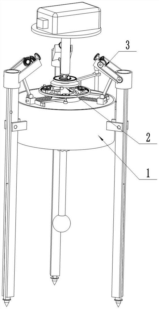
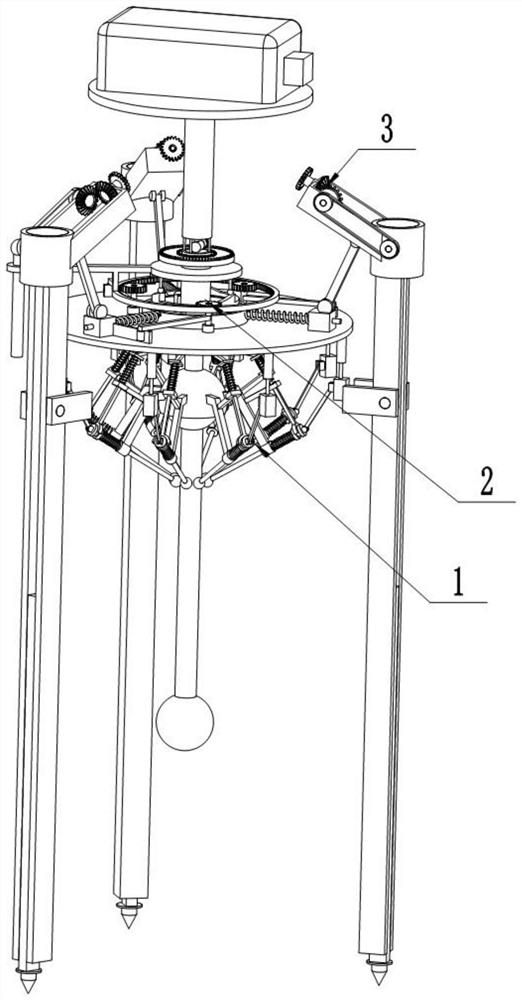
[0037] Example: Reference figure 1 and figure 2 An adjustable engineering surveying and mapping device shown includes a balancing device 1 for keeping the surveying and mapping device stable. The upper end of the balancing device 1 is provided with a locking device 2 for preventing the surveying and mapping device from being adjusted during the transfer process. The side of the locking device 2 is provided. A height-adjustable support device 3 for supporting the entire surveying and mapping device is provided.

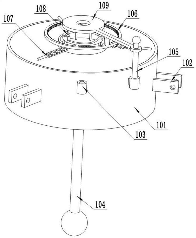
[0038] refer to figure 1 , image 3 and Figure 4 The balance device 1 shown includes a balance shell 101, three groups of turrets 102 are arranged on the balance shell 101, two sets of bolt holes 103 are arranged on the balance shell 101, and a measuring disc 210 is arranged on the upper end of the balance shell 101, and the measuring disc 210 is rotatably installed. There is a connecting rod 109, a plug 105 is arranged in the plug hole 103, and the plug 105 is c...


PUM


Abstract

The invention discloses an adjustable engineering surveying and mapping device and a using method thereof, and relates to the technical field of engineering surveying and mapping devices.The adjustable engineering surveying and mapping device comprises a balancing device used for keeping the surveying and mapping device stable, a gravity ball is arranged in the balancing device, and when the device is not kept horizontal, the gravity ball swings; a pressure sensor is triggered through swinging so as to judge the inclination direction and angle, a locking device used for preventing the surveying and mapping device from being adjusted in the transferring process is arranged at the upper end of the balancing device, and the locking device has the function of locking the gravity ball, so that the gravity ball is prevented from swinging in the transferring process; a height-adjustable supporting device used for supporting the whole surveying and mapping device is arranged on the side edge of the locking device, a liftable supporting head is arranged on the supporting device, the height is automatically adjusted according to the deviation angle and orientation, the deviation angle and orientation of the surveying and mapping device can be judged through a gravity ball, and the surveying and mapping device is automatically corrected.

Description

technical field [0001] The present invention designs the technical field of engineering surveying and mapping devices, in particular to an adjustable engineering surveying and mapping device. Background technique [0002] Surveying and mapping engineering mainly refers to measuring various information of space and the earth and drawing topographic maps of various information, taking the shape, size and gravitational field of the earth and other planets as the research objects. Various ground features, landforms and underground geological structures, hydrology, minerals, etc., such as mountains, rivers, houses, roads, vegetation, etc., usually before developing a virgin land or carrying out large-scale engineering construction, a surveying and mapping engineer must measure and draw a topographic map. And provide other information, and then we can make decisions, planning and design, so surveying and mapping work is very important. Usually the maps and traffic and tourism maps...

Claims


Application Information

Patent Timeline
Patent Type & Authority Applications(China)
IPC IPC(8): F16M11/04F16M11/14F16M11/16F16M11/18F16M11/32G01C15/00
CPCF16M11/04F16M11/14F16M11/16F16M11/18F16M11/32G01C15/00
Inventor 褚会鹃
Owner 褚会鹃
Learn More