
Data processing method for wireless sensor network node positioning

A technology of wireless sensors and network nodes, which is applied in the directions of location-based services, network topology, wireless communication, etc., can solve the problems of location errors of nodes with positioning, affecting positioning accuracy, and costing space overhead, achieving good accuracy and simple calculation. , the effect of small time and space cost

Active Publication Date: 2022-07-12
SUN YAT SEN UNIV
View PDF6 Cites 0 Cited by
  • Summary
  • Abstract
  • Description
  • Claims
  • Application Information

AI Technical Summary

Problems solved by technology

This patent filters the RSSI signal through the Kalman filter, and then selects the three RSSI signals with the largest values ​​for positioning. Since the filtering can only eliminate the influence of some predictable noise, the noise that cannot be determined cannot be excluded. Therefore, based on Noisy RSSI data for positioning will cause position errors with positioning nodes, affecting positioning accuracy, and filtering requires a large amount of RSSI data, resulting in large time and space overheads

Method used


Image

  • Data processing method for wireless sensor network node positioning
  • Data processing method for wireless sensor network node positioning
  • Data processing method for wireless sensor network node positioning

Examples


Embodiment 1

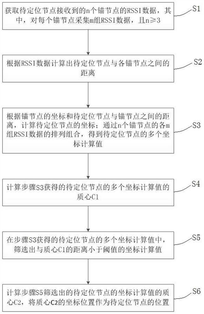
[0056] like figure 1 As shown, a data processing method for wireless sensor network node positioning according to a preferred embodiment of the present invention includes the following steps:

[0057] S1. Acquire RSSI data of n anchor nodes received by the node to be located, wherein m groups of RSSI data are collected for each anchor node, and n≥3;

[0058] S2. Calculate the distance between the node to be located and each anchor node according to the RSSI data;

[0059] S3. Calculate the coordinates of the node to be located according to the coordinates of the anchor node and the distance between the node to be located and the anchor node; obtain multiple coordinates of the node to be located through the arrangement and combination of each m group of RSSI data of the n anchor nodes. value;

[0060] S4, calculating the centroid C of the multiple coordinate calculation values ​​of the nodes to be located obtained in step S3 1 ;

[0061] S5. From the plurality of coordinate...

Embodiment 2

[0066] The difference between this embodiment and the first embodiment is that, on the basis of the first embodiment, this embodiment further describes step S3 and step S6.

[0067] In this embodiment, in step S3, the coordinates of the node to be located are calculated by the ranging positioning method, that is, the coordinates of the node to be located are obtained according to the distance between the anchor node and the node to be located. Specifically, the present embodiment calculates the coordinates of the node to be located according to the three-sided positioning method, and obtains The calculated coordinates of the nodes to be located. Optionally, n=3, m=10 in this embodiment; that is, this embodiment acquires RSSI data for three anchor nodes, acquires 10 sets of RSSI data for each anchor node, and obtains 10 3 The calculated coordinates of the nodes to be located.

[0068] In addition, in this embodiment, in step S3, the centroid C is 1 is calculated as follows:...

Embodiment 3

[0081] The difference between this embodiment and the second embodiment is that, on the basis of the second embodiment, this embodiment further describes step S5.

[0082] In this embodiment, in step S5 , the threshold value is less than half of the distance between the two coordinate calculated values ​​that are farthest apart from among the coordinate calculated values ​​of the nodes to be located obtained in step S3 . In order to ensure the positioning accuracy, the selection of the threshold as the basis for the selection of coordinate calculation values ​​is very important. If the threshold is too large, the effect on noise will not be significantly reduced; if the threshold is too small, the error of the second centroid calculation will be too large, and new errors will be introduced.

[0083] Specifically, the threshold value of this embodiment is a quarter of the distance between the two coordinate calculation values ​​that are farthest apart among the coordinate calcu...


PUM


Abstract

The invention relates to the technical field of wireless sensor networks, and discloses a data processing method for wireless sensor network node positioning, which comprises the following steps of: calculating coordinate calculation values of a plurality of possible positions of a node to be positioned according to RSSI (Received Signal Strength Indicator) data of a plurality of anchor nodes received by the node to be positioned; the method comprises the following steps: calculating a mass center C1 of a plurality of coordinate calculation values, screening out the coordinate calculation values of which the distances to the mass center C1 are smaller than a threshold value, calculating a mass center C2 of the screened coordinate calculation values, and taking the coordinate position of the mass center C2 as the position of a node to be positioned, namely, calculating a plurality of possible positions of the node to be positioned by utilizing a plurality of groups of RSSI data. And the possible positions are further calculated and screened. Compared with the prior art, the received RSSI data are not directly processed, the coordinate calculation value obtained through calculation according to the received RSSI data is processed, precision is good, calculation is easy and convenient, and time and space cost is smaller.

Description

technical field [0001] The present invention relates to the technical field of wireless sensor networks, in particular to a data processing method for wireless sensor network node positioning. Background technique [0002] Wireless sensor networks (WSNs) are known as one of the 21 most influential technologies in this century, and belong to the cross-cutting frontiers of many disciplines such as computer, communication and mathematics. It is a self-organizing data processing network formed by a plurality of sensor nodes with certain functions arranged in the monitoring area through data collection, data transmission and other methods. Through the dense deployment of sensor nodes in the network, data collection and quantification, data aggregation and data transmission operations can be realized. As a modern intelligent network, wireless sensor network has been widely used in military, Internet of Things, environmental monitoring, modern transportation (such as shared bicycl...

Claims


Application Information

Patent Timeline
Patent Type & Authority Applications(China)
IPC IPC(8): H04W4/02H04W64/00H04W84/18H04L5/00
CPCH04W4/023H04W4/025H04W84/18H04W64/006H04L5/0048Y02D30/70
Inventor 刘星成林浩刘异橦
Owner SUN YAT SEN UNIV
Learn More