
Terrain flatness measuring device for territorial space planning

A technology of space planning and measuring device, which is applied in the direction of measuring device, spray device, liquid spray device, etc., can solve problems such as reducing detection efficiency, and achieve the effect of improving detection efficiency and convenient cleaning.

Active Publication Date: 2022-03-29
山东兰图地理信息科技有限公司
View PDF16 Cites 3 Cited by
  • Summary
  • Abstract
  • Description
  • Claims
  • Application Information

AI Technical Summary

Problems solved by technology

[0004] The purpose of the present invention is to provide a terrain flatness measurement device for national land space planning, to solve the problem that when the reference file in the prior art detects that the ground flatness deviates, the device needs to be stopped and the results checked by the staff. Record technical issues that reduce detection efficiency

Method used


Image

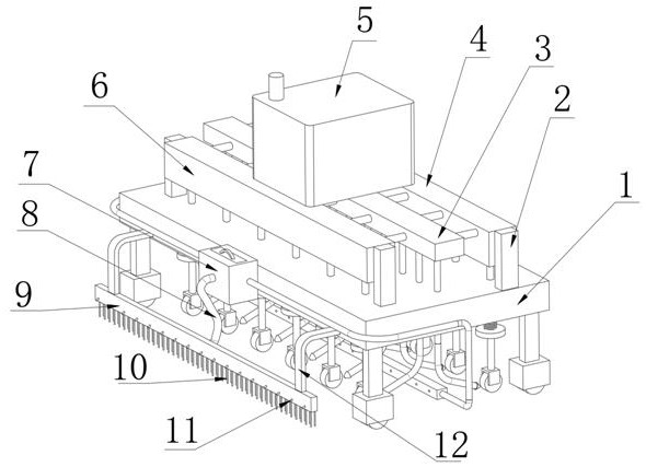
  • Terrain flatness measuring device for territorial space planning
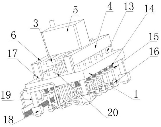
  • Terrain flatness measuring device for territorial space planning
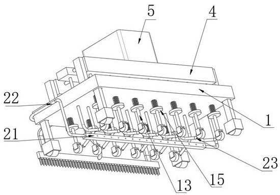
  • Terrain flatness measuring device for territorial space planning

Examples


Embodiment Construction

[0030] The technical solutions of the present invention will be clearly and completely described below in conjunction with the accompanying drawings. Apparently, the described embodiments are some of the embodiments of the present invention, but not all of them.

[0031] The components of the embodiments of the invention generally described and shown in the figures herein may be arranged and designed in a variety of different configurations. Accordingly, the following detailed description of the embodiments of the invention provided in the accompanying drawings is not intended to limit the scope of the claimed invention, but merely represents selected embodiments of the invention.

[0032] Based on the embodiments of the present invention, all other embodiments obtained by persons of ordinary skill in the art without making creative efforts belong to the protection scope of the present invention.

[0033]In the description of the present invention, it should be noted that the ...


PUM


Abstract

The invention discloses a terrain flatness measuring device for territorial space planning, and relates to the technical field of terrain flatness measurement, the terrain flatness measuring device comprises a base, a testing mechanism and a marking mechanism, the testing mechanism and the marking mechanism are both located below the base, and second supporting blocks are installed at the two ends of one side of the outer wall of the top of the base. And second fixed shells are mounted on the outer walls of the opposite ends of the two second supporting blocks. The distance between the distance sensor and the bottom of the base can be measured through the distance sensor arranged on the mounting ring, so that the flatness can be calculated, the detection pulleys on the two sides are not located on the same straight line, the ground can be fully and comprehensively measured, and by arranging the base and the limiting rod, the flatness of the ground can be accurately measured. An arc-shaped rubber block, an arc-shaped rod, a ventilation shell and bristles can push and clean the ground to be measured, and the situation that chippings influence walking of a detection pulley, and consequently the detection result is influenced is avoided.

Description

technical field [0001] The invention relates to the technical field of terrain flatness measurement, in particular to a terrain flatness measurement device for land space planning. Background technique [0002] Land space planning is the guideline for national space development, the space blueprint for sustainable development, and the basic basis for various development, protection and construction activities. Establish a national land space planning system and supervise its implementation, integrate the main functional area planning, land use planning, urban and rural planning and other spatial planning into a unified land space planning, realize "multi-plan integration", and strengthen the guidance of land space planning for various special plans Constraint effect, in land spatial planning, it is necessary to measure the terrain flatness. [0003] A Chinese invention patent with the publication number CN113155001A discloses a flatness measuring device for construction eng...

Claims


Application Information

Patent Timeline
Patent Type & Authority Applications(China)
IPC IPC(8): G01B21/30B05B9/04
CPCG01B21/30B05B9/0403
Inventor 谷荣全于淑华徐勇升
Owner 山东兰图地理信息科技有限公司
Learn More