A Geographical Information System of Drainage Network

A technology of geographic information system and drainage pipe network, applied in geographic information database, data processing application, special data processing application, etc., can solve the problems of information inconsistent with the status quo, incomplete data, low pipeline planning efficiency, etc., and achieve convenient management work , the effect of improving management efficiency

Active Publication Date: 2022-05-27
创辉达设计股份有限公司
View PDF6 Cites 0 Cited by
  • Summary
  • Abstract
  • Description
  • Claims
  • Application Information

AI Technical Summary

Problems solved by technology

[0002] With the rapid development of my country's infrastructure construction, the expansion and transformation of urban underground pipelines have increased dramatically, and its comprehensive management problems have become increasingly prominent. First of all, underground pipelines are a huge and complex system composed of many different pipelines and facilities. , charts and other paper media record keeping and management, incomplete data, inconvenient query, slow update speed, resulting in information inconsistent with the status quo
[0003] However, the pipeline information of the current underground pipeline system is stored in the database in two-dimensional form. The pipeline planning for real-time terrain is inefficient, and the operation status of the pipeline network cannot be well analyzed and evaluated. Water quality, The water level is detected, and the efficiency of real-time early warning, emergency command and rapid disposal in the event of a major disaster is low

Method used


Image

  • A Geographical Information System of Drainage Network
  • A Geographical Information System of Drainage Network
  • A Geographical Information System of Drainage Network

Examples


Embodiment Construction

[0046] In order to make the objectives, technical solutions and advantages of the present application more clear, the present application will be further described in detail below with reference to the accompanying drawings and embodiments. It should be understood that the specific embodiments described herein are only used to explain the present application, but not to limit the present application.

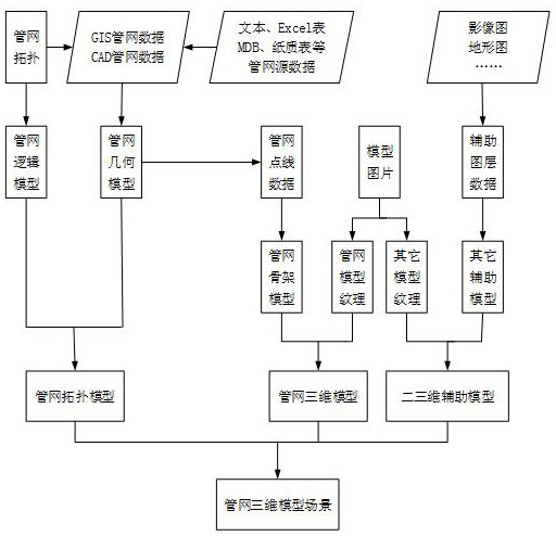
[0047] In one embodiment, as figure 1 As shown, a drainage pipe network geographic information system is provided. The system includes a user layer, an application layer, a support layer, a data layer and an infrastructure layer; the user layer, the application layer, the support layer, the data layer and the infrastructure layer are connected through an interface .

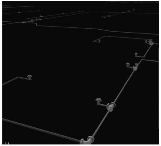
[0048] The application layer is used to provide users of the drainage pipe network geographic information system with comprehensive pipe network information services from two-dimensional to three-dimensional, incl...


PUM


Abstract

This application relates to a geographic information system of drainage pipe network. The system includes a user layer, an application layer, a support layer, a data layer, and an infrastructure layer; the application layer is used to provide comprehensive pipe network information services from two-dimensional to three-dimensional for users of the drainage pipe network geographic information system, and the support layer is used to realize The unified management and release of various data provides basic operation support for the operation of various business application systems in the drainage network. The data layer includes a 3D model database. According to 2D pipeline data and 3D modeling technology, 3D pipeline data is obtained and stored. 3D pipeline data for a drainage network. The system can improve the management efficiency of drainage pipe network by adopting two-dimensional to three-dimensional integrated design.

Description

technical field [0001] The present application relates to the field of computer technology, and in particular, to a geographic information system for a drainage pipe network. Background technique [0002] With the rapid development of infrastructure construction in my country, the expansion and renovation of urban underground pipelines has increased dramatically, and the comprehensive management problem has become increasingly prominent. First, underground pipelines are huge and complex systems composed of various pipelines and facilities. , charts and other paper media record preservation and management, incomplete data, inconvenient inquiries, slow update speed, resulting in information inconsistent with the status quo. [0003] However, the pipeline information of the current underground pipeline system is stored in the database in two-dimensional form. The pipeline planning efficiency for real-time terrain is low, and the operation status of the pipeline network cannot be...

Claims


Application Information

Patent Timeline
Patent Type & Authority Patents(China)
IPC IPC(8): G06F16/29G06Q10/06G06Q50/06
CPCG06F16/29G06Q10/0631G06Q50/06
Inventor 杨相展赵安华王颖曹煌李林杨娜娜陈洪伟胡晓峰
Owner 创辉达设计股份有限公司
Why Eureka
Try Eureka