
Forest fire monitoring system and method based on multi-source satellite remote sensing technology

A satellite remote sensing and satellite technology, which is applied to forest fire alarms, fire alarms that rely on radiation effects, and measuring devices, etc., can solve the problem of inability to compare and analyze multiple times, difficult fire situation, and early detection of forest fires And other issues

Pending Publication Date: 2022-03-01
浙江省气候中心
View PDF5 Cites 7 Cited by
  • Summary
  • Abstract
  • Description
  • Claims
  • Application Information

AI Technical Summary

Problems solved by technology

[0003] Existing forest fire monitoring mainly uses polar-orbiting meteorological satellites for monitoring. In actual operation, there are deficiencies such as low time resolution and inability to compare and analyze multiple times. As a result, it is impossible to detect forest fires early and it is difficult to continuously monitor the fire situation. Tracking, unable to achieve dynamic display of fire development

Method used


Image

  • Forest fire monitoring system and method based on multi-source satellite remote sensing technology
  • Forest fire monitoring system and method based on multi-source satellite remote sensing technology
  • Forest fire monitoring system and method based on multi-source satellite remote sensing technology

Examples


Embodiment Construction

[0075] In order to make the object, technical solution and advantages of the present invention clearer, the present invention will be further described in detail below in conjunction with the accompanying drawings and embodiments. It should be understood that the specific embodiments described here are only used to explain the present invention, not to limit the present invention.

[0076] It is understandable that in the existing technology, forest fire monitoring mainly uses polar-orbiting meteorological satellites for monitoring. In actual operation, there are shortcomings such as low time resolution and inability to compare and analyze multiple times, resulting in the inability to detect forest fires early , and it is difficult to continuously track the fire situation, and it is impossible to realize the dynamic display of fire development.

[0077] In order to solve the above problems, the embodiments of the present invention generate satellite processing data by receivin...


PUM


Abstract

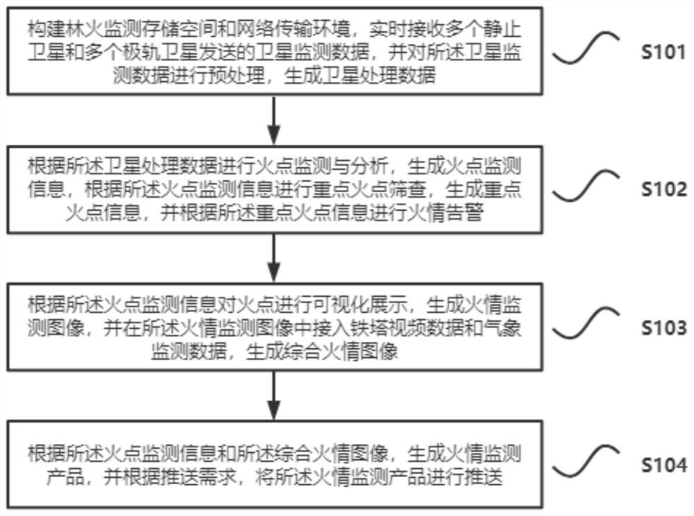
The embodiment of the invention relates to the field of forest fire monitoring, and particularly discloses a forest fire monitoring system and method based on a multi-source satellite remote sensing technology. The method comprises the following steps: receiving satellite monitoring data sent by a plurality of stationary satellites and a plurality of polar orbit satellites in real time to generate satellite processing data; fire point monitoring and analysis are carried out according to the satellite processing data, fire point monitoring information is generated, and fire alarm is carried out according to the key fire point information; and performing visual display on the fire point according to the fire point monitoring information, generating a fire monitoring image, and accessing iron tower video data and meteorological monitoring data to generate a comprehensive fire image. Through advantage complementation between the stationary satellite and the polar orbit satellite, fine, full-coverage and high-frequency monitoring requirements of the forest fire can be met, so that the forest fire can be found as soon as possible, the development situation of the forest fire can be continuously tracked, and dynamic change data of fire development can be acquired and dynamically displayed; and a decision basis is provided for scientific fighting of forest fire.

Description

technical field [0001] The invention belongs to the field of forest fire monitoring, in particular to a forest fire monitoring system and method based on multi-source satellite remote sensing technology. Background technique [0002] With the development of remote sensing technology, satellite remote sensing has been widely used in various industries. The application of satellite remote sensing technology to forest fire monitoring can provide refined, accurate and customized fire monitoring information services for forest fire prevention decision-making, industries, enterprises and other departments. [0003] Existing forest fire monitoring mainly uses polar-orbiting meteorological satellites for monitoring. In actual operation, there are deficiencies such as low time resolution and inability to compare and analyze multiple times. As a result, it is impossible to detect forest fires early and it is difficult to continuously monitor the fire situation. Tracking cannot realiz...

Claims


Application Information

Patent Timeline
Patent Type & Authority Applications(China)
IPC IPC(8): G08B17/00G08B17/12G01W1/02
CPCG08B17/005G08B17/125G01W1/02Y02A90/10
Inventor 贺忠华何月张小伟方贺蔡菊珍
Owner 浙江省气候中心
Learn More