


Quick Research
Generate reliable direction feasibility study reports for your R&D in just a few steps.

Technical Q&A
Discover and master advanced knowledge NOW. Basics, ideas, possibilities, all at once.

Find Solutions
As an expert in R&D theories, this can generate solutions to your technical problems instantly.

Evaluate Feasibility
Analyze your overall solution with one click, know your potential R&D risks in advance.

Monitor Landscape
Get weekly tech updates, stay abreast of the latest tech innovations and key insights.
A town-level tsunami risk assessment method based on Thiessen polygons
A technology of Thiessen polygon and risk assessment, applied in the field of township-level tsunami risk assessment based on Thiessen polygon, can solve the problems of tsunami vulnerability that is not comprehensive enough, lacks fine unit division, and cannot meet the actual needs of township-level disaster reduction departments, etc. Achieve the effects of improving scientificity and operability, ensuring the safety of residents' lives and property, and ensuring high-speed and stable development
- Summary
- Abstract
- Description
- Claims
- Application Information
AI Technical Summary
Problems solved by technology
Method used
Image

Examples
Embodiment 1
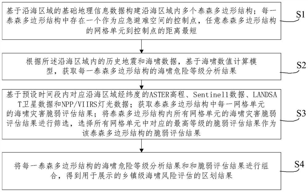
[0070] like Figure 1A , Figure 1B and figure 2 As shown, an embodiment of the present invention provides a town-level tsunami risk assessment method based on Thiessen polygons. The execution subject of the method in this embodiment can be any electronic device, and the method includes the following steps:
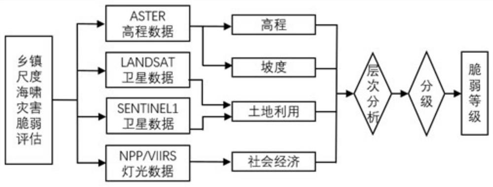
[0071] S1. Construct multiple Thiessen polygonal structures in the coastal area based on the basic geographic information data of the coastal area; each Thiessen polygonal structure has a control point as an emergency refuge space, and the grid cells of any Thiessen polygonal structure to the control point the shortest distance.
[0072] For example, the above-mentioned basic geographic information data includes coastline data, geographic distribution information of township-level settlements, township administrative division data, elevation data, and water depth data.
[0073] Village-level / community-level settlement data is extracted from the geographic distribution...
Embodiment 2
[0085] The results obtained by the method in this embodiment can provide decision support for disaster prevention and mitigation for coastal emergency management departments, and at the same time provide reference for site selection, development planning and regional disaster prevention and mitigation management of major coastal projects, so as to ensure the rapid and stable development of the coastal economy and the lives and properties of residents. Safety.
[0086] The steps of the above-mentioned first embodiment will be described in detail below.
[0087] 201. Collect basic geographic information data of coastal areas; the basic geographic information data includes coastline data, geographic distribution information of township-level settlements, township administrative division data, elevation data, and water depth data, etc.;
[0088] In this embodiment, the coastal area is divided based on the latitude and longitude data to obtain multiple grid units, that is, the coas...
Embodiment 3
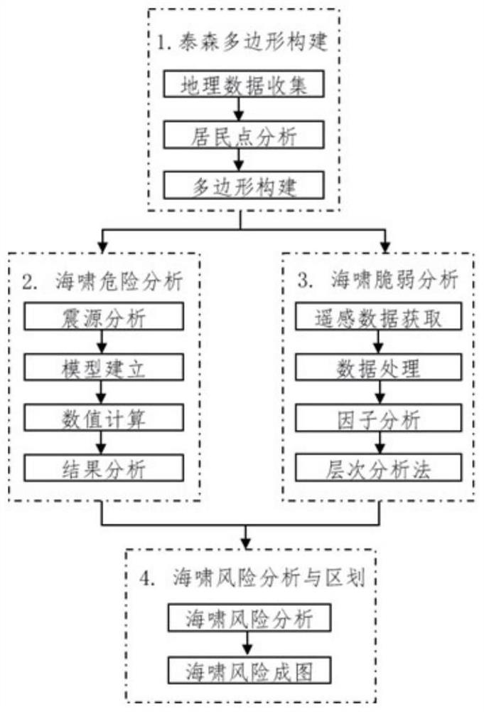
[0138] In order to better understand the contents of the first and second embodiments above, the following is a detailed description from four aspects: Thiessen polygon construction, tsunami risk analysis, tsunami vulnerability analysis and tsunami risk analysis.
[0139] First, the construction of Thiessen polygons
[0140] (1) Data collection
[0141] Collect basic geographic information data such as administrative divisions used in the construction of Tyson polygons. The basic geographic information data includes coastline data, residential distribution data, and township administrative division data.
[0142] (2) Analysis of settlements
[0143] The village (community)-level settlement data is extracted from the settlement distribution data. Important disaster-bearing bodies that may be affected by the tsunami disaster are also added as residential data, such as important factories, tourist areas, ports, and dangerous goods storage places.
[0144](3) Polygon construc...
PUM
 Abstract
Description
Claims
Application Information
 - R&D Engineer
- R&D Manager
- IP Professional
- Industry Leading Data Capabilities
- Powerful AI technology
- Patent DNA Extraction
Browse by: Latest US Patents, China's latest patents, Technical Efficacy Thesaurus, Application Domain, Technology Topic, Popular Technical Reports.
© 2024 PatSnap. All rights reserved.Legal|Privacy policy|Modern Slavery Act Transparency Statement|Sitemap|About US| Contact US: help@patsnap.com