Township-level tsunami risk assessment method based on Thiessen polygon
A Thiessen polygon and risk assessment technology, applied in the field of town-level tsunami risk assessment based on Thiessen polygons, can solve the problems of insufficient tsunami vulnerability, lack of precise unit division, and inability to meet the actual needs of town-level disaster reduction departments, etc. Achieve the effect of ensuring the safety of residents' lives and property, improving scientificity and operability, and ensuring high-speed and stable development
- Summary
- Abstract
- Description
- Claims
- Application Information
AI Technical Summary
Problems solved by technology
Method used
Image


Examples
Embodiment 1
[0070] Such as Figure 1A , Figure 1B and figure 2 As shown, the embodiment of the present invention provides a township-level tsunami risk assessment method based on Thiessen polygons. The execution subject of the method in this embodiment can be any electronic device, and the method includes the following steps:
[0071] S1. Construct multiple Thiessen polygonal structures in the coastal area based on the basic geographic information data of the coastal area; each Thiessen polygonal structure has a control point as an emergency refuge space, and any grid unit of the Thiessen polygonal structure reaches the control point the shortest distance.
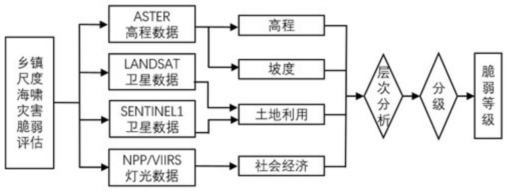
[0072] For example, the above-mentioned basic geographic information data includes coastline data, geographic distribution information of township-level residential areas, township administrative division data, elevation data, and water depth data.
[0073] Village-level / community-level residential data are extracted from the geo...
Embodiment 2
[0085] The results obtained by the method of this embodiment can provide decision-making support for disaster prevention and mitigation for coastal emergency management departments, and at the same time provide reference for site selection, development planning, and regional disaster prevention and mitigation management of major coastal projects, so as to ensure the rapid and stable development of coastal economy and the lives and properties of residents. Safety.
[0086] Each step of the first embodiment above will be described in detail below.
[0087] 201. Collect basic geographic information data in coastal areas; the basic geographic information data includes coastline data, geographical distribution information of township-level residential areas, township administrative division data, elevation data, and water depth data;
[0088] In this embodiment, the coastal area is divided based on latitude and longitude data to obtain multiple grid units, that is, the coastal area...
Embodiment 3
[0138] In order to better understand the content of the first and second embodiments above, the following four aspects will be described in detail from Thiessen polygon construction, tsunami risk analysis, tsunami vulnerability analysis and tsunami risk analysis.
[0139] First, Thiessen polygon construction
[0140] (1) Data collection
[0141] Collect basic geographic information data such as administrative divisions used in the construction of Thiessen polygons. The basic geographic information data includes coastline data, residential distribution data, and township administrative division data.
[0142] (2) Residential analysis
[0143] The village (community) level residential data is extracted from the residential distribution data. Important disaster-affected bodies that may be affected by tsunami disasters are also added as residential data, such as important factories, tourist areas, ports, and dangerous goods storage places.
[0144] (3) Polygon construction
[...
PUM
 Abstract
Description
Claims
Application Information
 - R&D
- Intellectual Property
- Life Sciences
- Materials
- Tech Scout
- Unparalleled Data Quality
- Higher Quality Content
- 60% Fewer Hallucinations
Browse by: Latest US Patents, China's latest patents, Technical Efficacy Thesaurus, Application Domain, Technology Topic, Popular Technical Reports.
© 2025 PatSnap. All rights reserved.Legal|Privacy policy|Modern Slavery Act Transparency Statement|Sitemap|About US| Contact US: help@patsnap.com