
Multi-level multi-thematic spatial data organization and retrieval method and device

A spatial data and multi-level technology, applied in the computer field, can solve the problems of spatial data lack of correlation between layers, topics, lack of organic correlation of spatial data, difficulty in meeting the requirements of integrated analysis, processing and mining of spatial data, etc. , to achieve the effect of integrated collaborative management

Pending Publication Date: 2021-12-14
AEROSPACE INFORMATION RES INST CAS
View PDF0 Cites 2 Cited by
  • Summary
  • Abstract
  • Description
  • Claims
  • Application Information

AI Technical Summary

Problems solved by technology

The organization method of spatial data with layer as the basic unit lacks the organic correlation between levels and themes of spatial data, and it is difficult to meet the requirements of integrated analysis, processing and mining of various types of spatial data across levels and themes.
[0006] In summary, limited by the existing technology, spatial data lacks the correlation between levels and themes

Method used


Image

  • Multi-level multi-thematic spatial data organization and retrieval method and device
  • Multi-level multi-thematic spatial data organization and retrieval method and device
  • Multi-level multi-thematic spatial data organization and retrieval method and device

Examples


Embodiment Construction

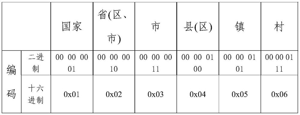
[0074] The specific embodiments of the present invention will be further described below in conjunction with the accompanying drawings. The following examples are only used to more clearly illustrate the technical solutions of the present invention, and cannot limit the protection scope of the present invention with this.

[0075] In order to better explain the present invention, it is first necessary to distinguish two concepts: spatial object and spatial element object.

[0076] Specifically, the spatial object refers to the spatial object in the real geographic world, and the spatial element object refers to the conceptual object mapped in the computer to the spatial object in the real geographic world.

[0077] The multi-level multi-thematic spatial data organization and retrieval method provided by the embodiment of the present invention can be applied to such as figure 1 In the system architecture shown, the system architecture includes a client 100 , a spatial data org...


PUM


Abstract

The embodiment of the invention discloses a multi-level multi-thematic spatial data organization and retrieval method and device. The method comprises the following steps of: acquiring layer information of spatial data; generating an index database according to the layer information; obtaining retrieval information of a user; determining layer information of a space layer to which target spatial data belongs from an index database according to the retrieval information; determining a first space element object set, a first associated layer set and a first associated space element object set corresponding to the target spatial data according to the layer information; and determining a second space element object set, a second association graph layer set and a second association space element object set corresponding to the target space data according to the layer information and a preset space association rule. According to the method, the association of the cross-level and cross-thematic spatial data is realized, the retrieval of the cross-level and cross-thematic spatial data is solved through a spatial data coding backtracking method, a spatial association rule constraint method and a spatial relationship reasoning method, and the integrated collaborative management of the multi-level and multi-thematic spatial data is realized.

Description

technical field [0001] The invention relates to the field of computer technology, in particular to a method and device for organizing and retrieving multi-level and multi-theme spatial data. Background technique [0002] Spatial data is the mapping in the computer of the spatial objects of the real geographical world, and is the conceptual abstraction of the spatial objects of the real world. The real geographic world is complex, and various macroscopic and microscopic geographic phenomena are superimposed and interacted with each other. Therefore, spatial data itself has a multi-level and multi-thematic nature. [0003] The multi-level nature of spatial data refers to the different degrees of abstraction of spatial objects on different scales, reflecting different geographical laws and phenomena. At the data level, it is manifested that spatial objects have different levels of detail and spatial forms at different spatial scales or scales. For example, a house is abstract...

Claims


Application Information

Patent Timeline
Patent Type & Authority Applications(China)
IPC IPC(8): G06F16/245G06F16/29G06F16/28G06F16/22
CPCG06F16/245G06F16/29G06F16/284G06F16/2228
Inventor 任应超张福庆王刚李津平易雄鹰
Owner AEROSPACE INFORMATION RES INST CAS
Learn More