Rapid relocation method for large-scale mapping scene based on point cloud

A repositioning and large-scale technology, applied in the field of robot automatic driving, can solve the problems of reducing the speed of repositioning, the robustness is limited by the environment, and the amount of calculation is large, so as to reduce the amount of calculation, improve the lack of pruning, The effect of reducing the search range

Pending Publication Date: 2021-12-07
CHANGCHUN YIHANG INTELLIGENT TECH CO LTD
View PDF6 Cites 4 Cited by
  • Summary
  • Abstract
  • Description
  • Claims
  • Application Information

AI Technical Summary

Problems solved by technology

The first one relies on GPS positioning to achieve fast positioning. The disadvantage is that GPS can only be used outdoors, and the accuracy is 5-10 meters. For indoor home service robots with centimeter-level accuracy, or where the GPS signal is weak, For example, in the application of buildings and basements, GPS positioning is powerless; the second relies on auxiliary sensors to achieve fast positioning, such as visual sensors assisting laser sensors, but is limited by lighting conditions, and the robustness of its technology is limited by the environment; The three methods require the vehicle to move the vehicle without positioning information, which adds difficulties to the planning and motion control modules, and also adds challenges to the security of the system;
[0006] The fourth method uses the score determination method of multi-resolution sub-map nodes. Although this method does not depend on external conditions, it has a large amount of calculation and is not suitable for large-scale mapping scenarios.
For large-scale mapping occasions, assuming that there are 10,000 key frames, there are also 10,000 nodes, assuming that the tree structure level of 10,000 nodes is sufficient, and the nodes with a similarity greater than 80% to the current 3D point cloud are located in the tree The last node of the tree structure, the algorithm has to traverse most of the nodes of the tree structure almost from the beginning to the end, which greatly reduces the speed of relocation

Method used


Image

  • Rapid relocation method for large-scale mapping scene based on point cloud
  • Rapid relocation method for large-scale mapping scene based on point cloud
  • Rapid relocation method for large-scale mapping scene based on point cloud

Examples


Embodiment Construction

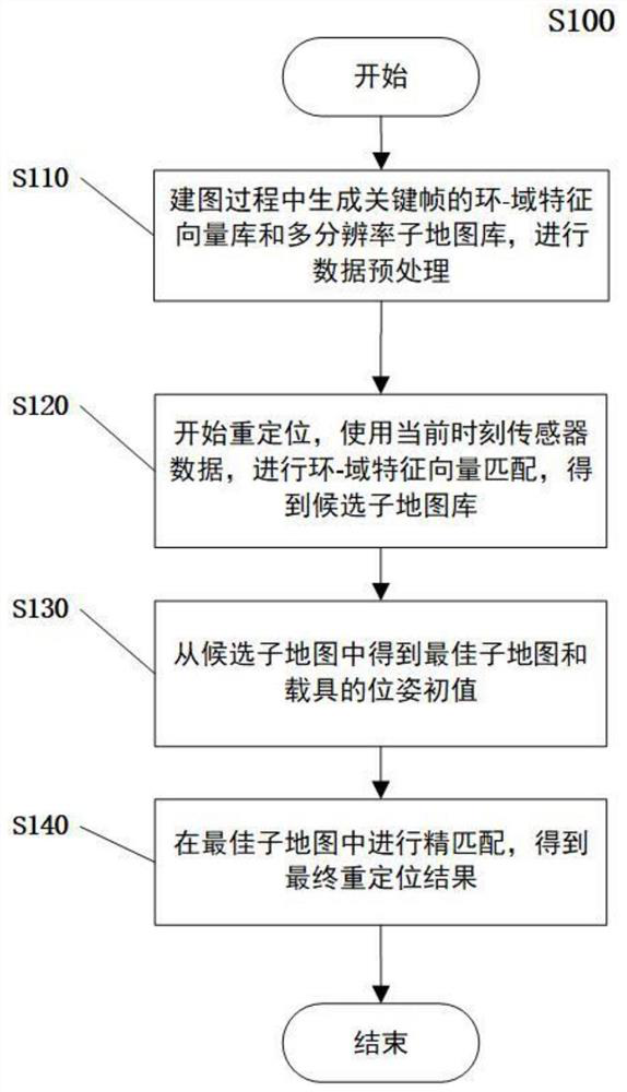
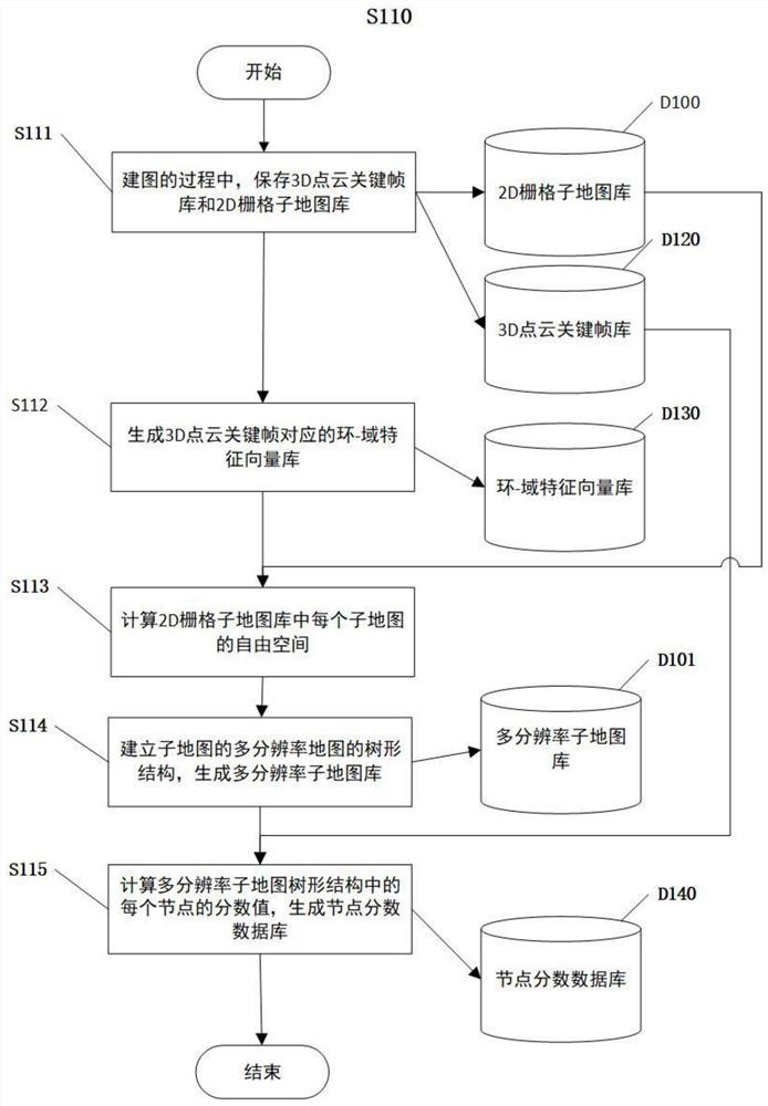
[0059] Below in conjunction with accompanying drawing, the present invention is further explained:

[0060] Design principle of the present invention

[0061] 1. The design principle of the combination of time-sharing calculation and real-time calculation: the time-sharing calculation is to perform data preprocessing during the map building process to generate a node score database; the real-time calculation is to perform relocation without completely relying on It is based on the historical database, but selectively performs real-time calculation of nodes, including real-time calculation of nodes in the first layer, selective calculation of nodes in the middle layer and the last layer. The conditions for real-time calculation of nodes in the middle layer are: everything and history Nodes that are not matched in the library are pruned, and nodes that have been matched are calculated in real time; the condition for real-time calculation of the last layer node is: if the parent ...


PUM


Abstract

The invention discloses a rapid relocation method for a large-scale mapping scene based on a point cloud, and belongs to the technical field of robot automatic driving, and the method comprises the steps: carrying out mapping by using an SLAM technology, in the mapping process, generating a key frame of a 3D point cloud, a corresponding ring-domain feature vector library and a multi-resolution sub-map library, and carrying out the data preprocessing; the data preprocessing comprises the following steps: calculating the score of each node in the tree structure of the multi-resolution sub-map, and generating a node score database; starting repositioning, and performing ring-domain feature vector matching by using sensor data at the current moment to obtain a candidate sub-map library; obtaining the optimal sub-map and the initial pose value of the carrier from the candidate sub-maps; and performing fine matching in the optimal sub-map to obtain a final relocation result. According to the method, the problems that real-time positioning can only be realized by depending on the support of an external environment in the prior art, or the operation data volume is too large during real-time positioning, and the method is not suitable for real-time positioning of a large-scale mapping scene are solved.

Description

technical field [0001] The invention belongs to the technical field of automatic driving of robots, and in particular relates to a fast relocation method for large-scale mapping scenes based on point clouds. Background technique [0002] To realize autonomous positioning of self-driving vehicles or mobile robots, self-driving vehicles or mobile robots need to be used as vehicles, and sensors such as laser radars and cameras are installed on the vehicles for mapping and localization. This process is widely used in the industry It is called SLAM (Simultaneous Localization and Mapping) technology. [0003] After the mapping is completed, use the established existing map to determine the position of the vehicle in the existing map through the current real-time collected sensor data to achieve real-time positioning. [0004] Real-time positioning In actual use, there are two application scenarios. One is that the starting position of the vehicle may be unknown, so it is necessar...

Claims


Application Information

Patent Timeline
IPC IPC(8): G06T17/05G06T11/00G06F16/22G06F16/2455G06F16/29G01C21/30
CPCG06T17/05G06T11/001G06F16/2246G06F16/2455G06F16/29G01C21/30G06T2207/10028
Inventor 张煜东范圣印王璀刘志励李一龙
Owner CHANGCHUN YIHANG INTELLIGENT TECH CO LTD
Why Eureka
Try Eureka