Hyperspectral remote sensing image satellite-ground cooperative atmospheric correction method and system and storage medium

A hyperspectral remote sensing and atmospheric correction technology, which is applied in the field of hyperspectral remote sensing image satellite-terrestrial collaborative atmospheric correction, can solve the problems of low operability, difficult observation of atmospheric state parameters, and difficulty in comparing the accuracy with synchronous observation data, etc. , to achieve the effect of improving accuracy, improving the ability of comprehensive and effective utilization, and improving accuracy and reliability

Pending Publication Date: 2021-11-05
自然资源部国土卫星遥感应用中心
View PDF0 Cites 1 Cited by
  • Summary
  • Abstract
  • Description
  • Claims
  • Application Information

AI Technical Summary

Problems solved by technology

[0005] The existing atmospheric correction methods for hyperspectral remote sensing images have the following problems: (1) Inversion of atmospheric state parameters based solely on hyperspectral remote sensing images is mainly based on empirical models, and the accuracy is difficult to compare with synchronous observation data; (2) It is extremely difficult to observe atmospheric state parameters that have the same imaging area as hyperspectral remote sensing imaging and are strictly synchronized at all times, and the existing technical methods are not very operable

Method used


Image

  • Hyperspectral remote sensing image satellite-ground cooperative atmospheric correction method and system and storage medium
  • Hyperspectral remote sensing image satellite-ground cooperative atmospheric correction method and system and storage medium
  • Hyperspectral remote sensing image satellite-ground cooperative atmospheric correction method and system and storage medium

Examples


Embodiment Construction

[0026] In order to make the purpose, technical solutions and advantages of the embodiments of the present invention more clear, the following will clearly and completely describe the technical solutions of the embodiments of the present invention in conjunction with the drawings of the embodiments of the present invention. Apparently, the described embodiments are some, not all, embodiments of the present invention. All other embodiments obtained by those skilled in the art based on the described embodiments of the present invention belong to the protection scope of the present invention.

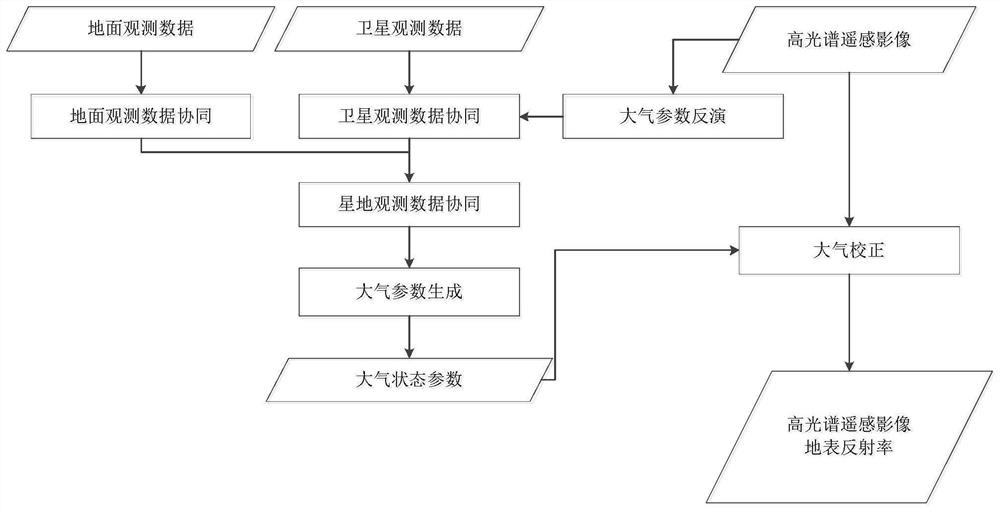
[0027] In one embodiment of the present invention, as figure 1 As shown, a hyperspectral remote sensing image satellite-terrestrial collaborative atmospheric correction method is provided, which includes the following steps:

[0028] Step 1. Obtain ground observation data, satellite observation data and hyperspectral remote sensing image data;

[0029] Among them, the ground observation d...


PUM


Abstract

The invention relates to a hyperspectral remote sensing image satellite-ground collaborative atmospheric correction method and system and a storage medium. The method comprises the following steps: acquiring ground observation data, satellite observation data and hyperspectral remote sensing image data; carrying out ground observation data co-processing on the ground observation data, and carrying out quasi-synchronization on the ground observation data and the hyperspectral remote sensing image; performing satellite observation data co-processing on the hyperspectral remote sensing image data and the satellite observation data to generate atmospheric state parameter data of satellite observation; performing satellite-earth observation data co-processing on the co-processed ground observation data and the atmospheric state parameter data observed by the satellite to generate atmospheric observation data with approximately synchronous observation of the satellite and the ground; and performing atmospheric correction on the hyperspectral remote sensing image data based on the atmospheric observation data to generate atmospheric correction data. According to the invention, the precision and reliability of atmospheric parameter inversion can be improved, and the precision of atmospheric correction processing is improved. The method can be applied to the field of remote sensing image atmospheric correction.

Description

technical field [0001] The invention relates to the field of atmospheric correction of remote sensing images, in particular to a method, system and storage medium for hyperspectral remote sensing image satellite-terrestrial collaborative atmospheric correction under the coordination of satellite-terrestrial observation data. Background technique [0002] The total radiance of the ground target measured by the remote sensor is not a reflection of the real reflected energy of the surface, which includes the radiation energy error caused by atmospheric absorption, scattering and other effects, especially the scattering effect. Atmospheric correction is the process of eliminating these radiation errors caused by atmospheric influences and retrieving the true surface reflectance of ground objects. Atmospheric correction refers to adjusting the measured values ​​of remote sensing images according to the atmospheric conditions to eliminate the influence of the atmosphere and carry ...

Claims


Application Information

Patent Timeline
Patent Type & Authority Applications(China)
IPC IPC(8): G06T5/00G06T7/33G01N21/47
CPCG06T5/005G06T7/337G01N21/4738G06T2207/10032G06T2207/30181G01N2021/1793
Inventor 赵世湖唐新明刘书含胡轶之岳庆兴郭莉刘昌儒
Owner 自然资源部国土卫星遥感应用中心
Why Eureka
Try Eureka