Eureka AIR delivers breakthrough ideas for toughest innovation challenges, trusted by R&D personnel around the world.

Troposphere delay and multi-path error separation method and system of large-height-difference baseline

A multi-path error and tropospheric delay technology, applied in radio wave measurement systems, satellite radio beacon positioning systems, instruments, etc., can solve the problem of difficult to achieve millimeter to sub-millimeter high-precision deformation monitoring targets, unable to independently model and correct, mutual separation, etc.

Pending Publication Date: 2021-09-07
WUHAN UNIV +1
View PDF6 Cites 2 Cited by
  • Summary
  • Abstract
  • Description
  • Claims
  • Application Information

AI Technical Summary

Problems solved by technology

However, in the monitoring of large-scale mountain and hydropower dam landslide hazards, there are often narrow geographical conditions of high mountains. Due to the large difference in elevation between the reference station and the monitoring station, there are relatively serious residual tropospheric delay errors in the observations
In addition, there are inevitably certain reflectors around the GNSS antenna, resulting in cm-level multipath errors in its observations
In the current research, there is no method to separate these two types of errors in GNSS observations, so that independent modeling and correction cannot be done, that is, it is difficult to solve the tropospheric delay and multipath error separation method of the large elevation difference baseline, and it is difficult to achieve millimeter to submillimeter level High-precision deformation monitoring target

Method used


Image

  • Troposphere delay and multi-path error separation method and system of large-height-difference baseline
  • Troposphere delay and multi-path error separation method and system of large-height-difference baseline
  • Troposphere delay and multi-path error separation method and system of large-height-difference baseline

Examples


Embodiment Construction

[0026] The technical solution of the present invention will be described in detail below in conjunction with the accompanying drawings and embodiments.

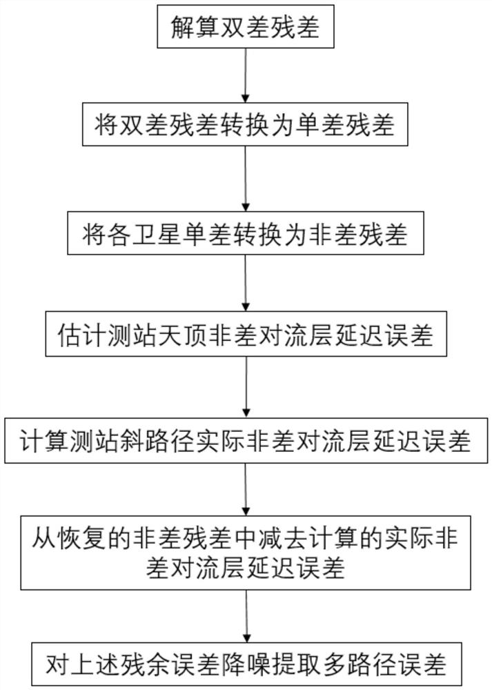
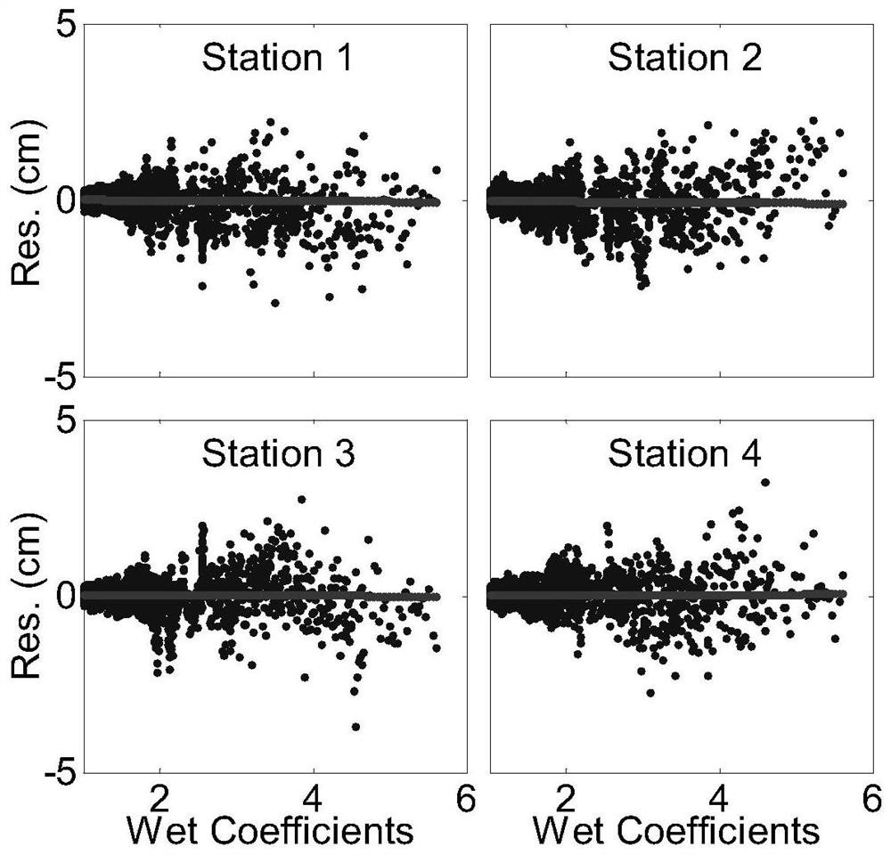
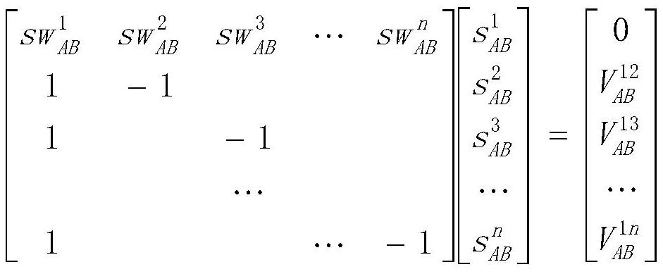
[0027] Under the narrow geographical conditions of high mountains, due to the large difference in elevation at both ends of the station, the tropospheric delay error cannot be completely eliminated by the traditional double-difference method, and there are serious tropospheric delay errors in the residuals of GNSS double-difference observations. In addition, for high-precision GNSS positioning, the impact of cm-level multipath errors cannot be ignored. However, both the multipath error and the tropospheric delay error are altitude-related errors, that is, the low-elevation arc section has a greater influence, while the high-elevation angle arc section has a smaller impact, and the two are difficult to separate from each other. In the embodiment of the present invention, a method for separating GNSS tropospheric delay error an...


PUM


Abstract

The invention provides a troposphere delay and multi-path error separation method and system of a large-height-difference baseline. The method comprises the steps of: firstly recovering a double-difference residual error of an independent baseline of a measurement region into a non-difference residual error of each satellite of each measurement station, namely, solving a group of independent baselines of the measurement region, and converting the double-difference residual error of each baseline into an inter-station single-difference residual error through adding a gravity center reference for the first time; adding the gravity center reference to the single-difference residual error of each baseline again, and recovering the inter-station single-difference residual error to the non-difference residual error of each observation station; then, constructing a non-difference zenith troposphere delay error model of each observation station in combination with a wet delay projection function of a satellite oblique path signal; and finally, subtracting a model calculation value from the non-difference residual error to obtain a multi-path error, thereby realizing separation of the two types of errors. The troposphere delay and multi-path error separation method and the system of the invention support high-precision GNSS short-distance relative positioning under narrow geographical conditions of high mountains.

Description

technical field [0001] The invention belongs to the technical field of GNSS short-baseline high-precision monitoring error correction under high-mountain and narrow geographical conditions, and specifically relates to a method and system for separating tropospheric delay errors and multi-path errors of GNSS oblique path signals based on non-difference residuals. Background technique [0002] In the health monitoring of large bridges, hydropower dams and landslides, high-precision GNSS short-distance relative positioning is currently a more commonly used method. In addition, with the completion of the comprehensive construction of the third-generation Beidou system in my country, Beidou / GNSS will play an increasingly important role in high-precision landslide disaster monitoring and early warning in the future. However, in the monitoring of large-scale mountain and hydropower dam landslide disasters, there are often narrow geographical conditions in high mountains. Due to the...

Claims


Application Information

Patent Timeline
IPC IPC(8): G01S19/37G01S19/22
CPCG01S19/37G01S19/22
Inventor 陈德忠叶世榕夏凤雨
Owner WUHAN UNIV
Why Eureka
Eureka Blog
Learn More