
Unmanned aerial vehicle measurement system for building monitoring

A measurement system and unmanned aerial vehicle technology, which is applied to radio wave measurement systems, measurement devices, navigation through speed/acceleration measurement, etc., can solve problems such as time-consuming and labor-intensive, difficult manual operation, and high labor intensity

Inactive Publication Date: 2021-09-07
邓良波
View PDF1 Cites 0 Cited by
  • Summary
  • Abstract
  • Description
  • Claims
  • Application Information

AI Technical Summary

Problems solved by technology

Manual operation is labor-intensive, with many procedures, time-consuming and labor-intensive, especially for special parts of buildings with particularly complex structures or super high-rise buildings, manual operation is difficult, measurement accuracy cannot be guaranteed, and there are high safety risks

Method used


Image

  • Unmanned aerial vehicle measurement system for building monitoring
  • Unmanned aerial vehicle measurement system for building monitoring

Examples


Embodiment Construction

[0023] The following will clearly and completely describe the technical solutions in the embodiments of the present invention with reference to the drawings in the embodiments of the present invention.

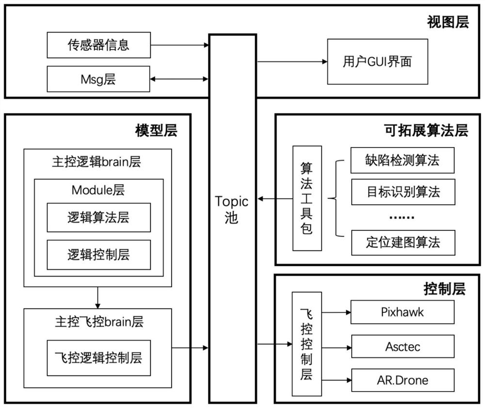
[0024] This embodiment discloses a UAV measurement system for building monitoring. The measurement system is divided into two parts: hardware structure design and software structure design. The principle of hardware structure is as follows: figure 1 As shown, the software structure design is as follows figure 2 As shown, the content of the two parts will be described in detail below in conjunction with the accompanying drawings.

[0025] Among them, the hardware structure includes the UAV platform, the mounted sensors installed on the UAV platform, data transmission equipment and ground workstation; the UAV platform includes the aircraft, flight controller and airborne computing unit. Aircraft, mounted sensors and on-board computing units are used to provide sensor collectio...


PUM


Abstract

The invention relates to an unmanned aerial vehicle measurement system for building monitoring, a hardware structure comprises an unmanned aerial vehicle platform, a mounting sensor installed on the unmanned aerial vehicle platform, a data transmission device and a ground workstation, and the unmanned aerial vehicle platform comprises an aircraft, a flight controller and an airborne arithmetic unit. Data collected by the mounting sensor and flight control information are sent to the ground work station through the data transmission equipment, and the ground work station analyzes, processes and displays the received information in real time; and a software structure adopts a framework combining an MVC framework and an ROS framework and comprises a view layer, a model layer, a control layer and an expandable algorithm layer, and communication interaction among the layers is carried out according to an ROS communication mechanism. The system has the characteristics of high measurement precision, high environmental adaptability and capability of meeting different indoor and outdoor measurement requirements of a building in hardware configuration; and the system has strong developability and expansibility in software structure, and can improve the usability and reliability of the whole test system in a complex environment.

Description

technical field [0001] The invention relates to the technical field of engineering measurement, in particular to an unmanned aerial vehicle measurement system for building monitoring. Background technique [0002] The construction industry is a traditional industry in our country and occupies an important position in the national economy. In the field of construction engineering, the construction unit needs to conduct all-round supervision on the construction progress, construction quality and construction safety throughout the construction cycle. However, the current supervision method mainly relies on manual work. According to the workers using measuring tapes, distance meters and other instruments to measure the building area, floor height and other data, it is judged whether the construction progress is normal and whether the quality is up to standard. Manual operation is labor-intensive, with many procedures, time-consuming and labor-intensive, especially for special p...

Claims


Application Information

Patent Timeline
IPC IPC(8): G01C11/02G01C21/16G01S17/933
CPCG01C11/02G01C21/165G01S17/933
Inventor 何煜邓良波卢宝莉赵国栋邓小强
Owner 邓良波
Learn More