
Remote sensing image fuzzy multi-center supervised classification method and application

A technology for supervised classification, remote sensing imagery, applied in character and pattern recognition, instruments, computer parts, etc., and can solve problems such as limited accuracy

Inactive Publication Date: 2021-09-03
TIANJIN NORMAL UNIVERSITY
View PDF3 Cites 0 Cited by
  • Summary
  • Abstract
  • Description
  • Claims
  • Application Information

AI Technical Summary

Problems solved by technology

Existing single-center classification methods cannot handle this spectral diversity well, resulting in very limited accuracy

Method used


Image

  • Remote sensing image fuzzy multi-center supervised classification method and application
  • Remote sensing image fuzzy multi-center supervised classification method and application
  • Remote sensing image fuzzy multi-center supervised classification method and application

Examples


Embodiment 1

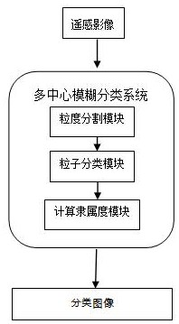
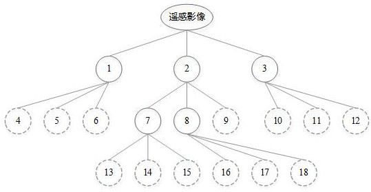
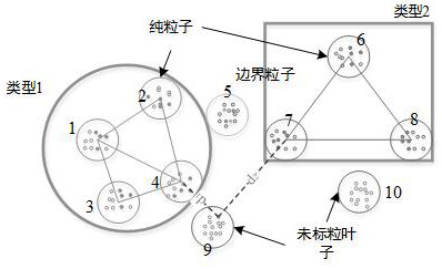
[0031] Let the method use the data set as X, and generate particles directly through the unlabeled hierarchical clustering process. Thus, samples with similar spectral properties occur in a given particle. This hierarchical clustering procedure generates a cluster tree, and then uses labeled samples to classify leaves into three types: pure leaves, impure leaves, and unlabeled leaves. Considering the centers of pure leaves as multiple centers of land cover types, the degree of membership of an unlabeled sample within an impure particle nucleus unlabeled particle is determined by the shortest distance between the sample and the multiple centers. Detailed process such as figure 1 Shown:

[0032] 1. Granularity segmentation module

[0033] To model first- and second-order spectral diversity, the entire dataset is decomposed into particles of similar size in spectral space. On the basis of the FCM algorithm, a hierarchical clustering method using weighted Euclidean distance is...


PUM


Abstract

The invention discloses a remote sensing image fuzzy multi-center supervised classification method and application, and the method comprises the steps: firstly segmenting an image into particles with similar sizes in a spectral space through employing a hierarchical clustering method based on an FCM method, and then carrying out the marking and classification of the particles through employing a marking sample, and dividing the particles into three types: pure particles, impure particles, and unmarked particles, wherein the center of each pure particle represents a spectrum center of each land coverage type, the spectrum diversity of each land coverage type is represented by the centers, and the centers of each type are stored by a coverage tree; and thirdly, determining the membership degree of each unmarked sample belonging to each land coverage type by the nearest pure particles. Experimental results show that the supervised classification method realizes multi-center expression of complex remote sensing data, describes diversity of remote sensing data spectrums, and further improves precision and reliability of remote sensing classification.

Description

[0001] Fund project: This application is supported by the National Natural Science Foundation of China (41971410). technical field [0002] The present invention relates to fuzzy supervised classification, non-supervised classification and semi-supervised methods of remote sensing data in remote sensing science, and more specifically relates to multi-spectral or hyperspectral remote sensing data, using multi-center to express the spectral diversity of geographical phenomena, and then using multi-center A multi-center classification method to calculate the membership degree of pixels in remote sensing data and determine the category of pixels. Background technique [0003] Ambiguity is an inherent uncertainty that widely exists in geographic worlds such as wetlands and forests, and poses great challenges when processing and analyzing multispectral remote sensing data. In recent years, fuzzy sets have been widely used in fuzzy land cover classification because they can express...

Claims


Application Information

Patent Timeline
IPC IPC(8): G06K9/62G06K9/00G06K9/34
CPCG06F18/231G06F18/24
Inventor 郭继发
Owner TIANJIN NORMAL UNIVERSITY
Learn More