
Engineering investigation and exploration data acquisition system and method

A data acquisition system and engineering survey technology, which is applied to the automatic control system of drilling, earthwork drilling, measurement, etc., can solve the problems of low technical level of engineering survey drilling rigs, no obvious improvement, fraud, etc.

Pending Publication Date: 2021-08-31
BGI ENG CONSULTANTS
View PDF0 Cites 2 Cited by
  • Summary
  • Abstract
  • Description
  • Claims
  • Application Information

AI Technical Summary

Problems solved by technology

However, due to the influence of various factors, the development level of the most commonly used drilling rigs in the geotechnical engineering survey industry lags behind the current social science and technology level.
[0003] At present, there are only a few large-scale survey units in the country that have begun to focus on the development and innovation of survey drilling rigs. However, due to the fact that very few personnel in survey units have professional backgrounds such as machinery and automation, the current technical level of survey drilling rigs has not improved significantly. ; For engineering equipment manufacturers, due to the needs of the business market, they put their main research and development energy on large-scale construction machinery such as rotary drilling rigs and crane equipment, and on small drilling rigs used in geotechnical engineering investigations and their operating conditions. little or no consideration
These two aspects lead to the low technical level of engineering survey drilling rigs, there are a lot of error-prone problems, and even room for falsification, which has a very negative impact on the accuracy and objectivity of engineering survey first-hand information.

Method used

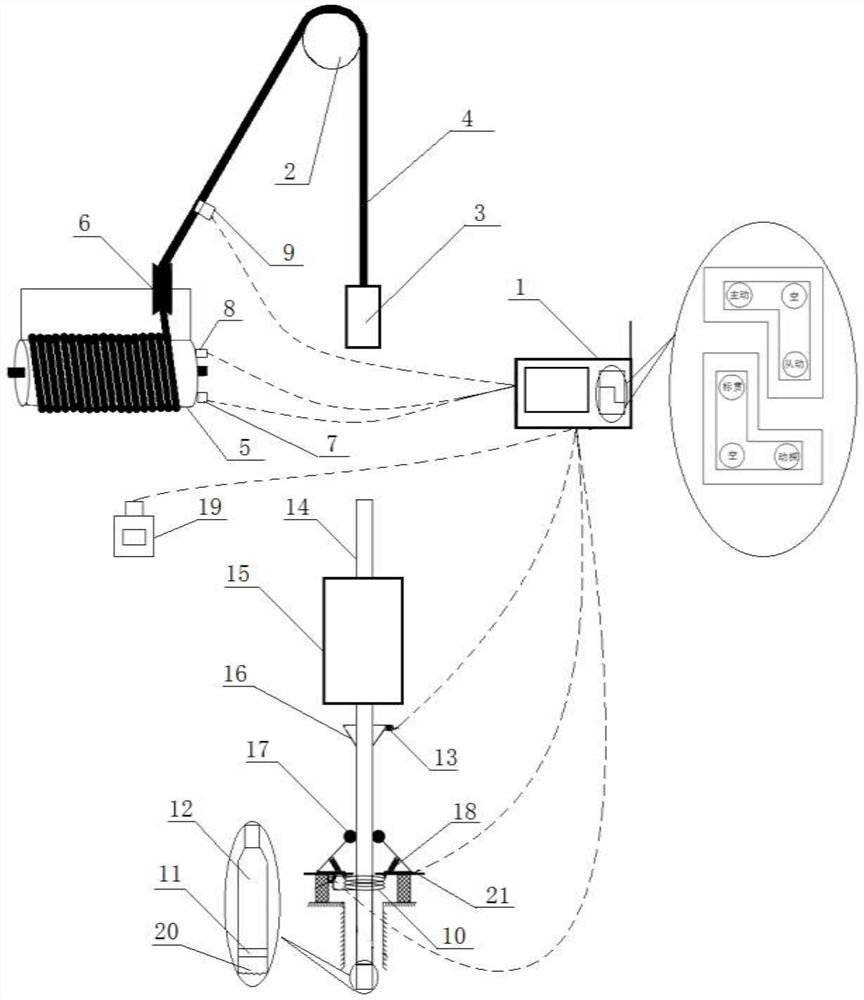
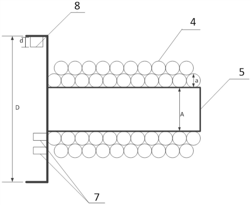
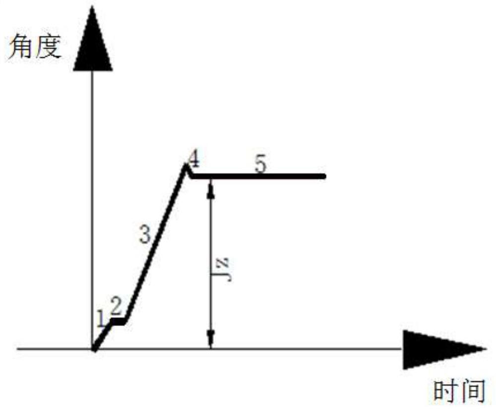

Image

  • Engineering investigation and exploration data acquisition system and method
  • Engineering investigation and exploration data acquisition system and method
  • Engineering investigation and exploration data acquisition system and method

Examples


Embodiment Construction

[0046] The principles and features of the present invention are described below in conjunction with the accompanying drawings, and the examples given are only used to explain the present invention, and are not intended to limit the scope of the present invention.

[0047] Such as figure 1 Shown, a kind of engineering survey exploration data collection system, engineering survey exploration data collection system is used for collecting the engineering survey exploration data of drilling rig in drilling process, described drilling rig comprises fixed pulley 2, lifter 3, suspension rope 4 and Drilling tool, wherein, the drilling tool includes a drill pipe 14, a core pipe 12 and a drill bit 20; the engineering survey and exploration data acquisition system includes a winch, an electromagnetic induction device, a hammer number measuring device, a penetration depth measuring device and an integrated control instrument 1 ; The winch includes a drum 5, the winch is provided with a cab...


PUM


Abstract

The invention relates to an engineering investigation and exploration data acquisition system and method. The engineering investigation and exploration data acquisition system comprises a winch, an electromagnetic induction device, a hammering number metering device, a penetration depth measuring device and a comprehensive control instrument; a winding displacement device is arranged on the winch, a lifting rope penetrates through a fixed pulley and is wound on a roller of the winch through the winding displacement device, a metering roller and a photoelectric sensor probe group are arranged on the side wall of the roller, and a tension sensor is arranged on the lifting rope. The electromagnetic induction device comprises a closed solenoid coil and a magnet, the closed solenoid coil is fixedly installed at an orifice of a drill hole, and the magnet is installed at the tail end of a core barrel of a drilling tool penetrating through the closed solenoid coil. The hammering number metering device comprises a proximity sensor, and the proximity sensor is fixed to a drill rod of the drilling tool. The penetration depth measuring device comprises a meter counting wheel and a spring, the meter counting wheel is hinged to the orifice of the drill hole through the spring and tightly attached to the drill rod, and a pull rope type displacement sensor is arranged in the meter counting wheel. According to the engineering investigation and exploration data acquisition system and method, engineering investigation and exploration data can be accurately and conveniently obtained.

Description

technical field [0001] The invention relates to the field of data acquisition, and in particular to an engineering survey data acquisition system and method. Background technique [0002] From the development of human society to the progress of all walks of life, it is inseparable from the innovation of its tools and equipment. As one of the five parties responsible for engineering construction, the geotechnical engineering survey industry itself belongs to the technical service industry. Specifically, the substantive work done by the geotechnical engineering survey industry is to reveal the geotechnical engineering, engineering geology, hydrogeology and other conditions of the site, and provide the first-hand information needed for engineering construction for later design and construction. Drilling is the most commonly used method of geotechnical engineering investigation. Therefore, for the geotechnical engineering investigation industry, the development level of drillin...

Claims


Application Information

Patent Timeline
IPC IPC(8): E21B47/04E21B47/092E21B19/084E21B25/00E21B44/00
CPCE21B19/084E21B25/00E21B44/00E21B47/04E21B47/092
Inventor 周宏磊马秉务耿一然王珂李正平路永平蒙思宇孙猛侯东利
Owner BGI ENG CONSULTANTS
Learn More