
Passive telemetry robot based on live-action three-dimensional map and measurement method

A technology of three-dimensional maps and robots, which is applied in the field of real-scene three-dimensional map surveying and mapping, can solve the problems of not being able to identify targets, not being able to identify and track targets, and being unusable

Pending Publication Date: 2021-06-11
江苏如是地球空间信息科技有限公司
View PDF1 Cites 2 Cited by
  • Summary
  • Abstract
  • Description
  • Claims
  • Application Information

AI Technical Summary

Problems solved by technology

[0002] At present, the technologies used to measure the three-dimensional geodetic coordinates of the target mainly include the following types: GPS positioning technology, laser ranging positioning technology, microwave ranging positioning technology, ultrasonic positioning technology and RFID positioning technology; the above technologies exist in actual use. There are some defects, such as GPS positioning technology and RFID positioning technology need to install equipment on the target, if no chip is installed on the target in advance, GPS positioning technology and RFID positioning technology cannot be used; while laser ranging positioning technology, microwave ranging positioning technology Ultrasonic positioning technology and ultrasonic positioning technology need to emit electromagnetic waves to the target, and calculate the coordinates of the target through the echo signal. When measuring, it is necessary to aim at the target in advance, but it cannot identify the target, track the target, and cannot know the precise position information of the target, let alone know The real environment around the target location
[0003] For example, the patent application number CN201010590581.0 proposes a method for spatial three-dimensional measurement based on laser point cloud and real scene images, which consists of high-precision laser scanners, high-speed digital imaging equipment, DGPS / IMU direct orientation and positioning equipment and industrial control computers. The mobile measurement system collects real scene images, laser point clouds and positioning and orientation data at the same time; the working principle of the high-precision laser scanner is to rotate the narrow beam emitted by the laser pulse emitter rapidly and orderly through two synchronous mirrors The laser pulses sweep across the measured area in turn, and measure the time (or phase difference) elapsed for each laser pulse from sending out through the surface of the measured object and returning to the instrument to calculate the distance, and the ultrasonic positioning distance is relatively short. This measurement method cannot identify and Track the target and identify the real environment around the target location
[0004] The above technologies are extremely inconvenient for applications in land control, river channel monitoring, precision agriculture, traffic monitoring, public security prevention and control, water law enforcement, forest resource inventory, etc.

Method used


Image

  • Passive telemetry robot based on live-action three-dimensional map and measurement method
  • Passive telemetry robot based on live-action three-dimensional map and measurement method
  • Passive telemetry robot based on live-action three-dimensional map and measurement method

Examples


Embodiment Construction

[0058] The technical solutions of the present invention will be described below in conjunction with the accompanying drawings, as clearly, the described embodiments are merely embodiments of the invention, not all of the embodiments. Based on embodiments of the present invention, there are all other embodiments obtained without making creative labor without making creative labor.

[0059] The present invention will be further described in detail below with reference to the accompanying drawings.

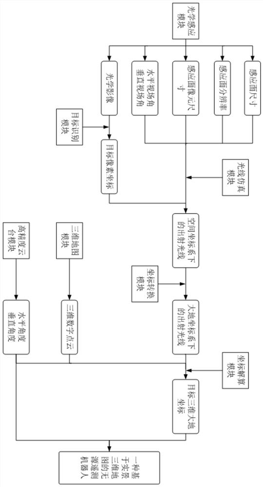
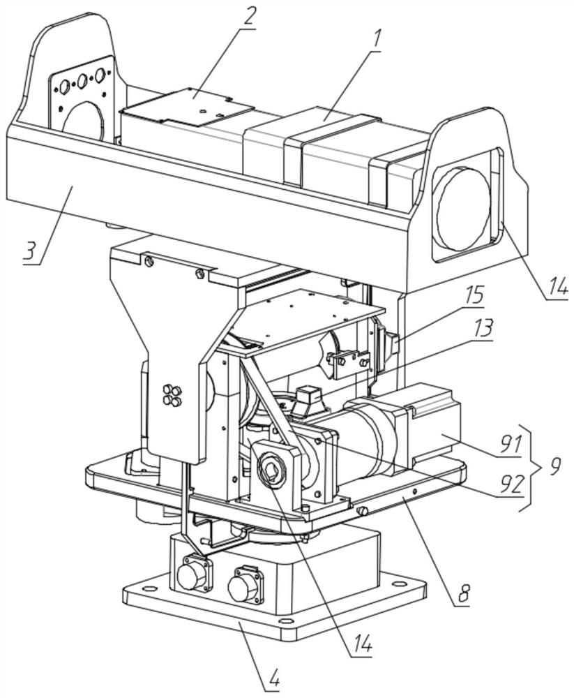
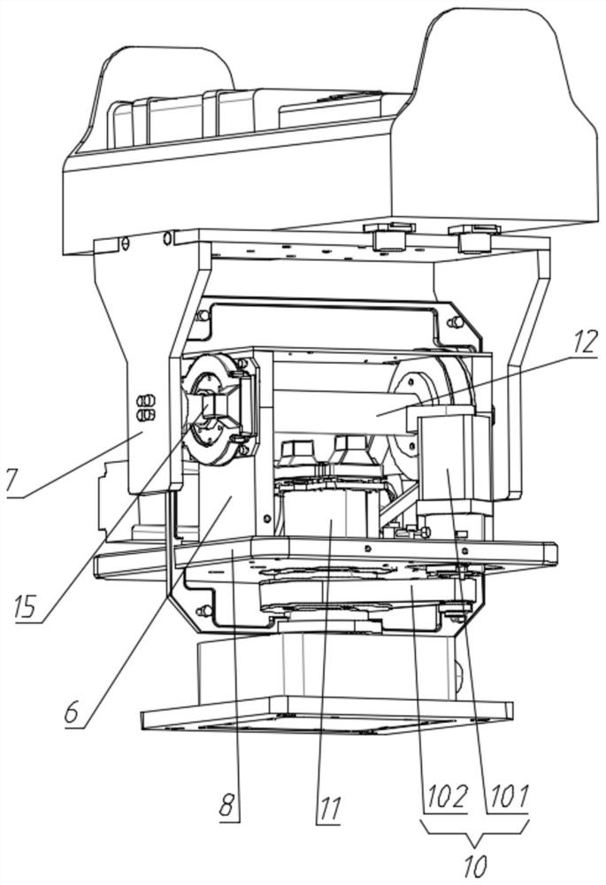
[0060] Such as Figure 1 to 4 As shown, a passive telemetry robot based on a real-view 3D map, including information acquisition modules and data centers, and the information acquisition module is connected to the data center through a communication network.

[0061] The information acquisition module includes an optical sensing module and a high-precision cloud block module, which is disposed on a high precision cloud block module;

[0062] The optical sensing module and the high-precisi...


PUM


Abstract

The invention discloses a passive telemetry robot based on a live-action three-dimensional map and a measurement method, which aim to identify, position and track a target, obtain accurate three-dimensional geodetic coordinates of the tracked target in real time through a real map and a live-action image, visualize the real environment around the tracked target, visually observe the real environment where the tracked target is located, pre-warning related personnel and reminding to make decisions. The method can be widely applied to the fields of land management and control, river monitoring, precision agriculture, traffic monitoring, public security prevention and control, water administration law enforcement, forest resource checking and the like.

Description

Technical field [0001] The present invention relates to the field of real three-dimensional map, and more particularly to a passive telemetry robot and measurement method based on a real-view 3D map. Background technique [0002] At present, the technologies of three-dimensional coordinates for measuring the target mainly include the following: GPS positioning technology, laser ranging positioning technology, microwave ranging positioning technology, ultrasonic positioning technology, and RFID positioning techniques, the above technology exists in actual use. Some defects, such as GPS positioning techniques, and RFID positioning techniques need to be installed on the target. If the target is not installed in advance, the GPS positioning technology and RFID positioning techniques cannot be used; while laser ranging positioning technology, microwave ranging positioning Techniques and ultrasonic positioning techniques require electromagnetic waves to the target, through the echo sig...

Claims


Application Information

Patent Timeline
Patent Type & Authority Applications(China)
IPC IPC(8): G01C11/00G01C11/02G01C11/12F16M11/08F16M11/10F16M11/18G05D1/12
CPCF16M11/08F16M11/10F16M11/18G01C11/00G01C11/02G01C11/12G05D1/12Y02A40/10Y02A90/30
Inventor 何伍斌方永谢务晴柳黎许凯华
Owner 江苏如是地球空间信息科技有限公司
Learn More