Vertical reference detection method of tide gauge station using gnss buoy

A detection method and buoy technology, which is applied in the direction of measuring devices, radio wave measurement systems, satellite radio beacon positioning systems, etc., can solve the problems of difficult leveling, large error accumulation, lack of national 85 elevation system in tide gauge stations, etc. Achieve the effect of avoiding the accumulation of datum displacement error and leveling error

Active Publication Date: 2022-03-01
THE FIRST INST OF OCEANOGRAPHY SOA
View PDF9 Cites 0 Cited by
  • Summary
  • Abstract
  • Description
  • Claims
  • Application Information

AI Technical Summary

Problems solved by technology

[0003] However, the disadvantages of this method are first: the workload and economic cost of leveling survey are large, and the leveling survey in areas with complex terrain is difficult, and the error accumulation is large; second: the displacement error of the datum point of the tide gauge station cannot be taken into account; third. , The island tide gauge station far away from the mainland lacks the sophisticated national 85 elevation system, and the leveling measurement results cannot be unified with the mainland

Method used


Image

  • Vertical reference detection method of tide gauge station using gnss buoy
  • Vertical reference detection method of tide gauge station using gnss buoy
  • Vertical reference detection method of tide gauge station using gnss buoy

Examples


Embodiment 1

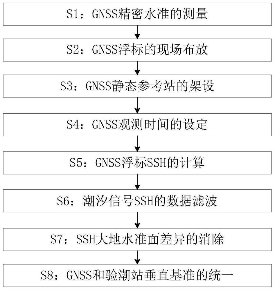
[0033] Such as Figure 1 to Figure 3 As shown, the vertical reference detection method of the tide gauge station utilizing the GNSS buoy described in the present invention comprises the following steps:

[0034] S1: GNSS precision level measurement: determine the height of the GNSS buoy antenna through precise measurement in the laboratory, and determine the height h1 from the phase center of the GNSS buoy antenna to the still water surface;

[0035] S2: On-site deployment of GNSS buoys: including the following small steps:

[0036] S21: GNSS buoys are deployed in the open sea near the marine station;

[0037] S22: The GNSS buoy is connected through a nearby fixed floating ball, so that its horizontal position does not change greatly;

[0038] S23: the sampling frequency of the GNSS buoy is set to 1 Hz;

[0039] S3: GNSS static reference station erection: GNSS static reference station is erected in the land area of ​​the marine station for differential post-processing of GN...

Embodiment 2

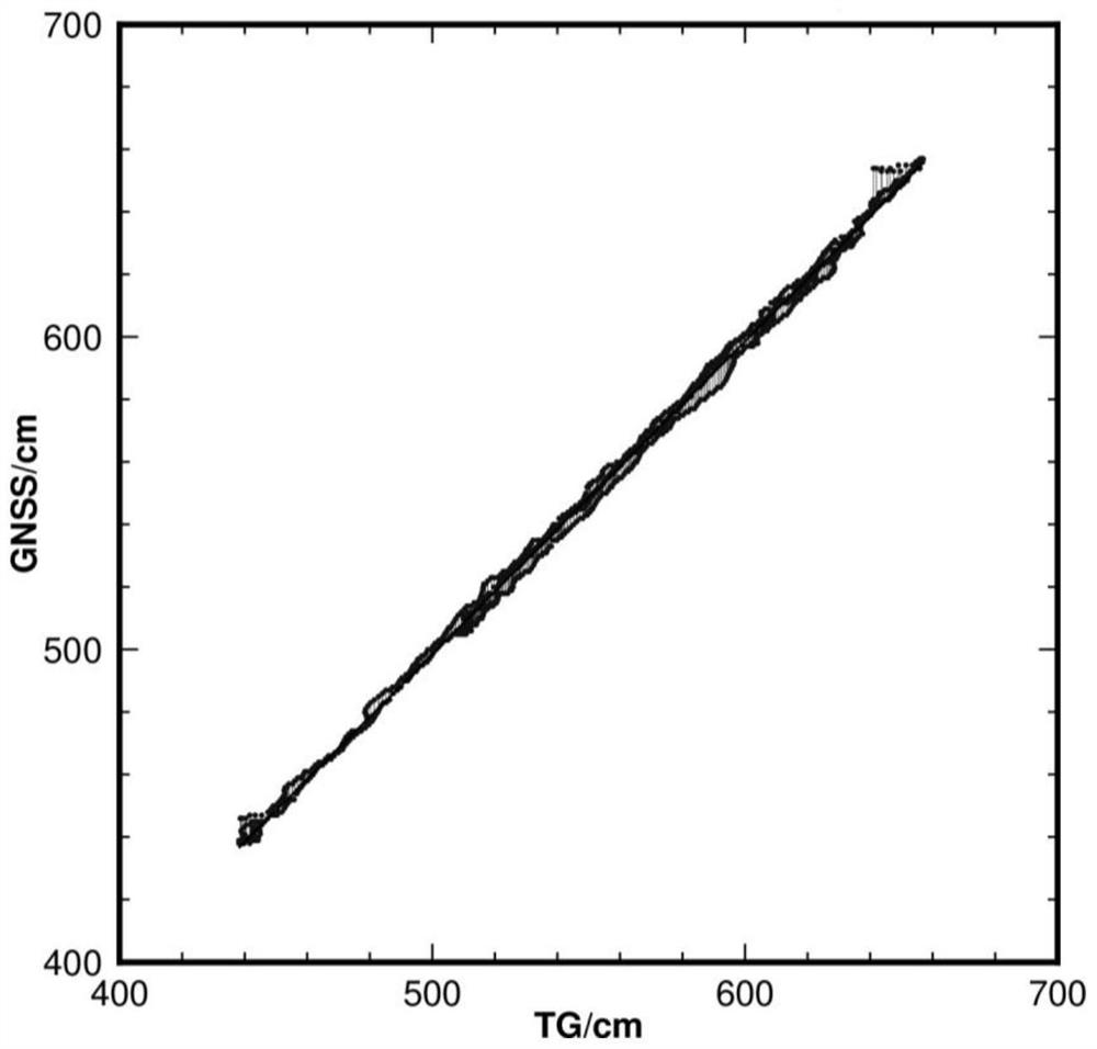
[0056] Take the sea experiment with unified measurement datum at a marine station along the coast of Shandong as an example.

[0057] Assume that a GNSS altimetry buoy is deployed in the open sea area outside the ocean station to observe data for more than 1 day, and the SSH of the GNSS buoy is obtained by the PPK method, and then the geoid difference is corrected, the data is filtered, and the filtered GNSS sea surface By making difference between the height data and the data of the tide gauge station, the difference between the elevation datum of the tide gauge station and the elevation datum of the WGS-84 reference ellipsoid is 54cm, and the slope obtained by the regression analysis is equal to 1.0, where figure 2 For the unified tide gauge and GNSS sea level height, image 3 is the regression analysis result of the unified GNSS and tide gauge sea surface height.

[0058] It should be noted that the unification of the datum of the ocean station tide gauge system is an imp...


PUM


Abstract

The invention relates to a vertical reference detection method of a tide gauge station by using a GNSS buoy, and belongs to the technical field of vertical reference detection of a tide gauge station. The present invention includes the following steps: S1: GNSS precision level measurement, S2: on-site deployment of GNSS buoys, S3: erection of GNSS static reference stations, S4: setting of GNSS observation time, S5: calculation of GNSS buoy SSH, S6 : Data filtering of tide signal SSH, S7: Elimination of SSH geoid difference, S8: Unification of GNSS and vertical datum of tide gauge station. The present invention uses high-precision GNSS altimetry buoys to observe the sea surface height information under the WGS-84 reference ellipsoid datum, avoids the above three problems, conveniently and economically deploys in sea areas near marine stations, and avoids reference displacement errors and levels of tide gauge stations Measurement errors are accumulated, and tide gauge station benchmarks are unified in any sea area (including) remote sea islands and reefs.

Description

technical field [0001] The invention relates to a vertical reference detection method of a tide gauge station by using a GNSS buoy, and belongs to the technical field of vertical reference detection of a tide gauge station. Background technique [0002] At present, the detection of the survey datum of the tide gauge station mainly relies on the GNSS continuous leveling survey, that is, the elevation relationship is established between the GNSS base station and the datum point of the tide gauge station through GNSS precision leveling, so as to obtain the datum point elevation system of the tide gauge station and the WGS of GNSS The system height difference between the -84 reference ellipsoids makes all the tide gauge station datums in my country's coastal areas be reduced to the mathematical reference ellipsoids in the geometric sense, which in turn makes the absolute sea level change and the vertical datum of marine geodesy in a unified and strict To avoid the so-called gaps c...

Claims


Application Information

Patent Timeline
Patent Type & Authority Patents(China)
IPC IPC(8): G01S19/13
CPCG01S19/13
Inventor 杨磊
Owner THE FIRST INST OF OCEANOGRAPHY SOA
Why Eureka
Try Eureka