
Method for quickly splicing aerial images of unmanned aerial vehicle in emergency rescue activities

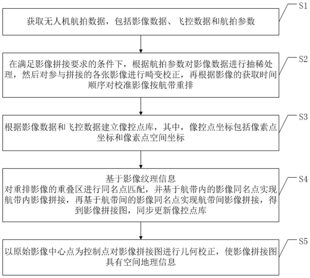
An emergency rescue and image technology, which is applied in the field of rapid stitching of drone aerial images, can solve the problems of high hardware and software requirements, long time, and long production cycle, so as to reduce the difficulty of stitching, reduce the overlap of images, and reduce coordination problem effect

Pending Publication Date: 2021-02-05
AEROSPACE INFORMATION RES INST CAS +1
View PDF0 Cites 6 Cited by
  • Summary
  • Abstract
  • Description
  • Claims
  • Application Information

AI Technical Summary

Problems solved by technology

To ensure the accuracy of data results, all links from raw data acquisition to data processing have strict specification requirements and technical restrictions. , planning, etc.) required basic geographic information products, but the production of such products has high requirements for hardware and software equipment, and the production cycle is long. In conventional flight practice, the data is processed on the corresponding software and hardware platform in the rear after data acquisition. , the processing time varies, but for emergency rescue on-site activities, the time is too long to meet the on-site requirements, so it is mostly used for later disaster assessment, or other scenarios that do not require high data current status
[0005] There are many types of splicing of UAV aerial image data in the existing technology. To sum up, these technologies are either not separated from the general aerial data processing flow or algorithm, or for specific purposes, or based on specific software and hardware, or just solve the splicing process. However, how to fully consider the special needs of emergency rescue scenes, through effective planning and realize the rapid stitching of UAV aerial images And the splicing process with a certain precision is still an important technology development topic

Method used


Image

  • Method for quickly splicing aerial images of unmanned aerial vehicle in emergency rescue activities
  • Method for quickly splicing aerial images of unmanned aerial vehicle in emergency rescue activities
  • Method for quickly splicing aerial images of unmanned aerial vehicle in emergency rescue activities

Examples


Embodiment Construction

[0072] The specific implementation manners of the embodiments of the present invention will be described in detail below in conjunction with the accompanying drawings. It should be understood that the specific implementation manners described here are only used to illustrate and explain the embodiments of the present invention, and are not intended to limit the embodiments of the present invention.

[0073] UAV aerial image stitching actually mainly solves the problems of distortion, deformation and scaling of images in three-dimensional space due to problems such as changes in flight height and flight attitude during aerial photography. When these effects are corrected, theoretically two points with the same name can be realized. The stitching of two images, but in fact these effects cannot be completely eliminated, and can only be overcome or weakened as much as possible so that the effects are within the accuracy requirements of the stitching product. Generally, the flight ...


PUM


Abstract

The invention relates to the field of image splicing and particularly relates to a method for quickly splicing aerial images of an unmanned aerial vehicle in emergency rescue activities. The method comprises the following steps of acquiring aerial data of the unmanned aerial vehicle; thinning the number of the images, and then performing distortion correction and image rearrangement on each imageparticipating in splicing; air strip image splicing being carried out based on the image texture, and then air strip splicing being carried out; and finally, geometrically correcting the spliced imageby taking the central point of the original image as a control point so that the image has geographic space information. According to the method, by reducing the image data and simplifying the data processing process, image splicing can be rapidly carried out, meanwhile, the image data has measurability, splicing efficiency of aerial images of the unmanned aerial vehicle is greatly improved, andthe obtained image splicing image can meet the requirement for emergency rescue command in precision.

Description

technical field [0001] The invention relates to the field of image splicing, in particular to a method for fast splicing of unmanned aerial vehicle images in emergency rescue activities. Background technique [0002] In emergency rescue, such as forest fires, floods, earthquakes and other natural disasters, quick understanding and mastery of ground conditions is an important task before rescue activities, and is also an important source of information for disaster development and disaster status assessment during rescue activities , which has a huge information support function for scientific and orderly rescue dispatching activities. Because of its flexible maneuverability, convenient operation and many other advantages, UAVs can be widely used in emergency rescue activities to carry out on-site disaster information acquisition and real-time monitoring of disasters. [0003] The most important type of disaster information obtained by drones is the ground image data of the ...

Claims


Application Information

Patent Timeline
IPC IPC(8): G06T3/40G06T5/00G06K9/46G01C11/08G01C11/04
CPCG06T3/4038G01C11/08G01C11/04G06V10/462G06T5/80
Inventor 李儒朱海涛陈正超潘洁邓飚陈凯王晓巍徐进勇朱金彪杨宏
Owner AEROSPACE INFORMATION RES INST CAS
Learn More