A field geographic information surveying and mapping equipment and its surveying method

A technology of geographic information and equipment, applied in the direction of measuring instruments, measuring devices, mechanical equipment, etc., can solve problems such as reducing adjustment efficiency, being in a tilted state, and uneven ground, so as to improve leveling efficiency, facilitate adjustment direction, and reduce The effect of labor intensity

Active Publication Date: 2021-11-12
敦少杰
View PDF17 Cites 0 Cited by
  • Summary
  • Abstract
  • Description
  • Claims
  • Application Information

AI Technical Summary

Problems solved by technology

[0003] When using the surveying and mapping equipment to survey and map the geographical information of the field, the operator supports the three surveying and mapping supports on the field, and then adjusts the position of each surveying and mapping support relative to the supporting platform to ensure that the supporting platform is in a flat state, that is, to ensure that the supporting platform is The platform is parallel to the ground surface. If the supporting platform is not flat, the lens of the surveying and mapping instrument will be tilted, thereby reducing the measurement accuracy of the surveying and mapping instrument. When the supporting platform is adjusted in place, the field can be surveyed and mapped by the surveying and mapping instrument
However, although this kind of surveying and mapping equipment can complete the surveying and mapping of the geographical information of the field, the ground in the field is uneven, so that it takes a long time for the operator to adjust the support platform to a horizontal state, which not only increases the labor intensity of the workers , but also reduces the adjustment efficiency
In addition, the existing surveying and mapping equipment also has the following defects: 1. The surveying and mapping angle of the surveying and mapping instrument lens cannot be adjusted at all, and the entire surveying and mapping equipment needs to be moved multiple times to complete the surveying and mapping of the geographic information of the entire field
2. When it is necessary to adjust the height of the surveying and mapping instrument, it is necessary to move closer to or unfold three surveying and mapping supports to complete the adjustment of the height of the surveying and mapping instrument, which is very inconvenient
3. Since the surveying and mapping instrument is fixed on the support platform, the pitch angle of the surveying and mapping instrument cannot be adjusted, so the geographical information of the high and low areas cannot be surveyed and mapped

Method used


Image

  • A field geographic information surveying and mapping equipment and its surveying method
  • A field geographic information surveying and mapping equipment and its surveying method
  • A field geographic information surveying and mapping equipment and its surveying method

Examples


Embodiment Construction

[0035] The present invention will be further described below in conjunction with accompanying drawing, protection scope of the present invention is not limited to the following:

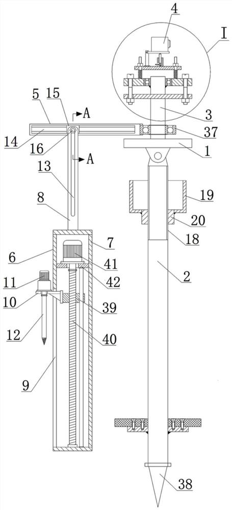
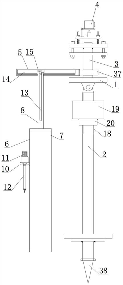
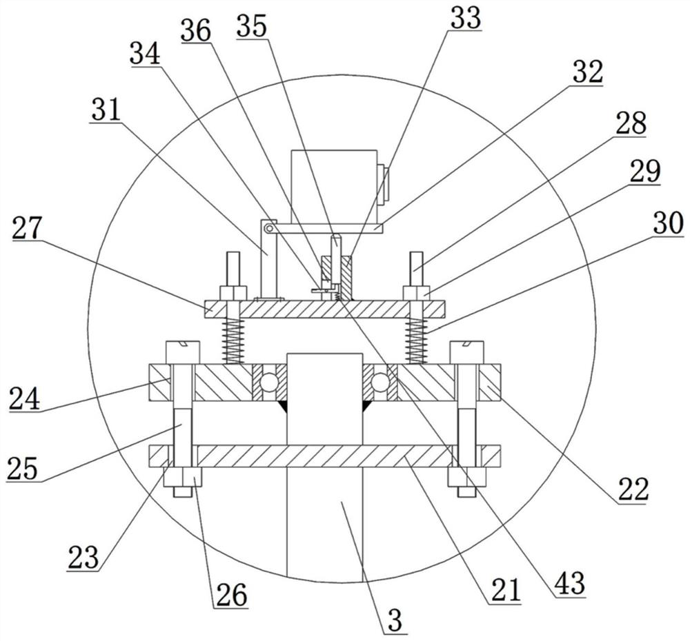
[0036] Such as Figure 1-8 As shown, a field geographic information surveying and mapping equipment includes a support platform 1, a main shaft 2 hinged at the bottom of the support platform 1, a surveying and mapping instrument adjustment mechanism fixed on the top of the support platform 1, and a pointed head 38 is fixed at the bottom of the main shaft 2 , the surveying instrument adjustment mechanism includes a fixed shaft 3, a height adjustment mechanism for adjusting the height of the surveying instrument, a direction adjustment mechanism for adjusting the surveying direction of the surveying instrument, and a pitch adjustment mechanism for adjusting the surveying angle of the surveying instrument. The shaft 3 is fixed on the direction adjustment mechanism, the height adjustment mechanism is arr...


PUM


Abstract

The invention discloses a field geographic information surveying and mapping equipment, which comprises a support platform, a main shaft hinged at the bottom of the support platform, and a surveying and mapping instrument adjustment mechanism fixed on the top of the support platform. The surveying and mapping instrument adjustment mechanism includes a fixed shaft for adjusting The height adjustment mechanism for the height of the surveying and mapping instrument, the direction adjustment mechanism for adjusting the surveying direction of the surveying and mapping instrument, and the pitch adjustment mechanism for adjusting the surveying and mapping angle of the surveying and mapping instrument, the fixed shaft is fixed on the direction adjustment mechanism, and the height adjustment mechanism is set on the direction adjustment mechanism , the pitch adjustment mechanism is set on the height adjustment mechanism, and the surveying and mapping instrument is set on the pitch adjustment mechanism. The beneficial effects of the present invention are: the support platform can be quickly and efficiently leveled, the surveying direction of the surveying and mapping instrument can be adjusted arbitrarily, the height of the surveying and mapping instrument can be adjusted conveniently, the pitch angle of the surveying and mapping instrument can be adjusted, and it can adapt to uneven ground.

Description

technical field [0001] The invention relates to the technical field of surveying and mapping equipment, in particular to a field geographic information surveying and mapping equipment and a measuring method thereof. Background technique [0002] Surveying and mapping equipment refers to instruments and devices such as data acquisition, processing, and output designed and manufactured for surveying and mapping operations, and various orientation, distance measurement, angle measurement, Instruments for height measurement, mapping and photogrammetry. The current surveying and mapping equipment includes a supporting platform, a surveying and mapping instrument and a surveying and mapping bracket. The bottom of the supporting platform is hinged with three surveying and mapping supports in its circumferential direction. The surveying and mapping instrument is fixedly installed on the top of the supporting platform. For geographic information, the operator can deploy and support ...

Claims


Application Information

Patent Timeline
Patent Type & Authority Patents(China)
IPC IPC(8): F16M11/04F16M11/12F16M11/16F16M11/18F16M11/20F16M11/24G01C15/00
CPCF16M11/046F16M11/121F16M11/16F16M11/18F16M11/2014F16M11/2085F16M11/24F16M2200/068F16M2200/08G01C15/00
Inventor 敦少杰
Owner 敦少杰
Why Eureka
Try Eureka