
Remote sensing-based riverway water volume estimation method

A water volume and river channel technology, applied in the field of river channel water volume estimation based on remote sensing, can solve the problems of not being provided for free, difficult to use river water volume, limited layout of hydrological stations, etc., and achieve the effect of convenient flood control work.

Active Publication Date: 2020-06-02
HOHAI UNIV
View PDF4 Cites 2 Cited by
  • Summary
  • Abstract
  • Description
  • Claims
  • Application Information

AI Technical Summary

Problems solved by technology

Usually, river water flow data can be obtained through hydrometric stations, but the layout of hydrometric stations is limited and not free, which brings great difficulties to the utilization of river water

Method used


Image

  • Remote sensing-based riverway water volume estimation method
  • Remote sensing-based riverway water volume estimation method
  • Remote sensing-based riverway water volume estimation method

Examples


Embodiment Construction

[0028] The present invention will be further explained below in conjunction with the accompanying drawings and specific embodiments.

[0029] In the present embodiment, the inventive method is applied to the Qinhuai River Basin, and its specific steps are as follows:

[0030] S1: Get watershed boundaries

[0031] Download the DEM data of the Qinhuai River Basin from the geospatial data cloud, use ArcGIS to extract the valley line and ridge line, and then outline the area where the valley line is located with the ridge line, and use the vector data processing method to obtain the shp file of the border of the Qinhuai River Basin.

[0032] S2: Obtain remote sensing data images

[0033] Download the Landsat-8 or Landsat-7 remote sensing data images covering the Qinhuai River Basin. Considering the annual distribution of the Qinhuai River's water flow, and the fact that the river freezes and ice packs in winter and spring are not conducive to research, choose 2007-2016 From June...


PUM


Abstract

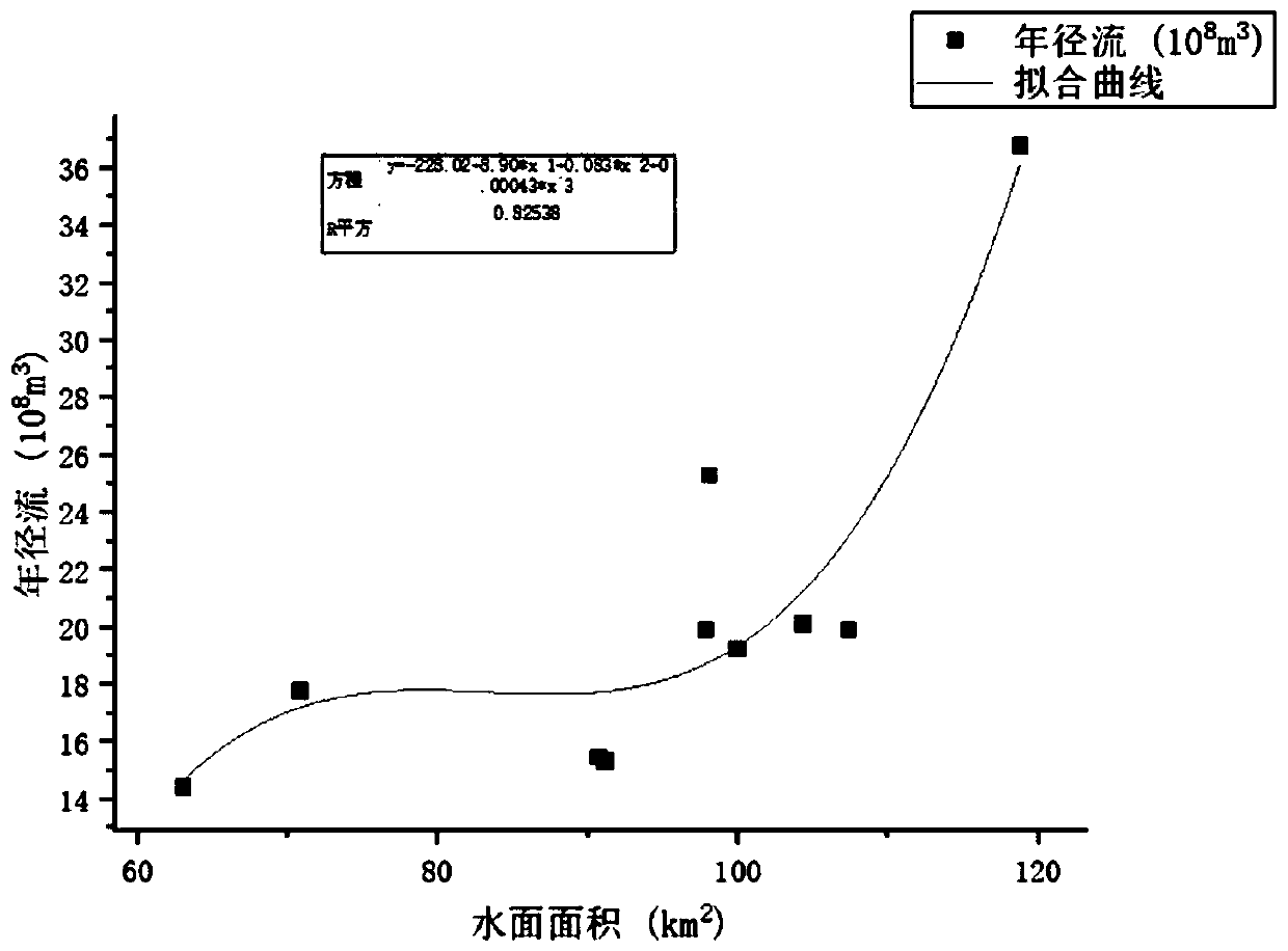
The invention discloses a remote sensing-based riverway water volume estimation method. The method comprises the following steps of obtaining a drainage basin boundary; acquiring a drainage basin remote sensing data image; cutting the drainage basin remote sensing data image: cutting the remote sensing data image in the step S2 by using the drainage basin boundary obtained in the step S1 in ENVI software to obtain the remote sensing data image of the whole drainage basin; extracting a basin water surface area; obtaining basin water volume data; and establishing a watershed water surface annualrunoff relationship: drawing a watershed water surface area and watershed water volume curve of the corresponding year, performing fitting to obtain a watershed runoff estimation formula and a correlation coefficient, and obtaining a river water volume estimation result through the watershed runoff estimation formula. According to the method, the water volume change of the river can be timely andquickly obtained, the problems of insufficient basin hydrological data and the like can be effectively solved, the dependence on actual measurement data is reduced, and the method has relatively goodprecision and extrapolation applicability.

Description

technical field [0001] The invention belongs to the technical field of water conservancy engineering, and in particular relates to a method for estimating river water volume based on remote sensing. Background technique [0002] River flow calculation is widely used in water resources planning, flood prevention, water conservancy project planning and other fields. Usually, river water flow data can be obtained through hydrometric stations, but the layout of hydrometric stations is limited and not provided for free, which brings great difficulties to the utilization of river water. [0003] Therefore, a new technical solution is needed to solve this problem. Contents of the invention [0004] Purpose of the invention: In order to overcome the deficiencies in the prior art, provide a method for estimating river water volume based on remote sensing. This method obtains remote sensing images of a certain year in the river basin, and uses ENVI to supervise and classify the wat...

Claims


Application Information

Patent Timeline
IPC IPC(8): G06Q10/04G06T7/62G06T7/13
CPCG06Q10/04G06T7/62G06T7/13G06T2207/10032G06T2207/30181Y02A10/40
Inventor 董增川张璐徐伟金大伟任杰王诗韵贾晴雯
Owner HOHAI UNIV
Learn More