Unmanned aerial vehicle side slope and foundation pit excavation amount measuring device

An unmanned aerial vehicle and slope technology, applied in the field of earth and stone engineering, can solve the problems of large errors and limited accuracy of three-dimensional digital models, and achieve accurate slope measurement, overcome limitations, and reduce operating costs and labor intensity. Effect

Inactive Publication Date: 2020-05-29
王刚强
View PDF0 Cites 8 Cited by
  • Summary
  • Abstract
  • Description
  • Claims
  • Application Information

AI Technical Summary

Problems solved by technology

[0005] The purpose of the present invention is to solve the problems of low accuracy, traditional single-point measurement method, point-to-surface, and error and relatively large limitations in establishing a three-dimensional digital model, and proposes a drone for measuring slopes and foundation pits mining equipment

Method used


Image

  • Unmanned aerial vehicle side slope and foundation pit excavation amount measuring device
  • Unmanned aerial vehicle side slope and foundation pit excavation amount measuring device
  • Unmanned aerial vehicle side slope and foundation pit excavation amount measuring device

Examples


Embodiment 1

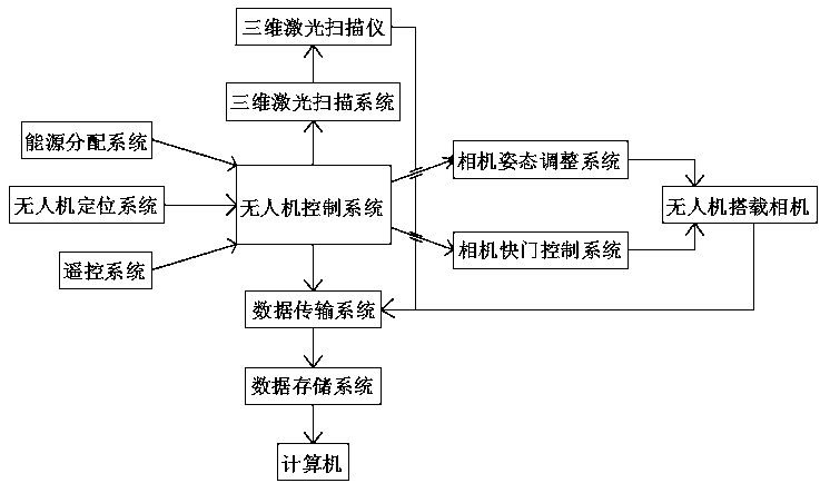
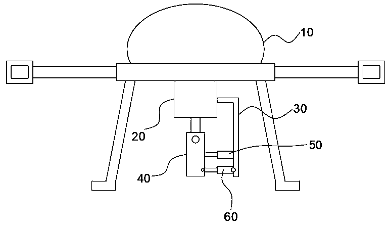
[0033] refer to Figure 1-3 , an unmanned aerial vehicle for measuring the excavation volume of slopes and foundation pits, including an unmanned aerial vehicle body 10, and also includes:

[0034] The flight control system maintains the drone's flight stability and receives and responds to wireless transmission instructions and completes corresponding operations;

[0035] The UAV positioning system receives satellite signals and provides the location and orientation information of the UAV to the flight control system;

[0036] The unmanned aerial vehicle is equipped with a camera 40, which is mounted on the unmanned aerial vehicle frame and performs multi-frequency photographing and storage of the slope area;

[0037] The 3D laser scanning system, which is connected with the UAV control system, can provide 3D point cloud data for scanning the surface of the slope area, and store the 3D point cloud data. The 3D laser scanning system is a 3D laser scanner, and the 3D laser sca...

Embodiment 2

[0059] refer to Figure 4 , the camera attitude adjustment system includes a mounting rod 120 arranged on the lower end of the drone body 10 through a ball end joint bearing. There are a plurality of adjustment devices evenly distributed in the circumferential direction of the center of the circle, and the adjustment devices include a fixed plate 140 and an electric reel 130 symmetrically fixed on the lower end of the drone body 10 about the mounting rod 120, and an automatic reset reel 150 is installed on the fixed plate 140. Resetting reel 150 realizes automatic reset for the cooperating setting of reel and torsion spring, improves the stability of installation rod 120, and electric reel 130 and automatic reset reel 150 are all wound with traction rope, and traction rope The other end is fixedly connected with the mounting rod 120.

[0060] The ball joint rod end joint bearing includes a spherical joint head 100, a bowl-shaped joint socket 110 and a jelly mucus filled there...


PUM


Abstract

The invention discloses an unmanned aerial vehicle side slope and foundation pit excavation amount measuring device which comprises an unmanned aerial vehicle body and further comprises a flight control system for maintaining flight stability of an unmanned aerial vehicle, receiving an instruction responding to wireless transmission and completing corresponding operation. The device has the advantages that the important premise of calculating the earthwork volume is achieved by conducting three-dimensional modeling and visual expression on a slope area to be measured, A flexible low-altitude unmanned aerial vehicle carries a digital camera to obtain a slope sequence image, a dense three-dimensional point cloud of the slope body is generated according to a computer vision principle, and themanufacturing of the three-dimensional digital model of the slope body is realized. According to the technology, the side slope fine terrain can be quickly constructed, the operation cost and the labor intensity are effectively reduced, the limitation that a traditional single-point measurement mode is used for bringing surfaces point by point is overcome, the generated three-dimensional model can comprehensively express the overall shape and local detail characteristics of the slope, slope measurement is more accurate, and the earthwork filling and digging position and the earthwork volume can be perfectly solved.

Description

technical field [0001] The invention relates to the technical field of earthwork engineering, in particular to a device for measuring the excavation volume of slopes and foundation pits by unmanned aerial vehicles. Background technique [0002] There are high or low slopes and their side slopes everywhere on the surface of the earth. In civil engineering projects, we often encounter problems such as excavation of road cuttings, leveling of large sites, excavation of foundation pits for side slope treatment, etc., which require Determine the amount of soil to be filled and excavated on the slope. The calculation of earthwork is an important step in engineering construction. It is an important factor in project cost estimation and scheme optimization, and is also an important part of engineering design, which is directly related to project cost. [0003] In the current slope earthwork calculation, traditional manual calculation methods such as section method, or calculation b...

Claims


Application Information

Patent Timeline
IPC IPC(8): G01C11/02G01B11/24
CPCG01B11/24G01C11/025
Inventor 王刚强
Owner 王刚强
Why Eureka
Try Eureka