Atmospheric radon correction method for aviation radioactivity spectrum data
A technique of atmospheric radon and spectral data, applied in the field of airborne geophysical exploration
- Summary
- Abstract
- Description
- Claims
- Application Information
AI Technical Summary
Problems solved by technology
Method used
Image
Examples
Embodiment Construction
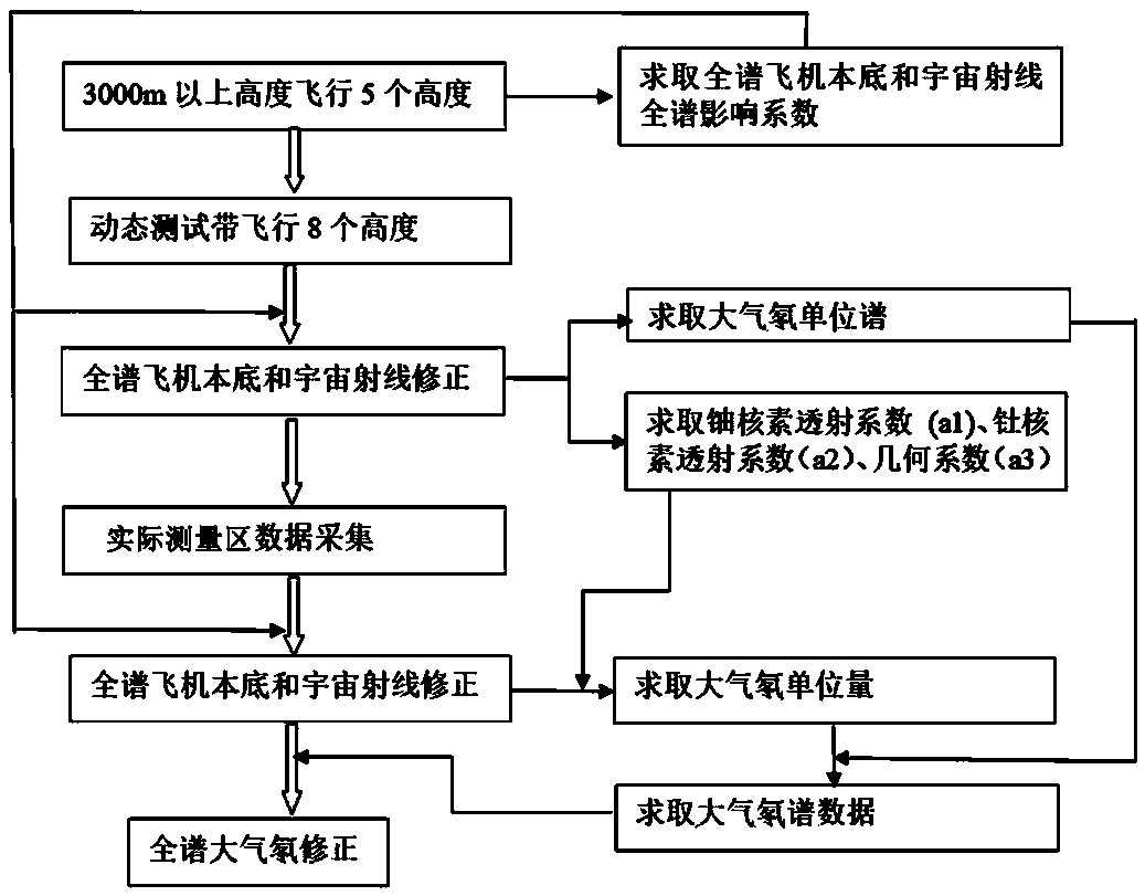
[0025] Such as figure 1 Shown, the present invention comprises the following steps:
[0026] a. Fly at least two different altitudes at an altitude of 3000m and above in the test zone, and collect cosmic ray data at different heights in the test zone;
[0027] b. According to the cosmic ray data collected in the step a, calculate the test band full-spectrum aircraft background and cosmic ray full-spectrum influence coefficient;
[0028] c. Fly in a dynamic test zone with water surface and land, fly at multiple altitudes below 300m, and collect data of atmospheric radon at different altitudes;
[0029] d. According to the data of atmospheric radon at different heights in the test zone collected in step c, the full-spectrum aircraft background and cosmic ray full-spectrum influence coefficient of the test zone are corrected;
[0030] e. After correcting the full-spectrum aircraft background and cosmic ray full-spectrum influence coefficients in the test zone, obtain the atmosp...
PUM
 Abstract
Description
Claims
Application Information
 - Generate Ideas
- Intellectual Property
- Life Sciences
- Materials
- Tech Scout
- Unparalleled Data Quality
- Higher Quality Content
- 60% Fewer Hallucinations
Browse by: Latest US Patents, China's latest patents, Technical Efficacy Thesaurus, Application Domain, Technology Topic, Popular Technical Reports.
© 2025 PatSnap. All rights reserved.Legal|Privacy policy|Modern Slavery Act Transparency Statement|Sitemap|About US| Contact US: help@patsnap.com


