Method for constructing three-dimensional flight path planning space

A track planning and construction method technology, applied in the information field, can solve the problems of large map resolution, large amount of calculation, and inaccurate planning path, and achieve the effect of solving large amount of calculation, low amount of calculation, and reasonable path

Inactive Publication Date: 2020-02-28
NORTHWESTERN POLYTECHNICAL UNIV
View PDF5 Cites 5 Cited by
  • Summary
  • Abstract
  • Description
  • Claims
  • Application Information

AI Technical Summary

Problems solved by technology

In the current research, the flight environment (global search space) of the UAV is obtained by modeling. Use; the environment modeling method is to divide the three-dimensional space into n planes according to the main direction of drone flight, and then divide each plane into m×l grids, so that the three-dimensional space is divided into n×m×l Grid, construct n×m×l grid digital map in the O-XYZ coordinate system as the flight environment of the UAV. For the convenience of simulation, some researches divide the number of grids less, generally 20×20×20, If the actual flight area is also divided into 20×20×20 grids, the resolution of the map is too large and the planned path is not accurate enough; The direction is to search the flying nodes of the UAV in the m×l grid of the i-th (i∈[0,n]) plane, search for a node in each plane, and finally find a reasonable path, and calculate The amount is large, and the minimum track constraint of the UAV is not considered

Method used


Image

  • Method for constructing three-dimensional flight path planning space
  • Method for constructing three-dimensional flight path planning space
  • Method for constructing three-dimensional flight path planning space

Examples


Embodiment Construction

[0037] The present invention will be described in detail below in conjunction with the accompanying drawings and specific embodiments.

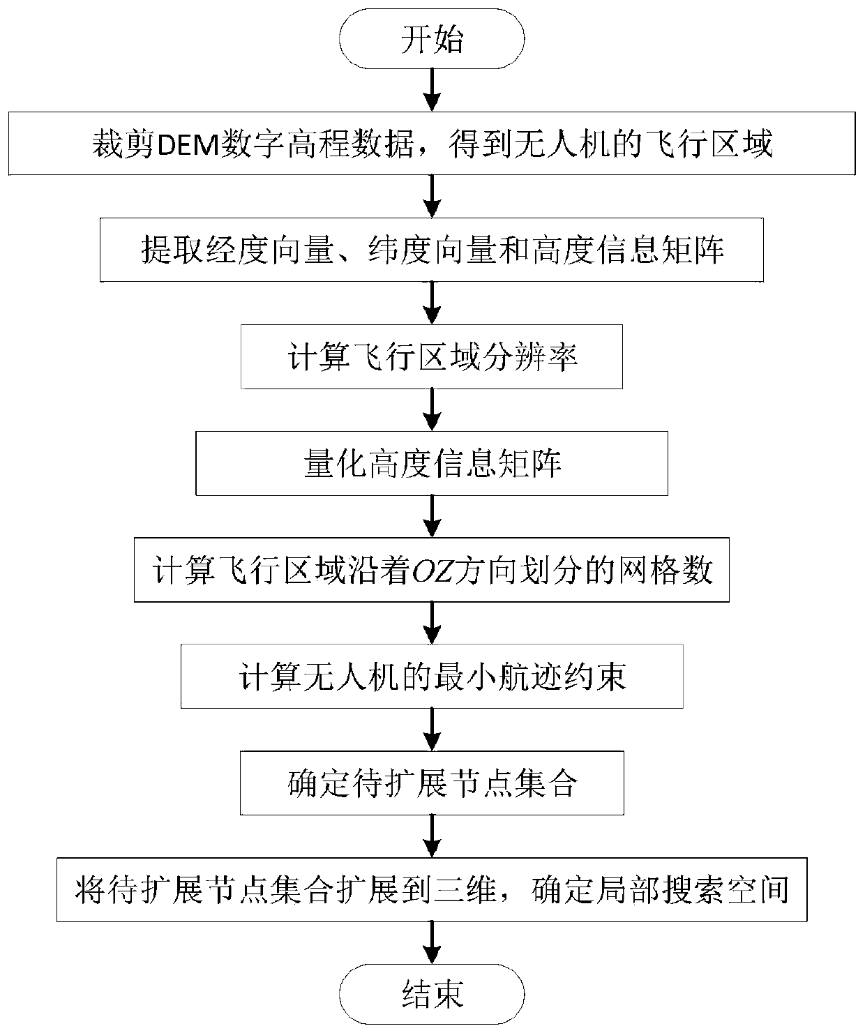
[0038] A method for constructing a three-dimensional track planning space of the present invention, the method for constructing is as follows:

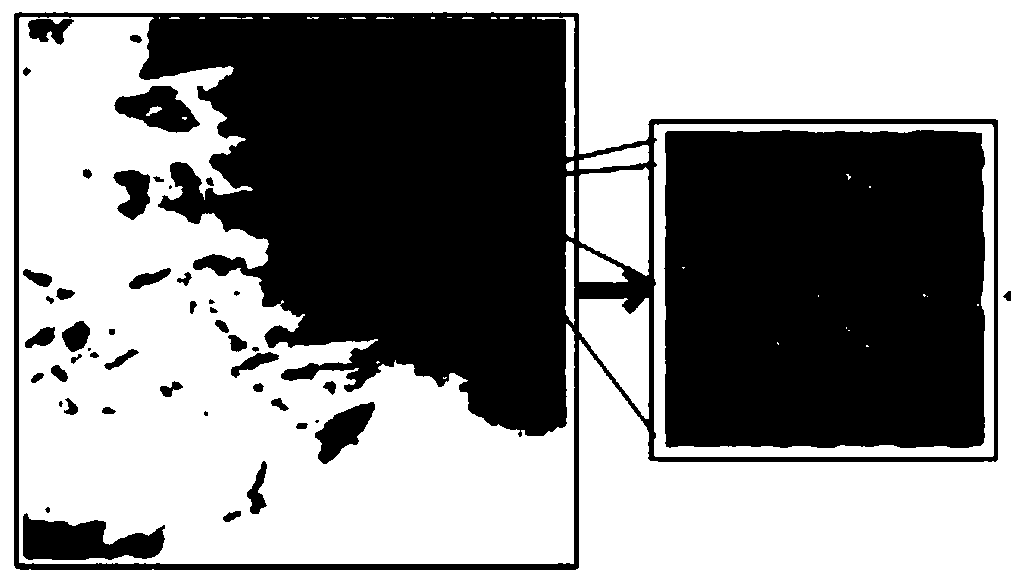
[0039] Step 1. Cut out the actual flight area of ​​the UAV from the original DEM digital elevation data, and export the data in .xyz format; in step 1, use Global Mapper to cut out the actual flight area of ​​the UAV.

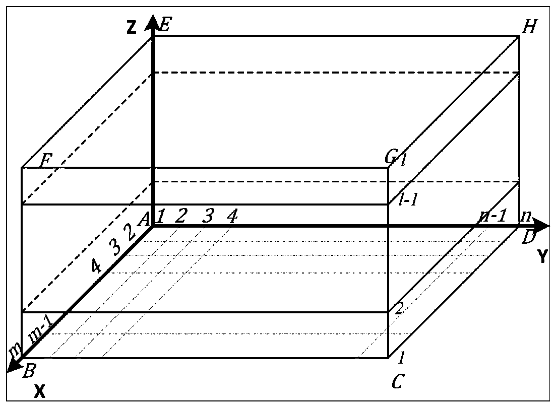
[0040] Step 2. According to the .xyz format data in step 1, the actual flight area of ​​the UAV is divided into n×m×l grids, and the positions of the UAV at different times are located on the nodes of the grid, which constitutes the navigation The global search space for trajectory planning; where: n, m and l are the corresponding equal divisions along the OX, OY and OZ directions in the space coordinate system O-XYZ, respectively, and are all positive integers.

[0041] The specific...


PUM


Abstract

The invention discloses a method for constructing a three-dimensional flight path planning space, and the method comprises the following steps: 1, cutting an actual flight area of an unmanned aerial vehicle from original DEM (Digital Elevation Model) digital elevation data, and exporting data in a. Xyz format; 2, according to the data in the. Xyz format in step 1, dividing the actual flight area of the unmanned aerial vehicle into n*m*1 grids, namely forming a global search space of flight path planning; 3, in the range of the global search space, determining a to-be-extended node set in the XOY plane according to the course, the maximum flight deflection angle constraint and the minimum flight path constraint of the unmanned aerial vehicle, and then extending the to-be-extended node set to three dimensions to construct a local search space of the unmanned aerial vehicle. The construction method is divided into construction of a global search space and construction of a local search space, so the method avoids the defect of large calculated amount caused by layered advancing, and gives consideration to the maximum flight deflection angle and the minimum flight path constraint of unmanned aerial vehicle flight, and enables a planned path to be more reasonable.

Description

【Technical field】 [0001] The invention belongs to the technical field of information technology, and in particular relates to a method for constructing a three-dimensional flight track planning space. 【Background technique】 [0002] In recent years, UAVs have developed rapidly and are widely used in military, commercial, agricultural, performance and other aspects. Considering the safety and survival probability of UAVs, UAVs must choose a path that can reach the target and maximize the possibility. The path to complete the mission and return, so track planning has become a very important content in the research work related to UAV. [0003] The ant colony algorithm was proposed by Marco Dorigo in 1992. Because the algorithm has the characteristics of distributed computing, information positive feedback and heuristic search, it is essentially a heuristic global optimization algorithm in evolutionary algorithms; in recent years, for three-dimensional track To plan the study,...

Claims


Application Information

Patent Timeline
Patent Type & Authority Applications(China)
IPC IPC(8): G01C21/00G01C21/20
CPCG01C21/005G01C21/20
Inventor 魏江王建军王健梅少辉秦春霞
Owner NORTHWESTERN POLYTECHNICAL UNIV
Why Eureka
Try Eureka