A real-time decimeter-level positioning method based on Beidou tri-frequency signals at long distances

A positioning method and decimeter-level technology, applied in the field of global navigation satellite positioning, can solve the problems of timeliness of positioning, difficulty in meeting application requirements, and low accuracy of ranging codes, and achieve the effect of saving construction and maintenance costs

Active Publication Date: 2021-10-15
XIAMEN UNIV OF TECH
View PDF6 Cites 0 Cited by
  • Summary
  • Abstract
  • Description
  • Claims
  • Application Information

AI Technical Summary

Problems solved by technology

For this reason, the problem of high-precision relative positioning under the long-distance environment of a single reference station has always been a hot issue concerned by many scholars in this field
[0003] However, as the distance between the user and the reference station increases, the impact of spatial correlation errors such as atmospheric errors on positioning also increases, and real-time high-precision positioning at long distances still faces certain problems. On the one hand, in terms of pseudo-range positioning, Although the pseudo-range differential positioning does not need to solve the cycle slip and ambiguity, the efficiency is high, and the sub-meter level positioning accuracy can usually be obtained at short distances (<20km), but due to the low accuracy of the ranging code and the influence of spatial correlation errors, the As the distance increases, the positioning accuracy gradually decreases to the meter level or even lower, which is usually difficult to meet the needs of people's daily life applications; Above 80km, it usually takes nearly 10 minutes to obtain high-precision positioning information with fixed ambiguity, and the timeliness of positioning is affected to a certain extent.
Currently, Beidou is the only satellite navigation system in which all satellites broadcast three-frequency signals. The three-frequency signals bring opportunities and challenges to GNSS positioning

Method used


Image

  • A real-time decimeter-level positioning method based on Beidou tri-frequency signals at long distances
  • A real-time decimeter-level positioning method based on Beidou tri-frequency signals at long distances
  • A real-time decimeter-level positioning method based on Beidou tri-frequency signals at long distances

Examples


Embodiment Construction

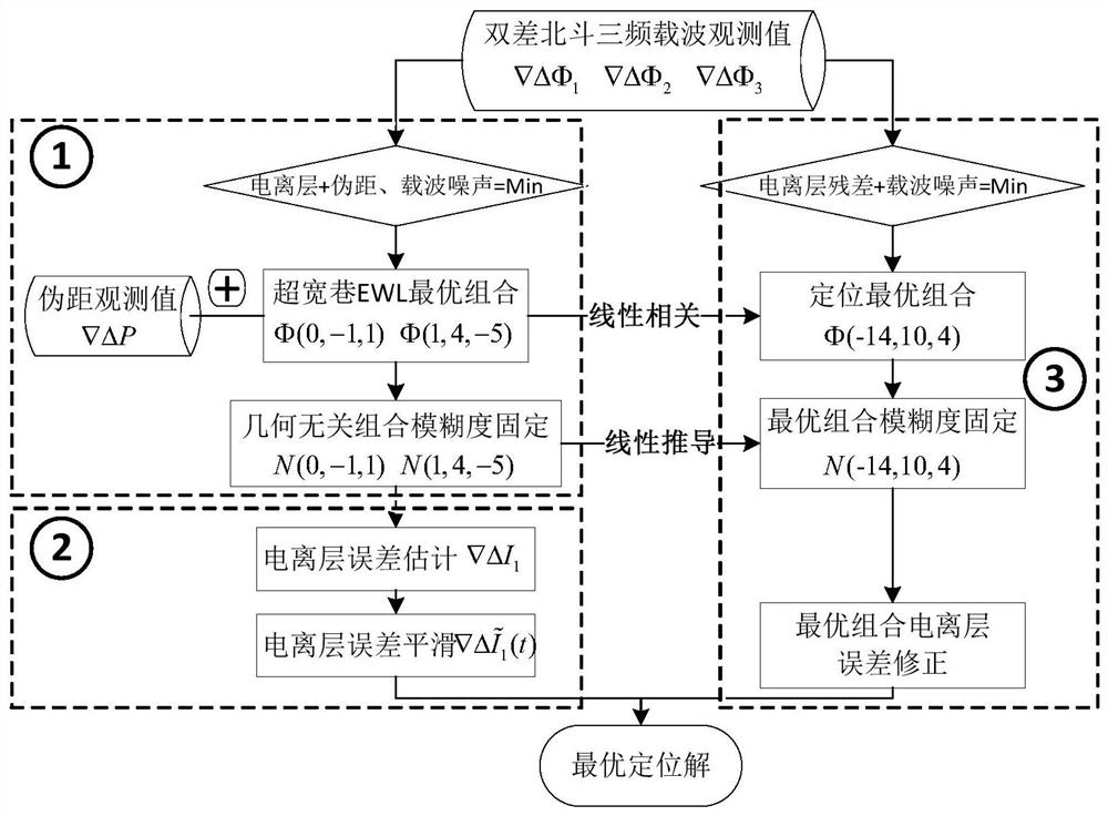
[0055] Such as figure 1 As shown, the present invention provides a real-time decimeter-level positioning method based on Beidou tri-frequency signals at a long distance from a single reference station. Based on the principle of minimum noise impact, the optimal combined observations Φ(0,-1,1) and Φ(1,4,-5) for ultra-wide lane ambiguity resolution are constructed, and the single-epoch fixed correspondence is based on the rounding method Ambiguity Then, the initial value of the ionospheric error is estimated according to the fixed integer ambiguity, and the idea of ​​smoothing is introduced to further optimize the ionospheric error through Hatch filtering. It is to make full use of the linear correlation characteristics of the combined wide-lane observations, and based on the condition that the comprehensive influence of the ionospheric error and the combined observation noise of the carrier wave is the minimum, to construct the optimal wide-lane combined observations Φ(-14,10...


PUM


Abstract

The invention discloses a real-time decimeter-level positioning method based on Beidou tri-frequency signals under long-distance conditions of a single reference station. Based on the principle of minimizing the influence of observation noise, the optimal combination of observations for ultra-wide lane ambiguity resolution is selected, and the ultra-wide lane ambiguity is fixed in a single epoch based on the rounding method; then, the ionosphere is estimated based on the fixed integer ambiguity The initial value of the error is calculated, and the ionospheric error is further optimized by Hatch filtering; finally, based on the condition that the comprehensive influence of the ionospheric error and the carrier combination observation noise is the smallest, the optimal wide-lane combination observation volume with the smallest positioning estimation error is constructed, and the observation volume Perform ionospheric error correction to realize long-distance real-time decimeter-level positioning. This method constructs the optimal combination of observations with the smallest positioning estimation error, and realizes real-time high-precision decimeter-level positioning over long distances.

Description

technical field [0001] The invention belongs to the technical field of global navigation satellite positioning, and in particular relates to a real-time decimeter-level positioning method based on Beidou tri-frequency signals in the long-distance relative positioning mode of a single reference station. Background technique [0002] In the global navigation satellite positioning technology, relative positioning can effectively eliminate or weaken the influence of clock and atmospheric errors, improve the accuracy and timeliness of positioning, and has been widely used in the field of satellite navigation and positioning applications. It is currently realized by using the global satellite navigation system GNSS One of the main technical means of high-precision positioning. Currently, the most representative relative positioning application is the network differential technology (Network RTK) based on the Continuously Operating Reference System (CORS), which can provide real-ti...

Claims


Application Information

Patent Timeline
Patent Type & Authority Patents(China)
IPC IPC(8): G01S19/44
CPCG01S19/44
Inventor 邓健张静何原荣
Owner XIAMEN UNIV OF TECH
Why Eureka
Try Eureka