Method and system for displaying map according to user-defined area for OGC standard

A regional display, custom technology, applied in geographic information database, visual data mining, structured data browsing and other directions, to achieve good promotion and application value, improve application capabilities, and the effect of multiple business scenarios

Active Publication Date: 2019-08-09
INSPUR QILU SOFTWARE IND
View PDF5 Cites 2 Cited by
  • Summary
  • Abstract
  • Description
  • Claims
  • Application Information

AI Technical Summary

Problems solved by technology

With the deepening of business in all walks of life, the ability to display maps only according to the scope of the screen can no longer meet the current needs. For example, gas pipeline data is confidential data, and each gas company can only view the pipeline map within its functional scope. Data and functional areas are generally not a standard rectangle, and the traditional Web map display method can no longer meet this demand

Method used


Image

  • Method and system for displaying map according to user-defined area for OGC standard
  • Method and system for displaying map according to user-defined area for OGC standard
  • Method and system for displaying map according to user-defined area for OGC standard

Examples


Embodiment

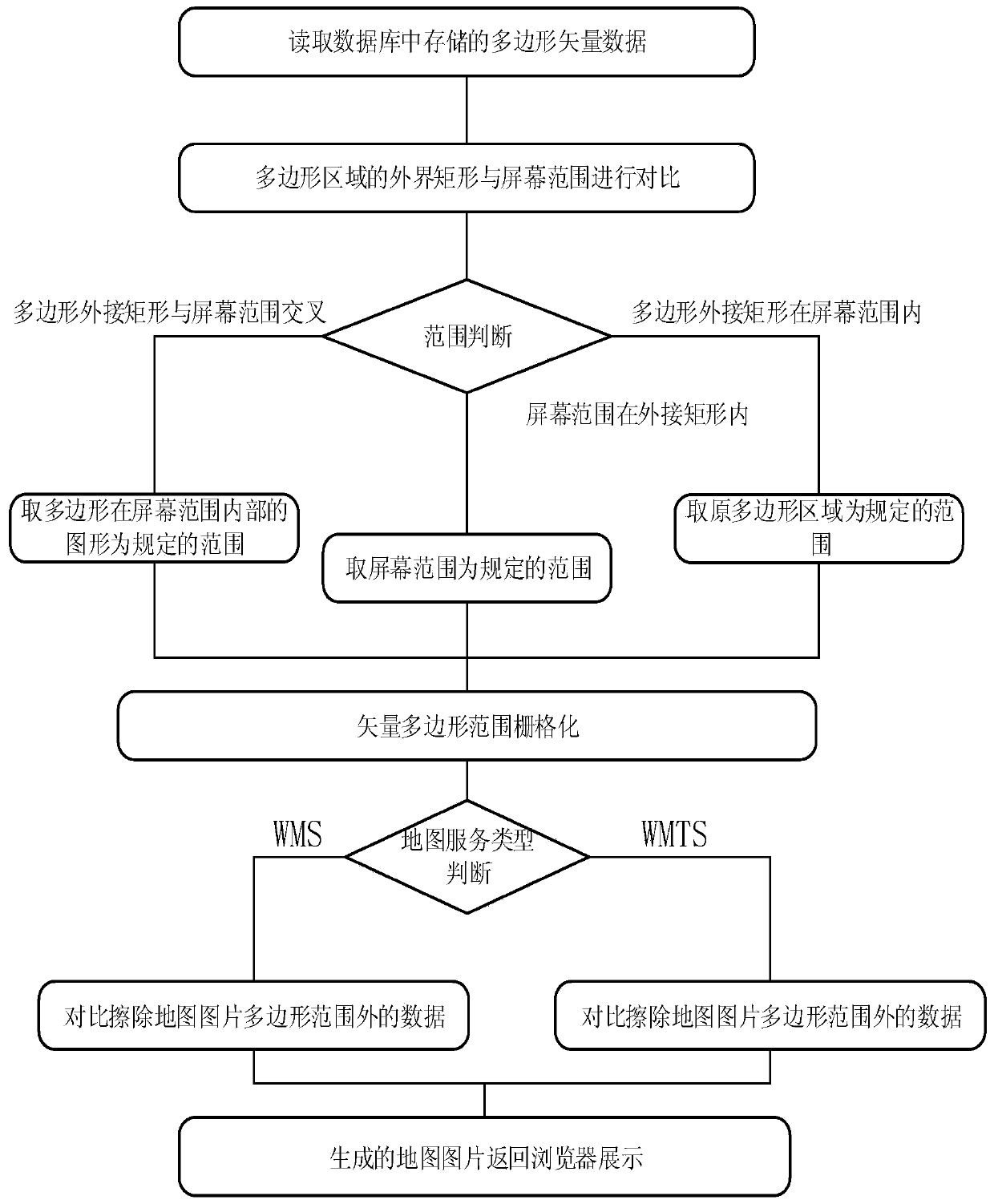
[0038] Such as figure 1 As shown, the OGC standard-oriented method of the present invention for displaying a map in a self-defined area calculates the endpoints that form a polygonal area, completes the rasterization of the polygonal area, erases the map pixels that do not belong to the polygonal area, and controls the map. display range.

[0039] The method specifically includes the following steps:

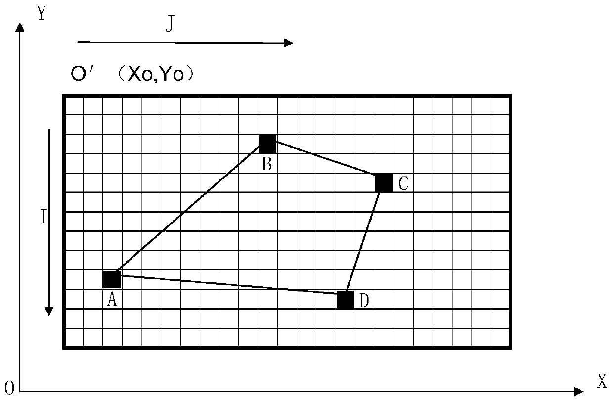
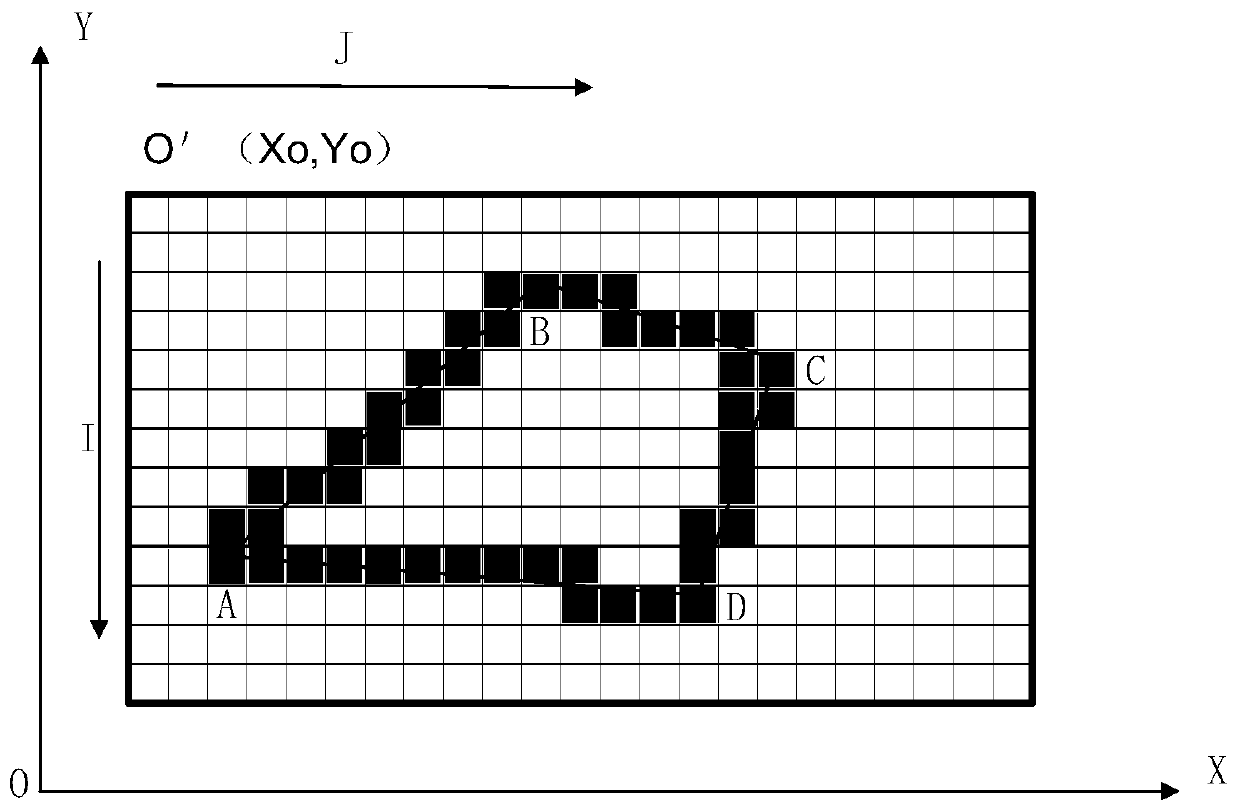
[0040] S1. The endpoint of the polygon is determined.

[0041] Read the polygon vector data in the database, compare the outside of the polygon area with the screen range, and determine the endpoints of the polygon, including the polygon area completely within the screen range, the polygon area intersecting with the screen range, and the screen range within the polygon area.

[0042] S2. Rasterization of polygon endpoints.

[0043] The point coordinates in the vector data corresponding to the polygon endpoints are represented by (X, Y), while in the raster data, they are repr...


PUM


Abstract

The invention discloses a method and a system for displaying a map according to a user-defined area for an OGC standard, and belongs to the technical field of map content display range control. According to the method for displaying the map according to the user-defined area oriented to the OGC standard, endpoints forming the polygonal area in a surrounding mode are calculated, rasterization of the polygonal area is completed, ground image elements which do not belong to the polygonal area are erased, and the display range of the map is controlled. According to the method for displaying the map according to the user-defined area oriented to the OGC standard, the application capacity of map service can be improved to meet more business scenes, meanwhile, display range control is conducted on the map with the control range permission, and good application and popularization value is achieved.

Description

technical field [0001] The invention relates to the technical field of map content display range control, and specifically provides a method and system for displaying a map in a self-defined area oriented to the OGC standard. Background technique [0002] Geographic Information System (GIS) manages geographic space information and database attribute data at the same time. With the development and application of GIS technology, GIS technology is used in more and more industry informatization. WebGIS based on the Internet is a new direction for the development of GIS technology. With the development of information technology in the world, it is also to solve the problems of traditional GIS, and the application of geographic information systems on the Internet and Intranet with its huge potential and advantages. WebGIS has received more and more attention. It can be seen from the current development and research that there is an increasing demand for WebGIS applications in var...

Claims


Application Information

Patent Timeline
Patent Type & Authority Applications(China)
IPC IPC(8): G06F16/29G06F16/26
CPCG06F16/29G06F16/26Y02D10/00
Inventor 张新法李传义崔维康白玉坤王振东
Owner INSPUR QILU SOFTWARE IND
Why Eureka
Try Eureka