
Design method for realizing Hbase database remote sensing big data storage model based on Google S2

A design method and database technology, applied in the field of database management, can solve the problems of waste of bandwidth resources, different formats, types, numbers, and insufficient data management accuracy, and achieve the effect of efficient storage, taking into account scalability, and taking into account data balance.

Active Publication Date: 2019-05-21
WUHAN UNIV
View PDF5 Cites 6 Cited by
  • Summary
  • Abstract
  • Description
  • Claims
  • Application Information

AI Technical Summary

Problems solved by technology

In the traditional remote sensing image database management method based on file management and a mixture of files and relational databases, remote sensing images exist in the form of files, which is not conducive to the management and distribution of image data, and the security of the system is very low.
[0003] At the same time, there are different ways to obtain remote sensing images, and the data formats of remote sensing images are also various. Most remote sensing image management systems based on databases do not have a unified standard for storing various types of data, and their formats, types, and numbers vary. Undoubtedly increase the system development cost and construction cycle
[0004] In the face of the development of massive data, the fine management of remote sensing data management has become particularly important, and the traditional data management method in the form of metadata + image files has become increasingly inapplicable in the face of massive data
The highlighted problems include: the data provision method is too single, and the data management accuracy is not enough; the same data, multiple users need to perform the same preprocessing operation, and cannot be effectively shared; there is a large amount of invalid information in one data transmission, which wastes Bandwidth resources; the same type of satellite data across the satellite system cannot be used on the same layer; the corresponding spatial areas where the information cannot be directly restored after data analysis need to build another database for management

Method used


Image

  • Design method for realizing Hbase database remote sensing big data storage model based on Google S2
  • Design method for realizing Hbase database remote sensing big data storage model based on Google S2
  • Design method for realizing Hbase database remote sensing big data storage model based on Google S2

Examples


Embodiment Construction

[0030] In order to make the object, technical solution and advantages of the present invention clearer, the present invention will be further described in detail below in conjunction with the accompanying drawings and embodiments. It should be understood that the specific embodiments described here are only used to explain the present invention, not to limit the present invention.

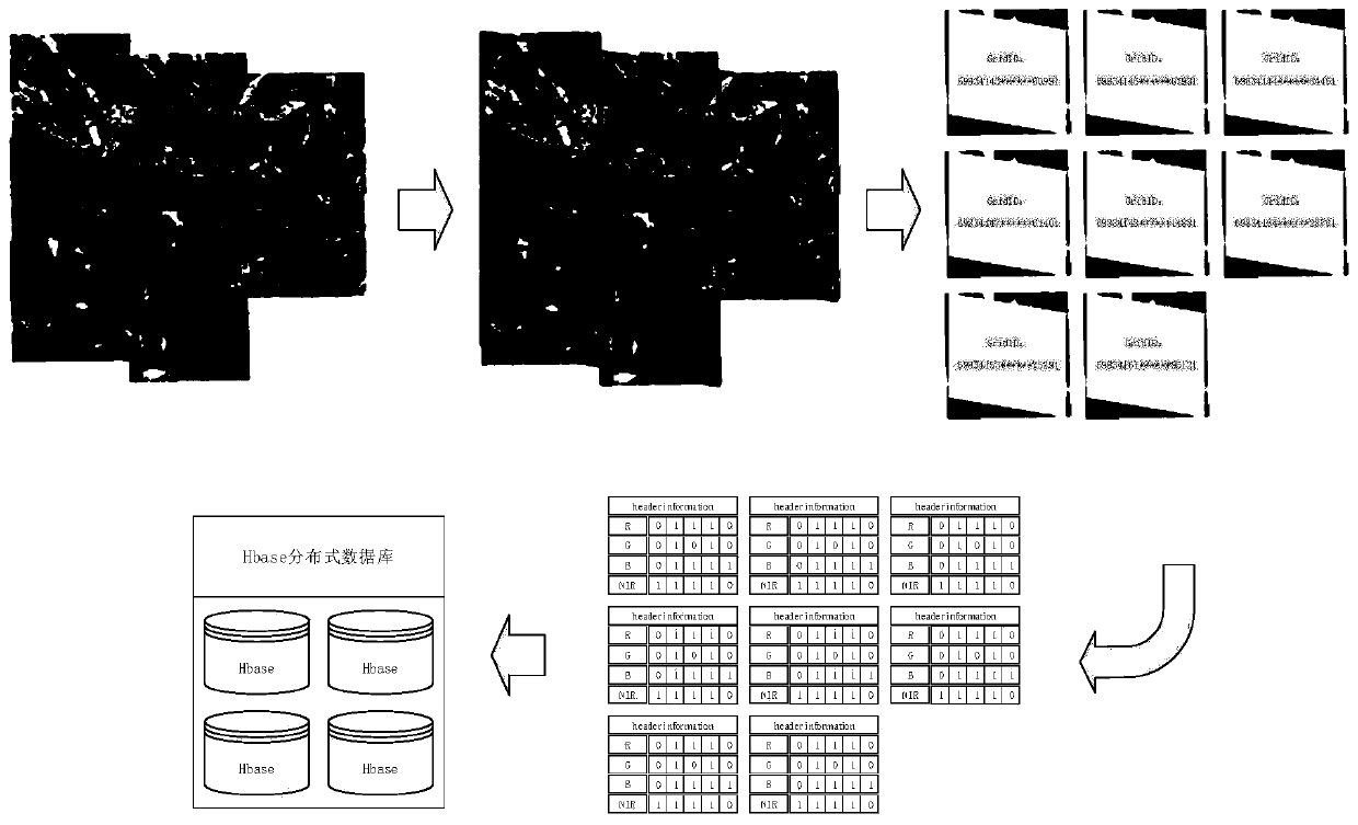
[0031] The embodiment of the present invention based on Google S2 realizes the Hbase database remote sensing large data storage model design method, which is applicable to the image structure composed of spatial description information + multi-layer band matrix, and is a general remote sensing image data storage management method. The specific content includes: the grid cutting of remote sensing data and the establishment of the Hbase database table storage model;

[0032] Grid-based clipping of remote sensing data is used to partition, fragment and ground space discretization of large-scale remote...


PUM


Abstract

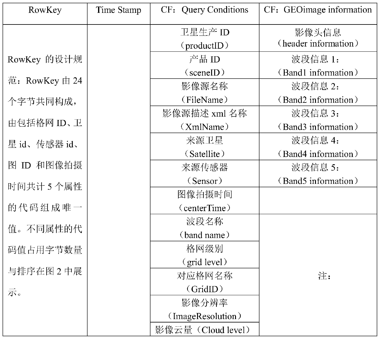
The invention discloses a design method for realizing an Hbase database remote sensing big data storage model based on Google S2. The method comprisesa; achieving grid cutting of remote sensing data through a Google S2 algorithm, partitioning, fragmentation and ground space discretization are conducted on a large-range whole remote sensing image, and storage management of image data is facilitated; through establishment of a table storage model of the Hbase database, attribute expression of the partition remote sensing image in multiple dimensions is achieved, and data structure integration ofmulti-source heterogeneous remote sensing image data is achieved in a data band discrete storage mode. Characteristics of different types of remote sensing image data are fully considered, efficientstorage of remote sensing big data is achieved, requirements of users under different application scenarios are met, and expandability and data balance of the system are effectively considered.

Description

technical field [0001] The invention relates to the technical field of database management, in particular to a design method for implementing a Hbase database remote sensing big data storage model based on Google S2. Background technique [0002] Remote sensing data has the characteristics of massive, multi-source, heterogeneous, and distributed storage. The storage and management methods of remote sensing data mainly include database management, file-based management, and mixed file-database management. The development of remote sensing image storage and management systems at home and abroad is constantly emerging. For example, the multi-resolution seamless image database system Geo-ImageDB developed by Wuhan University uses file management to store and manage multi-scale remote sensing image data; the Canadian Center for Remote Sensing Images (CCRS) established The remote sensing image database uses the database to store the relevant metadata information of satellite image...

Claims


Application Information

Patent Timeline
IPC IPC(8): G06F16/51
CPCG06F16/00H04N19/85Y02D10/00G06F16/2465G06F16/283G06F16/2282G06T7/40G06F16/221G06T7/70G06T3/4053
Inventor 孟令奎崔长露张文王锐杨倍倍孟诣卓高子文王一松
Owner WUHAN UNIV
Learn More