High-resolution remote sensing image intersection automatic identification method

A remote sensing image and automatic recognition technology, applied in character and pattern recognition, instruments, calculations, etc., can solve problems such as high-resolution remote sensing image intersection stabilization methods and commercial software that have not yet appeared

Active Publication Date: 2019-04-16
FUJIAN UNIV OF TECH
View PDF4 Cites 8 Cited by
  • Summary
  • Abstract
  • Description
  • Claims
  • Application Information

AI Technical Summary

Problems solved by technology

[0004] In the known literature, there are few studies on intersection extraction, and there is no stable method and commercial software suitable for high-resolution remote sensing image intersections.

Method used


Image

  • High-resolution remote sensing image intersection automatic identification method
  • High-resolution remote sensing image intersection automatic identification method
  • High-resolution remote sensing image intersection automatic identification method

Examples


Embodiment Construction

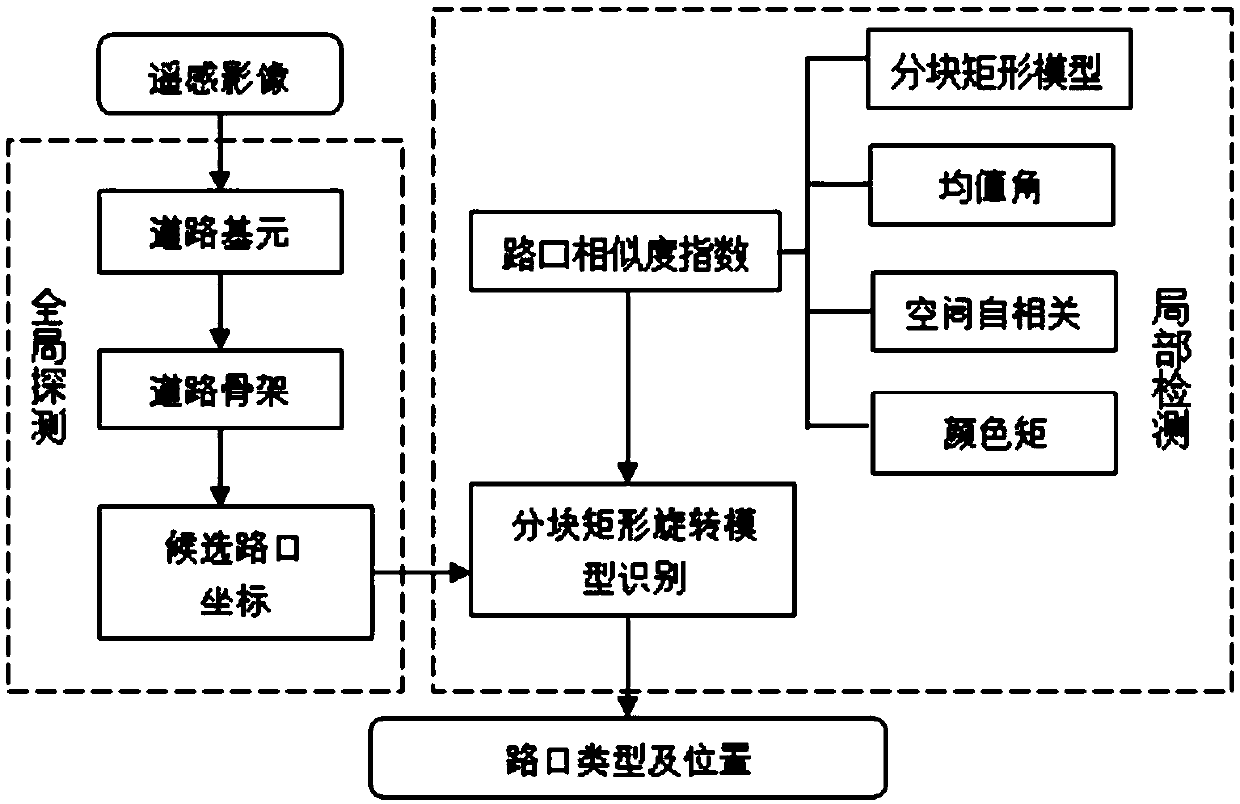
[0054] Such as Figure 1-4 As shown in one of them, the present invention discloses a method for automatic identification of intersections in high-resolution remote sensing images, which includes the following steps:

[0055] S1. Extraction of road primitives: First, rough extraction of roads and non-roads is performed on remote sensing images, and then non-road noise is removed from roads, and finally the morphology of road primitives is repaired by binary morphological operations.

[0056] Specifically, the following steps are included:

[0057] S1.1, rough extraction of road primitives, the specific steps are:

[0058] S1.1.1, feature extraction: use NSCT (Non-Subsampled Contourlet Transform, non-subsampled small contour transform) to decompose the image layer by layer, and use the mean value, standard deviation, homogeneity and other characteristic parameters of the low-frequency sub-band to construct the texture feature vector F1 , and bandpass subband gradient energy, ...


PUM


Abstract

The invention discloses a high-resolution remote sensing image intersection automatic identification method. The method comprises the following steps: S1, road element extraction; S2, communicating road frameworks: connecting adjacent road elements to form a complete road framework; S3, candidate intersection coordinates are generated, specifically, refining operation is conducted on the extractedroad skeleton, and road skeleton intersection points are obtained and serve as the candidate intersection coordinates; S4, constructing an intersection similarity index; and S5, identifying the intersection based on the block rectangular rotation model. According to the method, manual intervention is not needed, the intersection can be automatically extracted, and the extraction accuracy and integrity are superior to those of existing similar research results.

Description

technical field [0001] The invention relates to the field of remote sensing image information extraction, in particular to an automatic identification method for high-resolution remote sensing image intersections. Background technique [0002] Using high-resolution remote sensing images to extract road information is a cost-effective means. Not only can the extraction results be verified intuitively and conveniently through visual comparison, but its cost is also significantly lower than that of road information based on field measured data or mobile trajectory data. method of obtaining. However, the spectral information of ground objects in remote sensing images is rich and the distribution is complex. The phenomenon of "same object with different spectrum" and "different object with same spectrum" is common. The spectral separability of the image is reduced. At present, extracting road information from high-resolution remote sensing images still faces many difficulties a...

Claims


Application Information

Patent Timeline
Patent Type & Authority Applications(China)
IPC IPC(8): G06K9/00G06K9/46G06K9/62
CPCG06V20/182G06V10/56G06V10/462G06F18/2411
Inventor 许锐王晨阳刘石坚
Owner FUJIAN UNIV OF TECH
Why Eureka
Try Eureka